Champaner-Pavagadh Archaeological Park: A Medieval Capital and Sacred Landscape in Gujarat
Site at a Glance
- Rating
- 4.4
- Popularity
- Medium
- Country
- India
- Primary era
- Medieval
- Eras represented
- Medieval
- Civilizations
- Rajput
- Site type
- City
On this page24 sections
History
Champaner-Pavagadh Archaeological Park is a historic urban and religious landscape at Champaner in Gujarat, India, developed by successive Hindu and Muslim rulers and shaped especially by Champaner’s role as Gujarat’s capital in the sixteenth century. Its remains preserve earlier Chalcolithic occupation, an early Hindu hill capital, a medieval fortified city, and a living Hindu pilgrimage centre with Jain associations.
Early occupation and the foundation of Champaner
Archaeological remains and historical records indicate occupation in the Chalcolithic period, although the area appears to have received little attention until about AD 400. Pavagadh’s religious importance is explained in local tradition through the story that the right toe of the goddess Kalika fell on the hill. This tradition underlies the sanctity of the summit and the later prominence of the Kalika Mata shrine.
The foundation of Champaner is associated with Vanraj Chavda, a prominent ruler of the early medieval Chavda dynasty, during the eighth century. One tradition says that he named the city after his friend and general Champa, also known as Champaraj. Another identifies Champa Bhil, described as the last Bhil king of Champaner, as the builder of Champaner Fort and founder of the city during Vanraj’s rule.
Ram Gaur Tuar ruled Champaner in the eleventh century. The city remained under Anhilwad until about 1297, when Alauddin Khalji defeated its rulers and converted it into a stronghold. Chauhan Rajputs, warrior lineages that held power across parts of medieval northern and western India, also settled in the area.
Fortresses and the rise of Muslim rule
Solanki rulers and Khichi Chauhans built and controlled fortresses on Pavagadh Hill. The Khichis used the steep hill and its defensive position to resist the Rao of Idar and the Muslim rulers of Ahmedabad in 1418 and around 1450. Their control of Champaner ended in 1484 after the Gujarat sultan Mahmud Begada defeated them.
In the early 1480s, Raval Jaisingh killed Mahmud Begada’s military commander during a raid in the Champaner area. Mahmud then defeated the Rajputs, surrounded Pavagadh, and maintained a siege for about twenty months. On 17 November 1484, Kiamul Mulk and Malik Ayaz Sultani breached the fortifications and the main gate. Raval Jaisingh was wounded and granted six months’ amnesty, but he was later executed after refusing to convert to Islam. His son accepted Islam and received the title Nizam-ul-Mulk.
After the conquest, Mahmud Begada renamed the city Muhammadabad-Champaner. He laid the foundation of a mosque, strengthened the fortifications, developed the hill fort as Mauliya, meaning “Lord of the Hill,” and built his citadel over twenty-three years. He eventually transferred the capital of Gujarat from Ahmadabad to Champaner, giving the city a central role in the sultanate’s administration.
Capital, prosperity, and decline
Under Mahmud Begada and his successors, Champaner prospered through trade and craft production. The city was known for mangoes, sandalwood used in house construction and sword blades, and brightly coloured silk. Merchants and artisans contributed to the life of the capital, while the rulers continued to govern Gujarat from Champaner after Mahmud’s death in 1511.
Sikander Shah died young in 1526, and Bahadur Shah then became ruler of Champaner. The Mughal emperor Humayun invaded the city in 1535 and looted its treasury. After Bahadur Shah’s death in 1536, the capital and court returned to Ahmadabad. Champaner declined rapidly and became largely abandoned and neglected for several centuries.
Jain religious history
Champaner-Pavagadh was also a Jain pilgrimage centre. Jain tradition extends the site’s religious history to the third century BC, when King Samprati is said to have installed an image of Sambhavnatha consecrated by the Svetambara monk Acharya Suhastisuri. Svetambara is one of the two principal Jain traditions, whose monks traditionally wear white clothing.
In AD 1055, the Svetambara monk Acharya Gunsagarsuri consecrated a temple of Jirawala Parshvanath and rebuilt an ancient temple with fifty-two shrines dedicated to Abhinandanswami. Jain tradition places the foundation of the Achalgacch, a Jain monastic lineage also called Viddhipaksh, at Pavagadh in AD 1112. It associates the foundation with the attempted reforms of Acharya Aryarakshitsuri and with the intervention of Mahakali, whom the order adopted as its protecting deity.
Other traditions refer to the Sarvatobhadra Temple, built by the minister Tejpal in the twelfth century, and to a temple built by Jayawant Seth that was installed and consecrated in 1581. The Mahakali shrine was reconstructed in the sixteenth century under Acharya Kalyansagarsuri by the laymen Sheth Vardhaman and Sheth Padamshin. A temple of Neminatha is mentioned in 1689, while a late-eighteenth-century poem by the Jain monk Dipvijay Kaviraaj described the Jain temples then existing at the site.
Monks of the Achalgacch and Tapagacch lineages consecrated numerous temples and images on the hill. Svetambara scriptures describe these shrines as having once been regarded as equal in importance to those at Palitana. A large Svetambara temple is believed to have suffered repeated invasions, after which its ruins were reused in the construction of three smaller Digambara temples.
Colonial-era decline and modern recognition
The British visited Champaner in 1803, when about 500 people lived among the ruined and overgrown remains of the old city. They refounded the settlement and established facilities for washing silk and preparing raw silk, but a cholera epidemic reduced the population to about 400 families by 1812. When the British took control of the area on 13 July 1829, it was nearly deserted. An attempt to attract cultivators with an incentive of Rs 1260 did not repopulate the settlement, although Bhil and Naikda communities still lived there in 1879.
Modern archaeological study and heritage planning brought the former urban centre into wider historical view. The Baroda Heritage Trust carried out a landscape study and helped prepare a master plan for Champaner and Pavagadh as an archaeological park and cultural sanctuary. With the Trust’s support, the Archaeological Survey of India submitted the World Heritage nomination.
UNESCO inscribed Champaner-Pavagadh Archaeological Park on the World Heritage List in 2004 under criteria (iii), (iv), (v), and (vi). The inscription recognizes its living Hindu pilgrimage tradition, Jain temples, substantially preserved medieval urban fabric, carved sandstone mosques and tombs, and associated intangible heritage. The listed area covers approximately 1,328.89 hectares, with a buffer zone of about 2,911.74 hectares and a primary heritage zone of 983.27 hectares. The park is also important for the transition between Hindu and Muslim culture and architecture in the late fifteenth and early sixteenth centuries, particularly through the survival of an early Islamic, pre-Mughal urban centre.
The Godhra Hindu-Muslim riots affected tourism and produced competing interests concerning infrastructure around the monuments. On 16 June 2024, several Tirthankara images fixed beside the steps of the old route to the Kalika Mata shrine were vandalized and broken. Jain monks and local Jains protested through 17 June. Most of the damaged images were described as more than 400 years old, while some belonged exclusively to the Svetambara tradition.
Remains
The park extends from Pavagadh Hill to Champaner across a landscape of undulating hillocks, plateaus, steep rock exposures formed by ancient volcanic eruptions and lava flows, and reddish-yellow rock on the hill. Pavagadh rises to approximately 800 metres and has forested, uneven ground toward Jambughoda. Champaner lies about 1.6 kilometres south of the hill. Together, the remains include forts, bastions, palaces, gates, arches, mosques, tombs, temples, homes, agricultural buildings, granaries, wells, stepwells, tanks, terraces, walls, and other water installations.
Urban layout and fortifications
City precincts and Jahanpanah
The surviving urban layout includes royal precincts enclosed by fortified walls, a city gate, a mosque outside the main fortifications, and a royal walkway leading toward the palace. Paved streets run toward the city centre. Residential quarters contained houses belonging to wealthy and poorer inhabitants, while elite residences had gardens and water channels. Public parks and pavilions surrounded the residential complexes. A second fortified enclosure, Jahanpanah, a Persian-derived name meaning “world refuge,” remains largely unexplored.
Mauliya and the hill fort
The fortifications begin at the Mauliya plateau and descend toward the plains. They are built largely of sandstone, with regularly spaced bastions and balconies, and include gates, barracks, and jails. The western line combines brick-and-cement construction with an approximately one-mile stretch of unmortared stone wall. A second old wall, about 30 feet high and 220 yards long, joins the upper fortifications.
Bigada’s Wall and the citadel
Bigada’s Wall, a large unmortared-stone barrier, encloses Jahanpanah and the Bhadar, or citadel, of Muhammadabad-Champaner. The enclosed area measures approximately one mile from end to end and 280 yards across. A rectangular guardhouse at the approach to the citadel measures about 150 by 120 feet. Its double gates and elaborately carved stone windows form part of the approach to the fortified centre. Shikari Kot, or Hunters Fort, lies east of the citadel, while Bada Talao, or the Great Lake, is beside the palace ruins.
Gates and structures on the ascent
The hill complex contains a sequence of named gates and associated structures. Atak Gate is also called Gate 1, while Budhiya Gate, or Gate 2, has three gateways. Moti or Sadanshah Gate is Gate 3, and Gate 4 has a large bastion containing interior cells. Sat Manzil stands between Gates 4 and 5, with the mint above Gate 4. Gulan Bulan Gate, or Gate 5, lies near Machi, followed by Buland Darwaza, or Gate 6, and Makai Kothar. Patai Rawal’s Palace has associated tanks. Makai Gate lies near the iron bridge, followed by Tarapore Gate, Navlakha Kothar, and the upper fort walls.
Other recorded structures include the citadel walls, the southeastern citadel walls along the ascent, the eastern and southern Bhadra gates, three cells between Sahar ki Masjid and the foundation of the local Dharmashala, Mandvi or the customs facility, Sakar Khan’s Dargah, and dilapidated houses and Jain temple foundations south of the hill.
Water systems and pilgrimage route
Tanks, wells, and channels
The water system collected rainfall through tanks and ponds on Pavagadh, known as the “hill of a hundred pools,” and through numerous wells in Champaner, called the “city of a thousand wells.” The Vishamitri River rises in the Pavagadh hills and supplied wells at Champaner and tanks on Pavagadh. Tanks served practical, recreational, spiritual, aesthetic, and pilgrimage purposes. Some used embankments to direct stored water into stone cisterns.
The Ganga, Yamuna, and Saraswathi Kunds lie on the Mauliya plateau. Wada Talao, the largest tank, is fed by rivulets on the eastern side of the city, while Gaben Shah Tank forms another major water installation. Decorated spiral stepwells stand in public gardens and at the city entrance. Patai Rawal’s Palace has its own associated tanks, and a channel carried water through the nobleman’s residence known as Amir’s Manzil. The Kabutarkhana Pavilion stands on the northern bank of Bada Talao near Khajuri Masjid.
The Patha
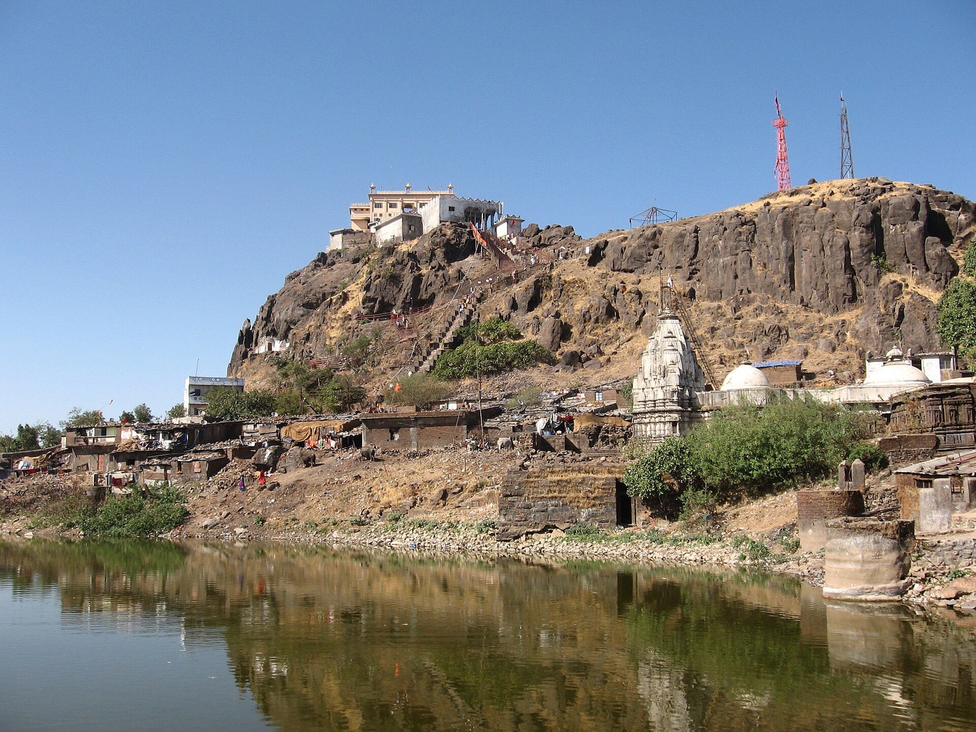
The Patha, or pilgrim route, climbs from the plain toward Pavagadh and contains thousands of steps together with ornamental and utilitarian structures. The ascent passes old gates, natural rock ledges, and stairways on steep slopes. A level area midway up the hill is strewn with boulders; above it, a steep scarp contains a marble temple and two lantern towers. Temples, mosques, and tombs are concentrated mainly on the Pavagadh hills.
Hindu and Jain temples
Lakulish Temple
The earliest recorded temple on the Mauliya plateau is the Lakulish Temple, dated to the tenth or eleventh century. It is now ruined, with the surviving structure limited to the gudha mandapa, an enclosed temple hall, and the Ardha mandapa portion of the antarala, the passage between the inner sanctum and hall. The temple once contained a garbhagriha, or innermost sanctum, a mandapa, an entrance porch, and extensive carved stone decoration.
Its recorded imagery includes Lakulish, Dakshinamurti, Brahma, Vishnu, Gajendramoksha, several forms of Shiva, Indra, seated Ambika, and Surasundaris. These images formed part of the temple’s sculptural programme, whose surviving fragments preserve the range of deities and figures associated with the building.
Jain temple groups
The Jain temples at Pavagadh form three groups. The Bhavanaderi or Navalakka temples stand near Naqqarkhana Gate. Other shrines are dedicated to the Tirthankaras Suparshvanatha and Chandraprabha, revered Jain spiritual teachers. A third group lies southeast of Pavagadh Hill near the Parshva Temple and Dudhia Tank.
Their architectural and stylistic features suggest construction in the fourteenth or fifteenth centuries. Elaborately carved seated and standing Jain images decorate the outer walls, while stone images of Tirthankaras occupy the sanctums. The temples have been renovated over time.
Kalika Mata Temple
The Kalika Mata Temple stands near the summit of Pavagadh at approximately 800 metres. Its central image of Kalika Mata is flanked by Kali and Bahuchara Mata. A shrine to the Muslim saint Sadanandsha Pir occupies the temple spire. The shrine is associated with tantric worship, a ritual tradition using specialized sacred texts, practices, and symbolism, and is regarded as one of Gujarat’s major Shakti Peethas, Hindu shrines linked by sacred tradition to a body part of the goddess Shakti.
The ruins of Patai Rawal’s Palace are visible along the route to the temple. A 740-metre single-cable ropeway connects with the shrine and is described as capable of carrying 1,200 people per hour. The temple’s Chaitra Ashtami fair during Navratri, the nine-night Hindu festival, attracts thousands of devotees.
Mosques and tombs
Jami Masjid
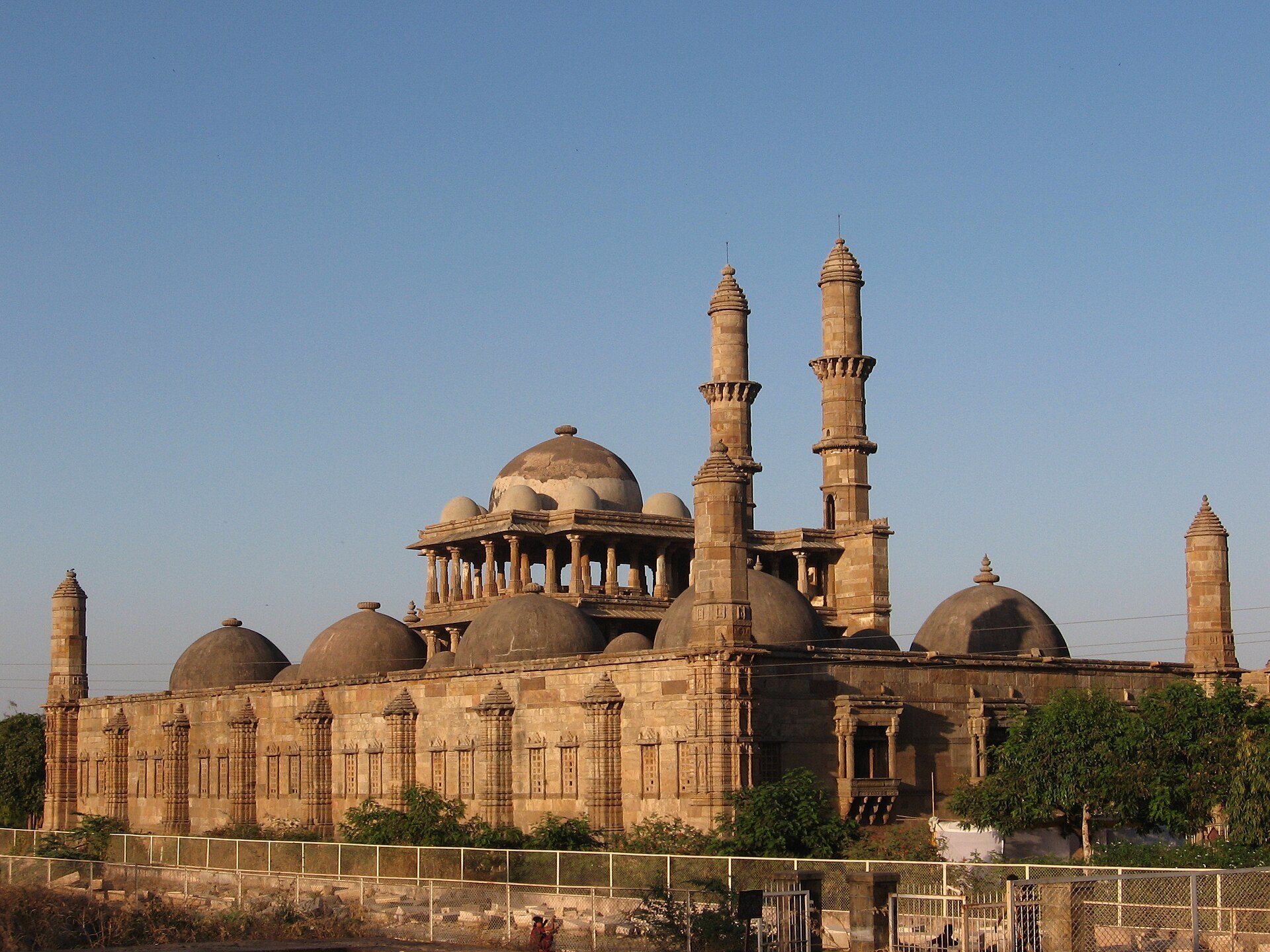
The Jami Masjid, also called Jama Masjid, stands near the eastern gate and was built by Sultan Begada. Raised on a high plinth, it combines Hindu and Muslim architectural elements. The mosque has a central dome, two minarets about 30 metres high, 172 pillars, seven mihrabs, or niches indicating the direction of prayer, ornately carved entrances, and stone jalis, which are perforated stone screens.
Its decoration includes sun, diamond, pot, vine, and lotus motifs associated with earlier temple ornament. Three rectangular mural plaques carry Quranic hymn inscriptions, one above the pulpit and two on its sides. One minaret was deliberately damaged by gunfire in 1812 by Patankar, a Scindia governor.
Other mosques
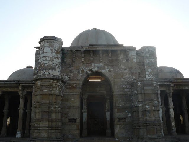
Other mosques include Kevada Masjid and its mausoleum, Ek Minarka Masjid with a single dome, Panch Mahuda ka Masjid with five domes in a forested setting, Shehrka Masjid inside the citadel, Nagina Masjid about 1.21 kilometres south of the citadel, Lila Gumbaz ki Masjid, Kamani Masjid, and Bawaman Masjid. Nagina Masjid is built of white stone, and a nearby stepwell is decorated with arches.
Tombs and shrines
Tombs beside the mosques generally have square plans, columns, domes, and decorative treatment. The tomb near Khajuri Masjid beside Wada Talao has a large central dome and smaller corner domes. The tomb of Sikander Shah near Halol is a simple single-storey Muslim building. Khon Pir is a colourful tomb and shrine associated with the worship of Champaner’s Muslim weaver community.
Civic and domestic remains
Mandvi, the customs house, probably served as a guard room. It has a square plan, five rows of arches, and five equal colonnaded aisles. Another columned building stands on Pavagadh Hill above the roof of the Mahakali Temple. Across the archaeological park, the remains are grouped into eleven broad building types, including mosques, temples, granaries, tombs, wells, walls, and terraces. The Baroda Heritage Trust lists 114 monuments, of which 39 are maintained by the Archaeological Survey of India. Dilapidated houses and Jain temple foundations remain near the southern foot of the hill.