Castro de San Chuis: A Pre-Roman and Roman Fortified Settlement in Spain

Site at a Glance
- Rating
- 4.2
- Popularity
- Very Low
- Country
- Spain
- Primary era
- Iron Age
- External website
- Open
- Eras represented
- Iron Age, Classical
- Civilizations
- Roman
- Site type
- Military
- Remains
- Fortified Town
On this page8 sections
History
Origins and Iron Age occupation
Castro de San Chuis is a pre-Roman fortified settlement in Spain, located in Allande, Asturias, near San Martín de Beduledo. A radiocarbon sample from the upper quarter produced a date possibly belonging to the first half of the eighth century BC, supporting a possible first occupation at the beginning of that century. The duration of this earliest settlement remains uncertain. The site forms part of a historical development whose origins extend into the final phase of the Bronze Age, while radiometric dates, metal, stone, and ceramic objects, together with building alterations, confirm substantial Iron Age occupation.
During the Iron Age, the hilltop held a strongly fortified settlement with a modular perimeter wall and numerous ditches. Its defensive arrangement corresponds to practices found at later Iron Age hillforts in the region. A castro, the term used for this type of fortified hilltop settlement in northwestern Iberia, could remain in use and change substantially as political conditions developed.
Roman transformation
Occupation continued during the Roman period, when the settlement was extensively remodelled. Its position near the gold-bearing resources of the Narcea valley, together with its advantageous location and proximity to regional routes, may have given it a place within the Roman political and administrative order. San Chuis has consequently been interpreted as a possible regional center within the territory of the Paesici, an ancient people of northwestern Iberia, and within the imperial tributary system organized through civitates, Roman administrative communities or territorial units. This interpretation remains provisional rather than an established fact.
A proposed late-Roman reoccupation was once based mainly on particular ceramic materials. Those objects were later identified as regional products of the early imperial period, removing the principal evidence for a late-Roman phase. No additional evidence has established that interpretation.
Excavation and changing interpretations
José Lombardía Zardaín discovered the settlement in 1952. Through Alfonso Pérez Garrido, it was examined by Francisco Jordá Cerdá and Carlos María de Luis. J.M. González surveyed the site in July 1962, prepared a detailed plan, and later included it in his 1966 catalogue of Asturian hillforts. Excavations began in the lower quarter in August 1962 under Jordá Cerdá and continued the following year with Elías Domínguez. Further campaigns under Jordá Cerdá resumed in 1979 and continued until the summer of 1986, concentrating mainly on the upper quarter.
Radiocarbon samples sent to the University of Barcelona in 1990 and 1992 produced dates published in 1996 that confirmed pre-Roman occupation horizons. Two samples processed in the early 1990s were described as providing unequivocal Stone Age dates, alongside the wider evidence for Iron Age occupation. Beginning in 1997, a research project directed by J.F. Jordá Pardo and M. García Martínez combined topographic surveying, material inventories, geophysical investigation, radiocarbon dating, and studies of animal and charcoal remains. The same year, San Chuis was incorporated into the Management Plan for the Navia Basin, which provided for improvement works, structural consolidation, restoration, and archaeological testing. Cleaning, maintenance, and restoration campaigns in 2005 and 2006 followed. The settlement was declared an Asset of Cultural Interest in the archaeological-zone category in 2014.
Although systematic excavation has not resumed since 1986, later assessments have repeatedly revised the site’s historical sequence. Earlier interpretations emphasized the Roman phase and its relationship to the administration of a gold-rich territory, while radiocarbon research established the importance of the settlement’s pre-Roman occupation.
Remains
Fortified enclosure
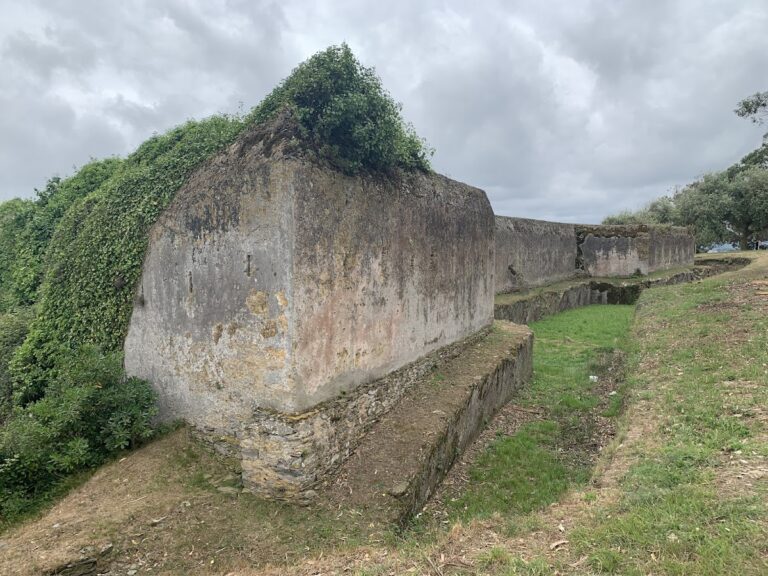
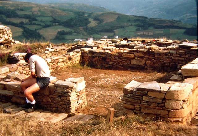
The settlement occupies one of the highest points in its surroundings, reaching 783 metres on a line of flattened summits between the valleys of the Prada River to the north and the Abaniecha River to the south. Its enclosure has an approximately triangular plan. A modular wall follows the perimeter, while ditches concentrate along the more vulnerable sides. On the western side, a large forward trench protects the strip of ground between the ditch and the wall, creating an outer defensive area. On the southwest, six defensive ditches are paired with corresponding counter-ditches. The eastern and northern slopes have no recognizable defenses beyond the encircling wall. Remains on the eastern flank have been interpreted as an access gate.
Buildings and architectural phases
More than twenty structures have been partly or completely excavated inside the enclosure. They belong to more than one period, and several rooms in the upper quarter may have formed parts of single buildings. Fifteen structures were identified there, including eight exposed during excavations in the 1960s and seven uncovered during campaigns in the 1980s. Most have simple circular or oblong plans associated with pre-Roman hillfort architecture. Two structures have quadrangular plans. One was divided into two rooms, a form associated with Roman-period hillfort architecture, and was built against a circular hut. At least eight further structures appear to have formed one or more complex dwellings linked with early imperial occupation horizons. The superimpositions show a change from single-room circular or oblong buildings to Roman domestic arrangements with rectilinear, subdivided plans or rounded corners. In some cases, circular buildings were incorporated into or replaced by the later domestic complex.
Excavated materials
Metal, stone, and ceramic objects recovered from the excavations are associated with the pre-Roman occupation and help define the site’s Iron Age use. The excavated material also includes thin-walled ceramics attributed to the pottery workshop at Melgar de Tera. Their identification as products of the early imperial period contributed to the reassessment of the settlement’s Roman sequence and to the rejection of the earlier interpretation of a late-Roman reoccupation.