City Walls of Brno: A Medieval Fortification System and Baroque Fortress
Site at a Glance
- Rating
- 4.6
- Popularity
- Low
- Country
- Czechia
- Primary era
- Medieval
- Eras represented
- Medieval, Early Modern
- Civilizations
- Habsburg, Holy Roman Empire, Kingdom of Bohemia
- Site type
- Military
- Remains
- Wall
On this page17 sections
History
The City walls of Brno in Czechia were a medieval urban fortification system built during the thirteenth century to protect the city and enclose the relatively small area around its present centre. Their first written reference appears in the 1243 Great Privilege of Wenceslaus I, the thirteenth-century king of Bohemia, although the wording may have been copied partly from earlier texts and does not conclusively prove that the walls already stood at that date.
Medieval fortifications
During the fourteenth century, the walls were improved and additional gates were built. Under John of Luxembourg, King of Bohemia, Brno’s Jewish inhabitants were required to contribute one quarter of the amount collected from the city’s non-Jewish inhabitants for repairs. Two of the twelve city councillors were assigned responsibility for administering the fortifications.
The defences were strengthened in 1420, when Brno expected an attack by the Hussites, a reform movement whose military campaigns challenged Catholic and royal authority in Bohemia. After 1486, the fortified area was extended around the Augustinian monastery. Further improvements followed in 1508 because of the threat of an Ottoman attack. During a major rebuilding in the sixteenth century, the gates were strengthened with barbicans, outer defensive structures placed before a gate or wall.
The Augustinian monastery had functioned as a separate fortress from the beginning. It was divided from the city by the original walls and later by a water-filled ditch, and its defences were strengthened before the Swedish siege of Brno in 1645. The final major rebuilding of the medieval fortifications took place before that siege.
The siege of 1645 and the baroque fortress
During the 1645 siege, the fortifications helped protect Brno from the Swedish army. After the siege failed, Brno was intended to become a fortified city, but a shortage of funds delayed the work. Construction began about ten years later, after Emperor Ferdinand III ordered the defences to be urgently strengthened because of the outbreak of the Swedish-Silesian War.
The inner bastion system and its ditch were designed in the 1660s by the imperial engineer Giovani Tensini. Giovanni Battista Pieroni also participated in fortification works in Brno and at Špilberk. The baroque fortress, with eight bastions, was completed by 1688. Its bastions were projecting fortifications designed to let defenders fire along the faces of adjoining walls. Once this system was complete, the medieval walls were largely abandoned as the city’s principal defence.
In the 1730s, Filip de Rochepine designed an additional, lower outer line of bastions in front of the ditch. Further alterations were made in the 1740s during the Prussian invasion of the Bohemian lands, and the city fortress was connected with the citadel on Špilberk. A citadel was a strongly fortified position intended to dominate or defend a city, and Špilberk fulfilled that role within Brno’s later defensive system.
Demolition and later history
The medieval fortifications declined gradually after the seventeenth century as the bastion system temporarily assumed their defensive function. Sections of the medieval walls were demolished, and their masonry was reused in new residential buildings. The ditch was filled on the southern and eastern sides, although some covered sections survived as cellars. Most barbicans were removed, while those at the Jewish and Brno Gates remained.
Napoleon Bonaparte’s army occupied Brno at the beginning of the nineteenth century. During its final withdrawal in 1809, Napoleon ordered the destruction of part of Brno’s fortification system, including most of the defences at Špilberk and the outer bastion line. Former bastion areas were later converted into landscaped spaces, including the park now called Denisovy Sady and a promenade avenue on the eastern side of the city.
An order issued by Emperor Francis Joseph I on 25 December 1852 ended Brno’s status as a military city. The remaining fortifications were then demolished. The bastion line was removed during the 1860s, although the section near the railway station had disappeared earlier. A representative ring boulevard was created over the site of the baroque fortifications and was later partly built over.
Gates and surviving evidence
The original five gates were the Běhounská, Brněnská, Měnínská, Veselá, and Židovská Gates. Hackelova and Nová Gates were added later for limited periods. The gates were guarded continuously, closed at night, and used to store weapons and gunpowder. By the end of the Middle Ages, all had barbicans.
The Běhounská Gate was built in 1252 and rebuilt in 1354 to 1356 in connection with the nearby Augustinian monastery. Later called the Tišnovská Gate and, from the late seventeenth century, the Dřevěná or Wooden Gate, it remained in use after the bastion fortifications were built. It was demolished before 1817. The Brněnská Gate was first recorded in 1269, although it was probably older. Gunpowder stored there exploded after a lightning strike in 1596, severely damaging the gate, which disappeared between 1848 and 1852.
The Měnínská Gate was first recorded in June 1293 and was more heavily guarded because many attackers approached Brno from the southeast. It was moved to Orlí Street during the first half of the fourteenth century, while a smaller gate remained at its original location. The gate was newly built or substantially rebuilt around 1500 and received a clock at the end of the sixteenth century. After the bastion system reduced its defensive importance, it was lowered by one storey in 1839 and adapted for residential use. Following municipal administration and twentieth-century reconstruction, it became exhibition space for the Brno City Museum.
The Veselá Gate was first mentioned in 1340. It was rebuilt and moved farther from the city in the 1670s because of the bastion construction, while a New Veselá Gate was built in the curtain wall between the bastions. A curtain wall is the section of wall between two defensive projections. The original gate disappeared in the eighteenth century, and the New Veselá Gate was demolished around 1859 to 1860.
The Židovská Gate, first recorded in 1328, was the only entrance through which Jews were permitted to enter the city, and a special Jewish toll was collected there. Inner and outer gate towers were built in 1350 to 1353. The gate was substantially rebuilt in 1508 and decorated by Antonín Pilgram, a late Gothic sculptor and architect associated with Moravian and Central European works. It was rebuilt and moved farther from the city in 1663, then demolished in stages before and after 1817. A smaller Ferdinand Gate was built on the site of the third gate in 1835 and demolished in 1864.
Hackelova Gate was built in 1744 in the bastion line toward the former village of Švábka. Restricted to internal city traffic and frequently closed, it became known as the Blind Gate and was demolished in 1861. The Nová Gate was established in 1786 in the curtain wall in front of the former Měnínská Gate, at a location where only a stream had flowed after the bastion system was built. It was demolished in 1863.
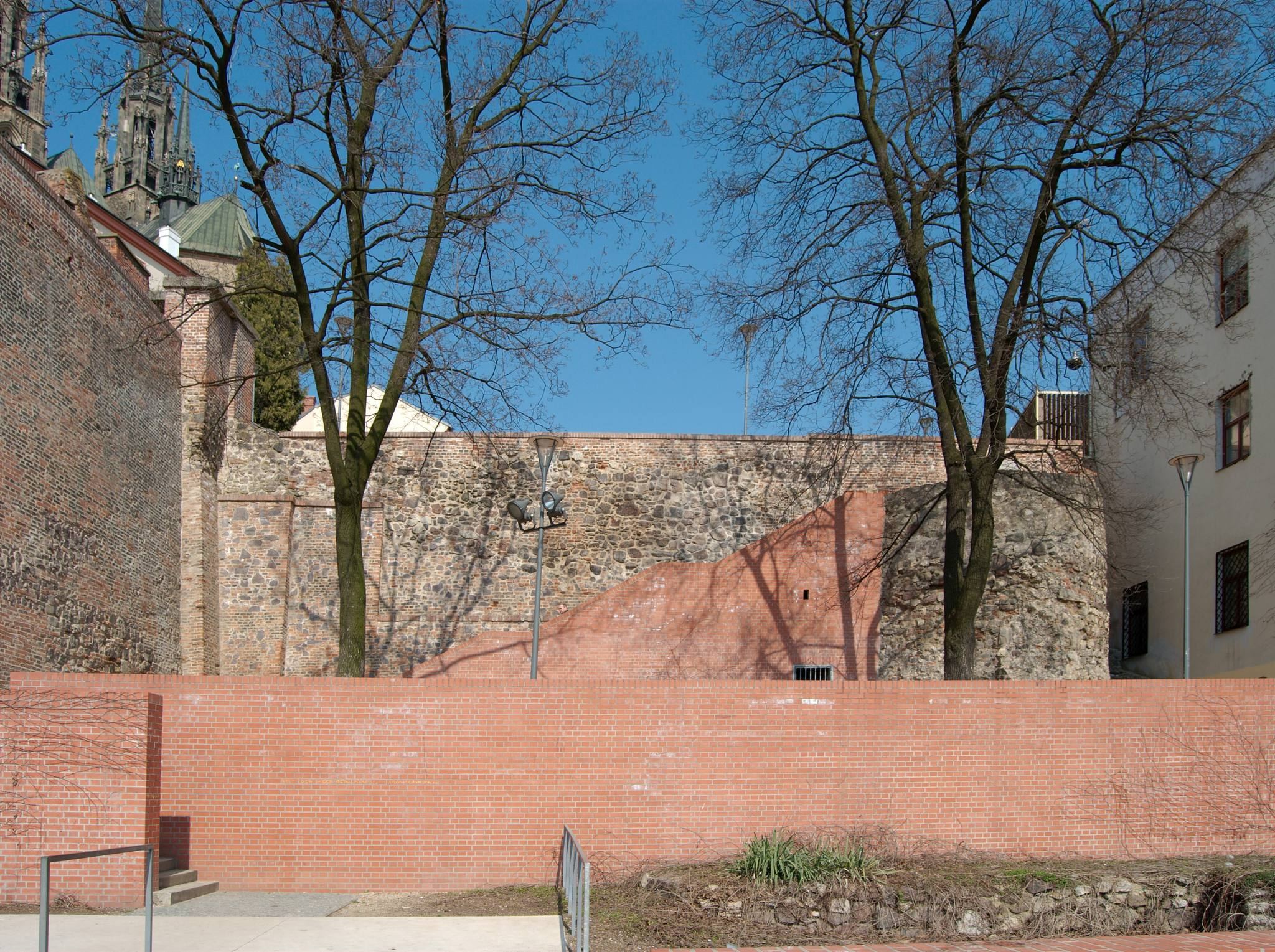
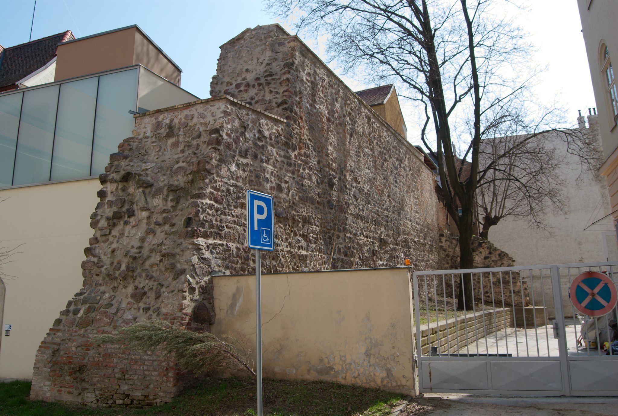
On 23 March 1964, the surviving remains were registered as immovable cultural monuments under heritage registration number 26220/7-208. The best-preserved wall section, behind the Secondary School of Arts and Crafts on Husova Street, was repaired and documented between 1998 and 2001. Special resin was used to secure its structural function. The surviving section beneath Petrov, including a bastion, was also reconstructed. Another section behind Jezuitská Street 13 was partly damaged by an insensitive reconstruction in 2005.
Archaeological investigations examined the remains of the Veselá Gate during construction of Brno’s underground utility collector in 2007. Remains of the Běhounská Gate foregate were found in 2004, and further parts of the Běhounská or Dřevěná Gate were uncovered during the reconstruction of Běhounská Street in 2010.
Remains
Medieval wall circuit
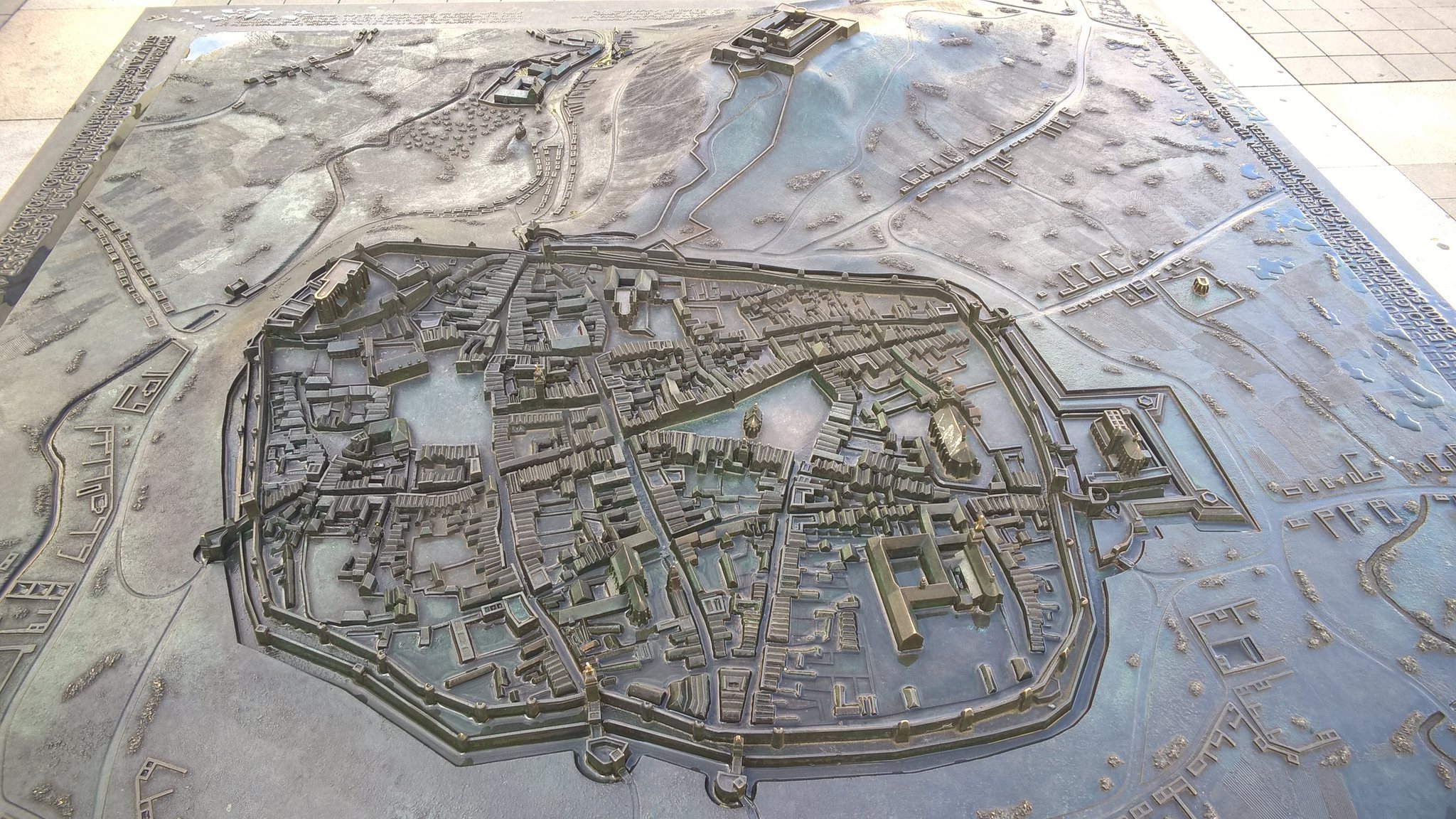
The medieval walls followed a slightly oval plan with longer eastern and western sides. They enclosed approximately 36.4 hectares within a circuit about 2,250 metres long. The line ran roughly from present-day Solniční Street to the site of Janáčkovo Theatre, turned south toward Rooseveltova Street, continued through the areas of Sukova, Měnínská, Novobranská, and part of Josefská Streets, then turned north near the end of Bašty Street around Petrov and followed Husova Street back toward Solniční Street.
An outer parkan wall stood beyond the main wall, separated from it by a narrow strip of ground. A ditch, mostly filled with water, followed the defences. Behind Petrov the ditch could not be flooded in some places, so a third wall was added to strengthen the position. Towers, the parkan wall, barbicans, and later bastions formed parts of the wider defensive arrangement.
The number of medieval towers is estimated from historical images and varies between reconstructions. Oldřich Vičar counted 43 towers on the main wall, spaced about 40 metres apart, while the original number may have been as high as 50. The parkan wall probably had 11 towers. Images made before the 1645 siege show 43 towers on the main wall and 12 on the parkan wall.
Husova Street wall
The surviving medieval sections are built of unlayered quarry stone around a poured core. They are approximately 1.6 to 2.2 metres thick, while their original height cannot be determined. At Husova 10, a section reaches about 10 metres high. Behind the Secondary School of Arts and Crafts, the best-preserved stretch is about 37 metres long and rises 7.5 metres at its highest point. It includes part of a wall tower and blocked openings about 0.2 by 1.8 metres, probably made for supports holding a projecting timber hoarding, a defensive gallery or parapet from which defenders could observe or attack enemies below.
Petrov and Jezuitská Street remains
A surviving section beneath Petrov forms part of the Petrov terraces and includes one bastion. Numerous other fragments remain on Petrov’s south-western side, including masonry incorporated into some canons’ houses. Another fragment behind Jezuitská Street 13 is approximately 29 metres long and one metre wide; part of it was compromised by the 2005 reconstruction.
Former ditch and later fortress
Parts of the medieval ditch were roofed and converted into cellars, some of which survive. The later baroque fortress comprised an inner line of bastions with a water ditch, a lower outer bastion line, and a fortified connection to the Špilberk citadel.
Gate remains
Běhounská Gate
The Běhounská Gate stood where Běhounská and Kozí Streets meet, on routes toward Královo Pole and onward to Bohemia and Silesia. Its former foregate remains lie in a small park between the Governor’s Palace and Janáčkovo Theatre. Other fragments survive in underground spaces beneath Běhounská Street and beneath the street itself.
Brněnská Gate
The Brněnská Gate stood at Šilingrovo Square between Dominikánská and Starobrněnská Streets, on the route toward Staré Brno and Mikulov. One of its emblems survives on the courtyard-facing side of a house at Údolní 7.
Hackelova and Nová Gates
Hackelova Gate stood in the bastion line toward present-day Údolní Street and served internal city traffic. Nová Gate occupied the curtain wall in front of the former Měnínská Gate, within the later defensive arrangement.
Měnínská Gate
The Měnínská Gate on Orlí Street is the only complete city gate of Brno’s fortification system to survive. Its height was reduced by one storey in 1839, and the building now contains exhibition spaces of the Brno City Museum.
Veselá Gate
The Veselá Gate stood at the junction of Veselá and Česká Streets, on the route toward Veveří Castle and the Bohemian-Moravian Highlands. Its former remains were examined archaeologically in 2007. The New Veselá Gate stood in the curtain wall between the bastions.
Židovská and Ferdinand Gates
The Židovská Gate stood where Masarykova Street reaches the railway station. It was originally a triple gate with inner and outer towers. Some components are preserved in the lapidarium at Špilberk, while the former Ferdinand Gate is commemorated by a stone relief on the corner of a house at the beginning of Masarykova Street.
Only fragments of the original city fortifications survive apart from the complete Měnínská Gate. Other remains include sections behind Domini Park near Hotel International, a medieval wall adjoining Denisovy Sady, fragments beneath Běhounská Street, masonry incorporated into the Petrov terraces, and the section behind Jezuitská Street 13.