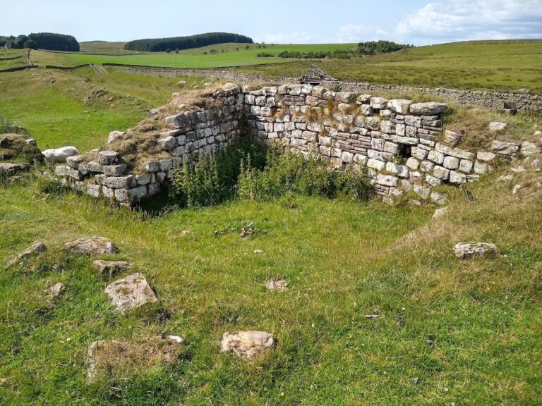
Milecastle 48: A Roman Fort on Hadrian’s Wall


Site at a Glance
- Rating
- 4.6
- Popularity
- Low
- Country
- United Kingdom
- Primary era
- Classical
- External website
- Open
- Eras represented
- Classical
- Civilizations
- Roman
- Site type
- Military
- Remains
- Fort
On this page11 sections
History
Milecastle 48, also known as Poltross Burn Milecastle, is a Roman fort on Hadrian’s Wall in the United Kingdom. Built as part of the frontier ordered by Emperor Hadrian in the AD 120s, it stood at the north-western limit of the Roman Empire and controlled a crossing through the Wall at the Poltross Burn.
A milecastle was a small Roman fort placed at intervals along Hadrian’s Wall, normally about one Roman mile apart. It usually contained a gateway, accommodation, storage buildings, and a small garrison. Milecastle 48 probably housed about 30 soldiers, who could patrol the frontier and regulate movement into and out of the Roman province of Britannia.
Foundation and Roman use
The site formed part of the original plan for Hadrian’s Wall, before the building scheme was changed to include larger forts along the frontier. Its position was strategic. The Wall crossed the fast-flowing, rocky Poltross Burn, a tributary of the River Irthing, at the western edge of a steep and narrow ravine. The Stanegate, a Roman road that preceded Hadrian’s Wall, crossed the burn a few hundred yards to the south, while the minor fort of Throp stood on a ridge to the south-west.
Archaeological excavation shows Roman occupation from the earliest phase of Hadrian’s frontier, in the AD 120s, through to the 4th century. During this period the buildings and gateways were altered several times. Barracks that had originally been divided into four rooms were reorganised into three larger rooms. The gateways were designed for double gates but were later narrowed to single portals by blocking walls, possibly restricting passage to pedestrians. Five ovens were built in succession, each above the foundations of its predecessor. Finds associated with mounted troops also suggest that horsemen may have been stationed here at some stage.
Excavation and later identity
Investigations were carried out in 1886 under R. S. Ferguson, between 1909 and 1911 under J. P. Gibson and F. G. Simpson, and in 1965 and 1966 under D. Charlesworth. These excavations revealed the successive changes made during the milecastle’s Roman use, as well as its unusually well-preserved interior.
By the early 19th century, local people knew the monument as “The King’s Stables”, probably because its preserved interior resembled stable blocks. It is now generally called Poltross Burn Milecastle and is cared for by English Heritage.
Remains
Milecastle 48 is an unusually large rectangular enclosure, measuring about 18.5 metres from east to west and 21.3 metres from north to south. It stands on a slope descending towards Hadrian’s Wall, whose stone curtain forms the northern side. A broad perimeter wall enclosed the site, with gateways in the north and south sides connected by a paved central road. Short wing walls joined the enclosure to the narrower stone curtain on either side.
Main enclosure
Buildings and terraced interior
Two long rectangular buildings, probably used as barracks and stores, flanked the central road and occupied much of the interior. They probably had pitched roofs covered with stone slates, while verandas sheltered paths beside the road. Because the milecastle was built on a slope, the buildings were terraced and stepped so that their rooms could have level floors.
A cooking area with a round oven occupied the north-west corner. Five successive ovens were constructed there during the Roman period, each replacing an earlier one. Excavation also exposed the lower courses of the long barrack blocks, preserving the arrangement of the internal buildings and the relationship between them and the central road.
Gateways and defenses
The gateways were built in Type III form, an archaeological classification for a particular milecastle gateway design. The northern gateway is better preserved than the southern entrance, and its substantial masonry was strong enough to support a tower. Both gateways were originally intended for double gates before blocking walls reduced them to single passages.
A substantial stone stairway in the north-east corner led to the rampart walk, the walkway along the top of the defensive wall. The surviving stair and its angle indicate that the wall-walk stood about 3.6 metres above ground level. A crenellated parapet protected the walkway, giving the wall an estimated external height of about 5.3 metres.
Excavated objects
Objects recovered from the milecastle include a brooch, a jasper intaglio from a finger ring, pieces of scale armour, horse-harness fittings, and a copper-alloy chape probably made in the 2nd century AD. A chape was the fitting at the bottom of a Roman sword scabbard, where it protected the wearer from the sword point. This example is held at Tullie House Museum in Carlisle.
Associated turrets
Turret 48A, Willowford East
Turret 48A, also known as Willowford East, was a small fortified tower associated with the milecastle. It stood on a river terrace on the south bank of the River Irthing and measures about 4.1 metres across. Excavated in 1923, it retains consolidated masonry. The north wall survives to a maximum height of 1.3 metres, while the east wall survives to seven courses, the west wall to five, and the south wall to six. Its doorway was in the south-west wall. Hearths and evidence of bronze- and ironworking were found inside. The remains were cleared and partly rebuilt in 1951 and 1952.
Turret 48B, Willowford West
Turret 48B, or Willowford West, stood on the south bank of the River Irthing immediately east of Willowford Farm. Excavated in 1923, it survives as consolidated masonry above ground. As a turret, it formed part of the chain of small fortified towers normally placed at intervals along Hadrian’s Wall and could have been manned by soldiers from the nearby milecastle.
Nearby sites