Uruk: An Ancient Mesopotamian City in Iraq


Site at a Glance
- Rating
- 4.6
- Popularity
- Low
- Country
- Iraq
- Primary era
- Bronze Age
- Eras represented
- Bronze Age, Iron Age, Classical
- Civilizations
- Assyrian, Babylonian, Parthian, Seleucid, Sumerian
- Site type
- City
On this page22 sections
History
Uruk, in Iraq, was an ancient Mesopotamian city built and developed by the communities of southern Mesopotamia from the fifth millennium BC onward. Occupied from the Ubaid period into late antiquity, it remained a religious and political center for roughly four millennia and gave its name to the Uruk period of the fourth millennium BC.
Origins and the Uruk period
The settlement began as two earlier Ubaid communities associated with the later Eanna and Anu districts. These settlements eventually formed one city. Kullaba, a name connected with the Anu area, may have been a separate settlement that merged with Uruk, although ancient texts more often treat it as a quarter or an alternative name for the city.
The Uruk period is an archaeological sequence that runs from the late Ubaid levels through Early, Middle, and Late Uruk levels XII to IV, followed by level III, which corresponds to the Jemdet Nasr period around 3100 to 2900 BC. Its absolute chronology remains approximate and debated. Uruk was a type site for this period, meaning that its archaeological remains help define the period itself.
During the fourth millennium BC, Uruk played a leading part in the growth of cities, the formation of states, the development of administrative systems, and the emergence of writing in southern Mesopotamia. Its society became highly stratified, with powerful institutions, long-distance trade, monumental construction, and complex systems for managing labor and resources. Cultural practices associated with Uruk spread into parts of Mesopotamia, Syria, and the wider Middle East. The existence of a centralized proto-empire based at Uruk, however, cannot be established.
The city expanded from about 70 hectares early in the fourth millennium BC to approximately 100 hectares and then 230 to 250 hectares by the end of the Uruk period. During the Early Dynastic period, the enclosed city covered about 400 hectares, although some reconstructions estimate an area of roughly 600 hectares around 2800 BC. Uruk was probably the largest settlement in southern Mesopotamia during the later fourth millennium BC and may have been the world’s largest urban area around 3100 BC. Population estimates range from approximately 40,000 people around 3500 BC to between 50,000 and 80,000 around 2900 BC, with further inhabitants in the surrounding region.
Gods, rulers, and the Early Dynastic city
Uruk’s earliest major religious identity centered on Inanna, a goddess associated with sexuality, fertility, political power, warfare, and the planet Venus. Her sanctuary occupied the Eanna district. The western Anu district developed around a sanctuary later called Bit Resh, meaning approximately “House of Primacy,” and was dedicated to Anu, the sky god, and later to his consort Antu. In the archaic period Inanna appears to have held the more prominent position, while Anu and Antu became the principal divine pair during the first millennium BC.
Later traditions linked Uruk with Meskiangasher, Enmerkar, Lugalbanda, Dumuzi, and Gilgamesh. The Sumerian King List, a Mesopotamian historical text that combines legendary and historical rulers, credits Enmerkar with the foundation or construction of Uruk and associates the city wall with Gilgamesh. These traditions do not establish that the events occurred as described. Gilgamesh is placed by the list in the twenty-seventh century BC, but his historical existence and the details of his reign remain uncertain. Later literature nevertheless made him Uruk’s most famous ruler.
In the Early Dynastic period, the age of Sumerian city-states conventionally dated here to approximately 2900 to 2340 BC, Uruk was a major regional power. Enshakushana claimed the titles “king of Sumer” and “king of the land.” Lugal-zagesi, originally ruler of Umma, made Uruk the capital of his kingdom after conquering much of southern Mesopotamia. Sargon of Akkad later defeated him.
Akkadian, Ur III, and Amorite rule
Uruk remained important under the Akkadian Empire, although it participated in revolts against Akkadian rule. Amar-girid is described as leading a southern coalition against Naram-Sin. Some details concerning this revolt and the later Gutian invasions remain uncertain. After Akkadian power declined, Uruk regained independence.
Utu-hegal, traditionally described as a ruler or governor of Uruk, was credited with defeating the Gutian ruler Tirigan and briefly ruling Sumer. Ur-Nammu, probably his brother, then established the Third Dynasty of Ur. Under Ur-Nammu and his successor Shulgi, Uruk underwent an economic and cultural revival. The Eanna sanctuary was restored, and its ziggurat, a stepped monumental platform or tower associated with a temple, was constructed.
The collapse of the Third Dynasty of Ur around 2004 BC may have brought destruction and political subordination. Uruk successively entered the spheres of Isin and Larsa, with brief periods of independence during the nineteenth century BC. Around 1860 BC, Sîn-kashid founded a new Amorite dynasty at Uruk. He restored Eanna and built a large royal palace, while his daughter Nish-inishu served as high priestess of a temple institution.
Larsa probably annexed Uruk around 1802 BC, and Sîn-kashid’s palace was probably destroyed at that time. Hammurabi of Babylon briefly recovered the city in 1787 BC. After Hammurabi conquered Larsa in 1763 BC, Uruk became part of the Babylonian kingdom. During the revolt against Samsu-iluna, Rîm-Anum ruled Uruk for a time. Tablets from his administration record prisoners and enslaved war captives.
Samsu-iluna reconquered Uruk around 1740 to 1739 BC and claimed to have demolished its walls. The city was then largely deserted, while some members of its clergy moved to Kish to preserve the cults of Ishtar and Nanaya. Uruk’s decline coincided with wider political and economic difficulties in southern Sumer.
Later Babylonian and Assyrian periods
Uruk was gradually reoccupied during the second half of the second millennium BC under Kassite Babylonian rule, although its population remained much smaller than before. Kurigalzu I restored the Eanna sanctuary, and Kara-indash built a small temple there in the late fifteenth century BC. Its molded fired-brick facade, showing bearded gods alternating with goddesses holding overflowing vessels, introduced an innovative form of decoration.
Religious and urban life revived under later Babylonian and Assyrian rule. Neo-Assyrian rulers annexed the region and made Uruk a provincial center. Later Neo-Babylonian kings restored temples, walls, and canals, although Uruk retained greater religious than political importance. Under Nabopolassar and his successors, including Nebuchadnezzar II and Nabonidus, the city benefited from extensive restoration programs.
In the seventh and sixth centuries BC, the Eanna temple was Uruk’s principal economic institution. Its administration included a chief administrator, a chief deputy, and the local “scribe of Eanna.” Under Nabonidus, royal supervision increased and an official was appointed to monitor the sanctuary. Eanna controlled between 10,000 and 17,000 hectares of cultivated land, along with date plantations, sheep flocks, cattle, poultry, workshops, residences, and commercial operations. Farmers, shepherds, gardeners, artisans, merchants, brewers, cooks, textile workers, and other specialists worked for or under the institution.
The sanctuary’s religious economy supplied daily offerings of grain, animals, beverages, clothing, jewelry, furniture, and other goods. Estimated daily offerings to Ishtar included about 360 liters of barley and 66 liters of wheat, quantities that could supply approximately 100 people according to contemporary ration levels. Religious observances included the sacred marriage ritual, in which the king symbolically took the role of Dumuzi, the consort of Inanna. The Festival of the Boat of Heaven involved offerings to Inanna over at least five days during the tenth month of the local calendar.
Hellenistic, Parthian, and late antique Uruk
During the Achaemenid and Hellenistic periods, Bit Resh became more important than Eanna. The principal cult of Ishtar and Nanaya was transferred or subordinated within the new religious organization, while the Anu temple also centralized the cult of Shamash’s Ebabbar temple at Larsa. By the mid-third century BC, a major building program had made Bit Resh one of the last large sanctuaries constructed in the Mesopotamian architectural tradition.
Uruk was relatively autonomous under Seleucid rule and may have served as an administrative center for the surrounding region. It prospered during the Seleucid and Parthian periods, when the occupied area during the Hellenistic period covered approximately 300 hectares. Local elite families controlled civic and temple offices, maintained hereditary religious and administrative positions, and acted as intermediaries between the city and Seleucid authorities.
Priestly families continued to teach cuneiform, the wedge-shaped writing system impressed into clay, and preserved Mesopotamian religious, ritual, mathematical, astronomical, technical, and literary traditions. They did so while Aramaic and Greek alphabets became increasingly widespread. The Eanna archives include at least 10,000 tablets and fragments from the seventh and sixth centuries BC, with about 2,000 additional tablets apparently originating from the sanctuary. Most are administrative records, offering lists, letters, and economic documents. The principal archive includes approximately 250 literary tablets, while the additional material contains about 400 letters.
Uruk remained a major provincial center under Parthian rule. Cuneiform documentation continued into the late second or first century BC. A contract dated to 108 BC shows that the temple of Anu was still functioning, while an astronomical text dated to AD 79 or 80 may be the latest known cuneiform text from the city.
The city declined during the later Parthian period. Around AD 100, the Dollamenoi built a temple to the otherwise unknown deity Gareus, indicating a substantially changed religious environment. Uruk declined after the beginning of Sasanian rule, but the date of final abandonment is uncertain. It may have occurred around the seventh century, shortly before or around the Islamic conquest of Mesopotamia in AD 633 to 638.
Rediscovery and archaeological work
William Kennett Loftus identified Uruk with the biblical Erech and located and first excavated the ruins between 1849 and 1854. Walter Andrae surveyed the site in 1902. The German Oriental Society began systematic excavations in 1912 under Julius Jordan and Conrad Preusser.
Work continued under the German Oriental Society and later the German Archaeological Institute. Major field directors included Arnold Nöldeke, Ernst Heinrich, Heinrich Jakob Lenzen, Jürgen Schmidt, Rainer Michael Boehmer, and Margarete van Ess. By 2001, forty-one excavation campaigns had been conducted. Excavations, surveys, and geophysical research continued intermittently after 1989 and resumed in 2015, using magnetometry, core sampling, aerial photography, satellite imagery, and research on the city wall and surrounding landscape.
A boat dated to approximately 2000 BC was discovered during renewed excavations in 2022 in remarkably well-preserved condition. Uruk Archaeological City forms part of the UNESCO World Heritage property Ahwar of Southern Iraq, inscribed in 2016 under criteria iii, v, ix, and x. The Uruk component covers approximately 541 hectares and has a buffer zone of approximately 292 hectares. The ancient name survives in the modern name Warka, while the proposed derivation of Iraq from Uruk remains disputed.
Remains
Uruk’s archaeological site covers approximately 5.5 to 6 square kilometers, extending about 3 kilometers from north to south and 2.5 kilometers from east to west. The ruins now lie northeast of the Euphrates because the river changed course from its ancient position southwest of the city. The former channel is dry, and the river’s displacement may have contributed to Uruk’s decline.
The city was organized around two major temple zones. Eanna occupied the eastern side and was associated with Inanna, while the Anu district lay to the west on a large artificial terrace. Courtyard houses occupied residential areas around both districts, and occupational groups appear to have clustered in separate quarters. Canals connected the city with the ancient Euphrates, supported river transport, and linked the urban area to the agricultural zone. In the first millennium BC, the principal waterways included the Canal of the King, which followed an earlier Euphrates course, and the Takkiru. Fields and marshes also occupied parts of the walled urban area.
Uruk buildings generally used either a tripartite plan, with three parallel halls, or a T-shaped plan, in which a central hall extends into perpendicular bays. The principal archaeological areas include Eanna, Bit Resh or Kullaba-Anu, the Irigal or South Building area, Parthian structures, and the ancient city wall with the palace of Sîn-kashid and the Seleucid Bit Akitu.
The Eanna district
Early monumental buildings
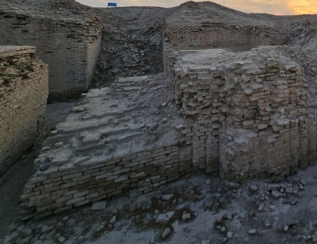
Eanna contains at least seven monumental buildings from the later Uruk period, either superimposed or adjoining one another. Their traditional identification as temples remains uncertain because the excavated structures do not have clear cult installations. The complex may have included temples, palaces, administrative buildings, and other institutional structures.
The Stone-Cone Temple, also called the Mosaic Temple, was built in Eanna level VI over an earlier Ubaid-period temple. Its limestone walls had elaborate buttresses, and its facade was decorated with colored stone cones inserted into mud brick. The building was probably dismantled or ritually destroyed in level IVb, when its contents were deposited in the later Riemchen Building.
The Limestone Temple and Riemchen Building
The Limestone Temple was constructed in level V about 100 meters east of the Stone-Cone Temple. It stood on a podium roughly 2 meters high above earlier Ubaid structures and measured approximately 30 by more than 80 meters. Its central hall was about 12 meters wide. Limestone came from an outcrop approximately 60 kilometers east of Uruk, although it is uncertain whether the entire structure or only its foundation used the stone.
The building had a tripartite plan, a buttressed facade, corners aligned with the cardinal directions, and cone-mosaic decoration. It was probably associated with Inanna, although it cannot be identified with certainty as her temple. The later Riemchen Building used small brick units about 16 by 16 centimeters, known as Riemchen. Built after the destruction of the Stone-Cone Temple, it may have served as a memorial to that structure. A ritual fire was maintained at its center, and its facade may have carried geometric and figural decoration.
Level IV buildings and courts
Eanna level IV contained Buildings F, G, H, K, B, E, C, and D, together with the Small Brick Building, Red Temple, Great Hall, Pillar Hall, Round Pillar Hall, Cone-Mosaic Courtyard, and Great Court. The function of many of these structures remains uncertain.
Building E, also called the Square Building, was arranged around a large square courtyard, with four units on each side. Its large rooms contained two pillars. It was first interpreted as a palace and later as a communal or public building. The Red Temple occupied the former site of the Limestone Temple and was probably constructed in level IV or during the transition to the following phase. Its name comes from the colored coating or plaster that covered its walls.
The Great Hall and Pillar Hall stood in the northwestern part of Eanna, while the Round Pillar Hall occupied the eastern part. The Great Court lay to the west and may have been a garden. Later descriptions identify it as a sunken courtyard with two tiers of benches covered in cone mosaic.
Later Eanna structures and the ziggurat
At the transition from level IVb to IVa, earlier buildings were demolished and their debris was used to create a large terrace. Buildings C, D, and M, the Great Hall, and the Pillar Hall were then built on it. The reason for the destruction of the level IVa buildings in level III is unknown. In level III, the earlier monumental complex was replaced by baths, the Great Court area, and a labyrinthine rammed-earth building with fortress-like characteristics. Inanna’s temple continued in a new form called the House of Inanna in Uruk, although its location is unknown.
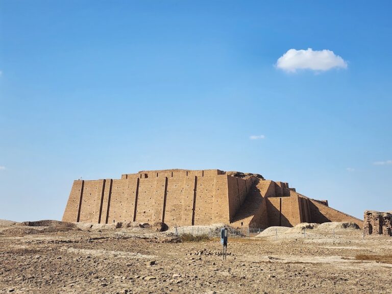
The Eanna ziggurat was built during the Third Dynasty of Ur under Ur-Nammu and Shulgi. Its nearly square base measured approximately 55 by 51.5 meters. The surviving ruins rise about 14 meters, while the original structure may have reached approximately 30 meters. A triple staircase provided access, and the ziggurat probably had two or three stages crowned by a temple.
The Anu district
The terrace and White Temple
The Anu district was formed principally by a massive artificial terrace, raised through repeated construction. Archaeological work identified fourteen architectural levels, designated from L or X through A3. The White Temple was built on the terrace at the level corresponding approximately to Uruk III, around 3000 BC.
The temple’s walls were coated with white gypsum plaster. It stood on a platform about 13 meters high and measured approximately 22.3 by 17.5 meters, with walls preserved in places to about 3 meters. A central rectangular hall opened toward rooms along its longer sides and contained an altar. Its raised position and form make it an early precursor of the later Mesopotamian ziggurat tradition.
The Stone Temple
The Stone Temple lay beneath the northwestern end of the White Temple terrace and belongs approximately to Anu-area level VI. It was built of limestone and bitumen on a rammed-earth podium resting on a woven reed structure called giparu. The podium was finished with lime mortar. Channels, tanks, and vessels found within the building may indicate libation rituals.
The structure was ritually destroyed, covered with alternating layers of clay and stone, later reopened, and filled with mortar. Here giparu refers to the reed construction beneath the podium, rather than to the sacred institution or residence associated elsewhere in Uruk with high-ranking priests and priestesses.
Palaces, later sanctuaries, and the city wall
The palace of Sîn-kashid
The palace of Sîn-kashid occupied an unusual peripheral position west of the Kullab quarter. It measured approximately 100 by 145 meters, although only its foundations survive. The eastern ceremonial sector centered on a large court and two elongated rooms, one probably the throne room. The western sector contained storage rooms and administrative offices, while the king’s private and household quarters probably occupied an upper floor.
Kassite and first-millennium sanctuaries
Kara-indash’s Kassite-period temple in Eanna measured approximately 14 by 18 meters. Its facade had corner towers and molded fired-brick reliefs showing bearded gods alternating with goddesses holding overflowing vessels. The facade is preserved in the Pergamon Museum.
During the Neo-Babylonian and Neo-Assyrian periods, Eanna formed a cultic complex approximately 330 by 350 meters across. It was organized around a ziggurat and several courtyards, sanctuaries, chapels, thick enclosure walls, archives, and service rooms. Bit Resh, the temple complex of Anu and Antu, occupied approximately 213 by 167 meters and contained more than twenty-two chapels arranged around at least nine courtyards. Its ziggurat had a square base about 110 meters on each side.
The Irigal was a major southern complex associated with Ishtar and Nanaya. An inner wall approximately 205 by 198 meters enclosed it, and the governor Anu-uballit, also known by the Greek name Kephalôn, restored it in AD 201.
Hellenistic and Parthian buildings
The Bit Akitu was a festival temple outside the city to the northeast, built during the Hellenistic period. It was square, measuring approximately 140 meters on each side, and centered on a courtyard about 90 meters square. A processional route connected it with Bit Resh during the akitu, a major Mesopotamian festival involving ritual movement between temples.
The temple of Gareus was built around AD 100 during the Parthian period. Its sacred enclosure measured approximately 60 by 63 meters, while the central temple measured about 13.7 by 10.5 meters. It combined Mesopotamian and Greco-Roman features, including a square cella, the principal inner room of a temple, blind arcades, column bases, and nearby Ionic capitals.
Another Parthian building has apsidal remains. Heinrich Lenzen interpreted it as a mithraeum, a sanctuary associated with Mithra, but it may instead have been a church belonging to an early Christian or Gnostic community in southern Mesopotamia.
The city wall
Uruk’s ancient city wall extended for approximately 9 kilometers and enclosed the urban area. Excavated sections show brick construction and surviving heights of approximately 12 to 15 meters. Tradition associates the wall with Gilgamesh, but its archaeological development is connected with the Early Dynastic or Jemdet Nasr phases.
Writing, art, and archaeological evidence
More than 5,000 tablets from Uruk levels IV and III document the earliest stages of writing. The first tablets are mainly administrative, recording quantities, products, people, and institutional transactions. During the Jemdet Nasr period, reeds with triangular ends began to be used, contributing to the development of cuneiform. The relationship between earlier accounting devices, including cylinder seals, clay tokens, and clay envelopes, and the first written signs remains uncertain.
Uruk-period art included cylinder seals, cone mosaics, reliefs, sculpture, realistic depictions of animals and daily activities, and images of a bearded figure known as the “priest-king.” The alabaster Uruk vase, approximately 1.2 meters high, shows an offering procession led toward Inanna. The Mask of Warka, also called the Lady of Uruk, is a marble female face dating to approximately 3100 BC and may represent Inanna. It was looted from the Iraq Museum in 2003, recovered later that year, and returned.
Beveled-rim bowls were standardized Uruk-period vessels generally interpreted as containers for distributing food or drink rations to dependent laborers. The fast potter’s wheel was introduced during the later Uruk period, allowing pottery to be produced in larger quantities and with greater standardization.
Excavations and geophysical surveys have identified buried structures beneath the former Euphrates channel. One interpretation connected these remains with the tomb of Gilgamesh described in later literature, but the structure has not been excavated and there is no firm proof that it was a tomb. Modern investigations have used magnetometers, electrical-resistivity probes, sediment cores, aerial photographs, satellite imagery, and digital reconstruction. Ground-penetrating radar is unsuitable for the site’s soil conditions.