Aşıklı Höyük: An Aceramic Neolithic Settlement in Türkiye
Site at a Glance
- Rating
- 4.6
- Popularity
- Low
- Country
- Turkey
- Primary era
- Stone Age
- External website
- Open
- Eras represented
- Stone Age
- Civilizations
- Unclassified
- Site type
- City
On this page17 sections
History
Aşıklı Höyük is an Aceramic Neolithic settlement in Türkiye, occupied approximately from 8200 to 7400 BC during the early Neolithic period. The Aceramic Neolithic was the pre-pottery phase in which communities developed permanent settlement, cultivation, herding, and new craft technologies. Located beside the Melendiz stream in the volcanic Cappadocia region of Central Anatolia, the site preserves a long transition from mobile hunter-gathering to sedentary life.
Settlement and subsistence
The community remained at Aşıklı Höyük for nearly a thousand years rather than abandoning the settlement between major phases. Radiocarbon evidence places the occupation in three principal levels containing approximately twelve or thirteen phases. Successive rebuilding, changing architectural arrangements, and gradual economic and technological developments trace the community’s changing way of life.
During the ninth millennium BC, people combined broad-spectrum hunting and plant gathering with the management of sheep and goats. They harvested wild and domesticated cereals and legumes, and began cultivating wheat and barley. Sheep and goats were kept within or near the settlement, including in enclosures made from acacia wood and mud, although domestication was still developing. Cattle, red deer, hare, fish, birds, and other animals also contributed to the food economy.
Water, fertile soils, varied ecological zones, plant and animal resources, and nearby raw materials supported the settlement. Obsidian, a volcanic glass that fractures into very sharp edges, was central to the material economy. Central Anatolian sources may have contributed to exchange networks reaching as far as Cyprus and Iraq, although Aşıklı Höyük has not been demonstrated to have been a major centre for distributing obsidian across Cappadocia and beyond.
Changing houses and community life
The settlement’s architecture changed during its occupation. Ninth-millennium residents used semi-subterranean oval mudbrick buildings and reed-woven huts. These buildings were repeatedly repaired and renewed in the same locations, with walls, floors, and hearths maintained while the structures remained in use. After their primary use ended, some houses became refuse areas.
In the eighth millennium BC, adjoining rectangular mudbrick houses replaced the earlier oval buildings. Most had a single room, while others had two or three. Their standardized plans and internal arrangements continued for centuries. Residential buildings formed clusters interpreted as neighbourhoods or compounds, with shared courtyards used for production, cooking, and eating. This arrangement reflects a settled community whose social and economic organization developed through repeated rebuilding rather than a single planned foundation.
Daily activities included cooking, processing hides and skins, working obsidian, bone, and antler, making baskets and beads, and preparing plant foods. The settlement’s inhabitants therefore combined farming and animal keeping with practices inherited from hunter-gatherer lifeways and techniques associated with early farming and herding communities of northern Mesopotamia and the Levant.
Burial customs and early technologies
Some of the dead were placed beneath building floors while the houses continued to be used. Approximately 70 people, including men, women, and children, were buried beneath more than 400 excavated rooms. The number of burials and the range of ages and sexes indicate that burial beneath houses involved selection, while interpretations of the practice as an elite privilege remain debated.
Children form more than one-third of the buried individuals, and many died during their first year. Some adult female skeletons have spinal deformities associated with carrying heavy loads. Male skeletons show joint disease and trauma that may relate to timber cutting and cultivation, although these findings alone do not establish a gendered division of labour. Burial customs changed over time. Personal ornaments are absent from graves in the middle of the ninth millennium BC but occur in some burials by the middle of the eighth millennium BC. More than half of the skeletons show evidence of burning, and graves contain either single individuals or pairs.
Aşıklı Höyük is also associated with early lime production and copper working. Lime was burned and slaked in a special-purpose building, while native copper was worked hot and cold to make beads. One young woman, approximately 20 to 25 years old, underwent trepanation, a surgical opening made in the skull. Bone healing indicates that she survived the operation for about a week.
Discovery and archaeological research
Edmund Gordon first identified Aşıklı Höyük in 1963. In 1964 and 1965, Ian A. Todd carried out extensive surface collection, sectioning, and dating work, gathering more than 6,000 obsidian pieces and initially placing the settlement approximately 9,000 to 10,000 years in the past.
Excavation began in 1989 as salvage work after plans to raise the water level of the Mamasın reservoir threatened to inundate the mound. The threat did not materialize. Istanbul University conducted the first excavation phase under Ufuk Esin, with Savaş Harmankaya as deputy director. Nur Balkan Atlı directed work from 2000 to 2003. By 2003, nine campaigns had exposed approximately 4,200 square metres, around 12.5 percent of the site.
A second phase of excavation and interdisciplinary research began in 2006 under Mihriban Özbaşaran and Güneş Duru. New research questions and methods brought specialists from several countries into the work. Excavation and conservation also led to new approaches to displaying the settlement and to projects involving the surrounding community. The site is administered by the Aksaray Museum Directorate and is recognized as an archaeological site.
Remains
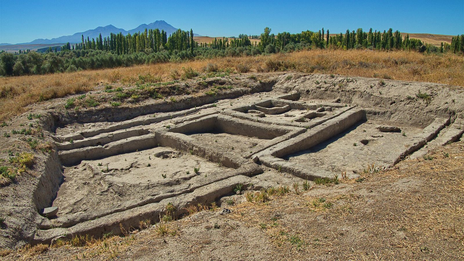
Aşıklı Höyük covers approximately 4 hectares at an elevation of about 1,120 metres. The mound lies beside the Melendiz stream in a valley eroded into volcanic tuff. Repeated changes in the river channel have eroded its western part. Excavated remains reveal two principal functional zones: a residential area in the north and a southern area containing special-purpose buildings, separated by a gravel road.
Ninth-millennium dwellings and work areas
Oval mudbrick buildings
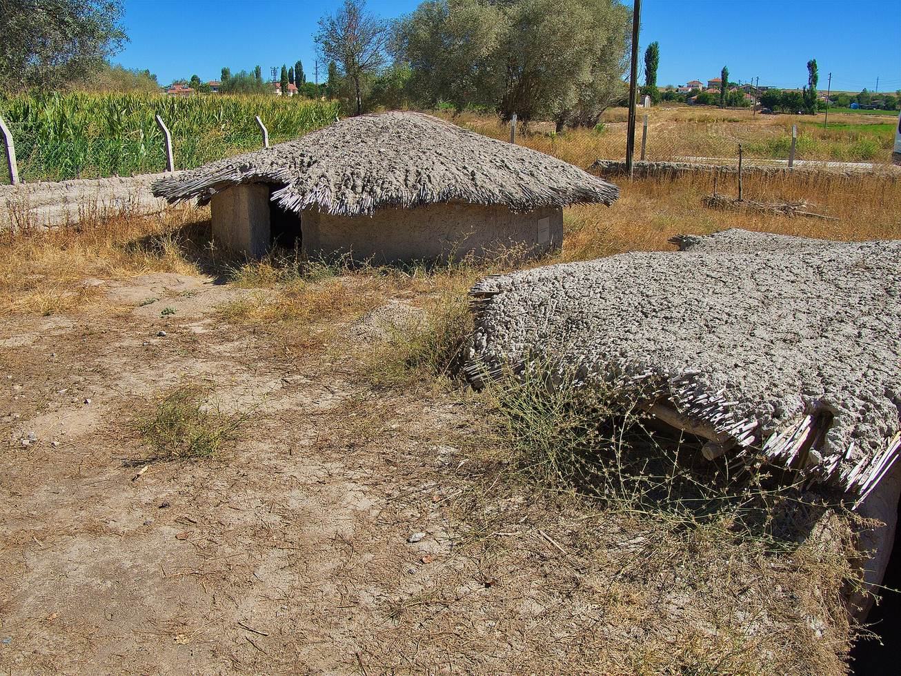
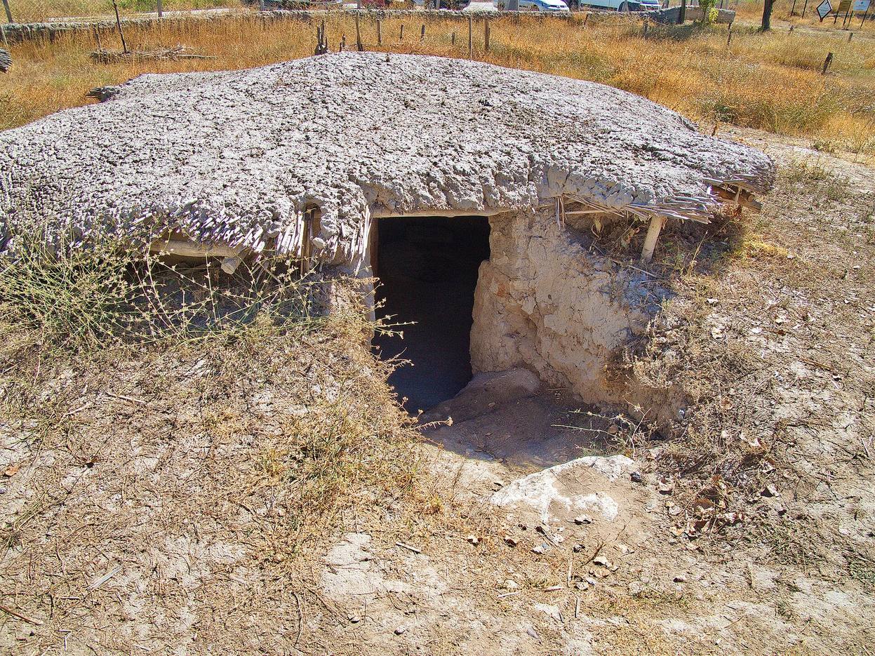
The ninth-millennium buildings were partly sunk into the ground and built with mudbrick, an earth-based material dried rather than fired. Their oval plans included plastered floors, mudbrick walls, hearths, postholes, benches or platforms, and small and large pits. Some pits held posts that supported the roofs. Walls and floors were repeatedly repaired, and hearths were often renewed in the same positions, producing long sequences of rebuilding on the same alignment.
Graves were cut through the plastered floors. Most bodies were placed in a hocker position, with the limbs drawn toward the torso, while other burials were extended or placed on their sides, sometimes with bent knees. Burial orientation and the number of bodies varied. Some graves contained beads, necklaces, or bracelets. One burial held a young woman with an elderly man, and another contained a young woman and an infant. Gypsum-filled deposits occurred in some graves, a practice also known from eastern Anatolia.
Open activity areas
Much of the ninth-millennium work took place in open areas between the buildings. Large cooking pits, animal bones, plant remains, bone tools, awls, obsidian tools, and flaking debris reflect cooking, food processing, hide and skin working, stone working, bone and antler manufacture, basketry, and bead production. These spaces connected domestic life with the production of tools, ornaments, and processed food.
Eighth-millennium residential compounds
Rectangular mudbrick houses
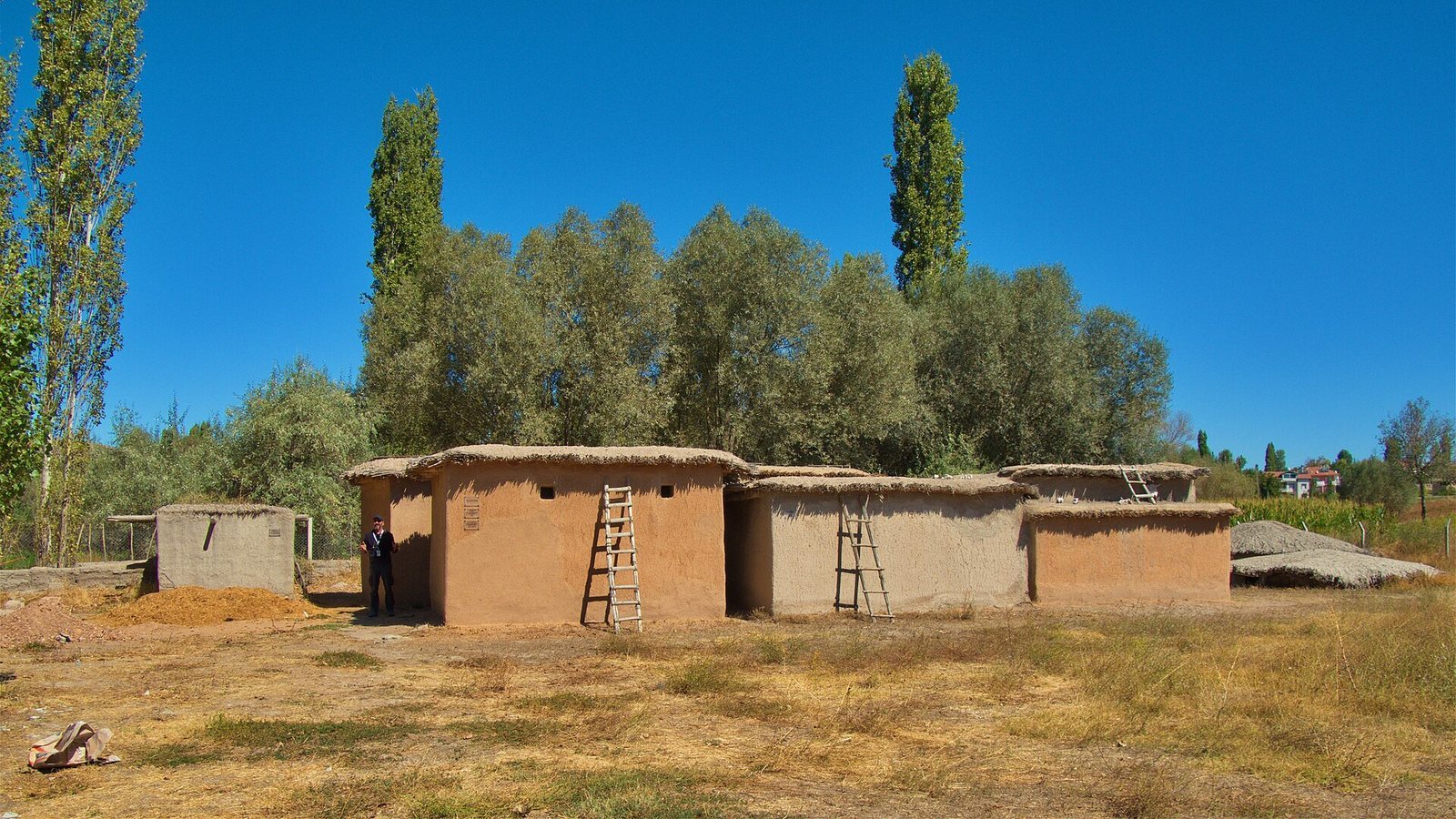
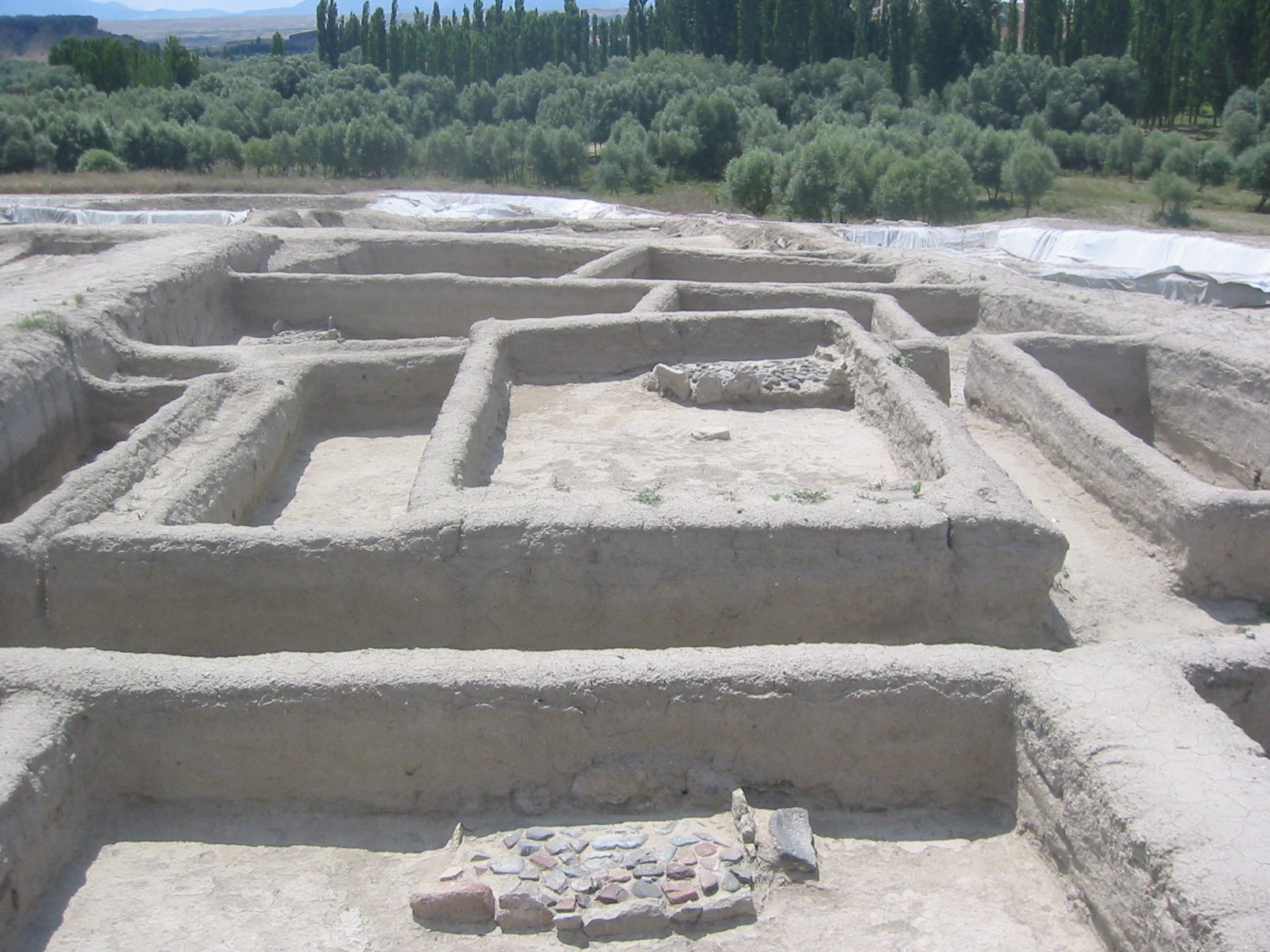
The later houses were rectangular and generally built directly beside one another. Most had one room, with an average area of approximately 12 square metres; two or three, and sometimes five or six, dwellings formed a compound. Multi-room buildings had openings through their partition walls. Entrances were probably reached from flat roofs, possibly with wooden ladders, or through high openings in the walls.
Hearths, benches, pits, and postholes formed the main internal features. Hearths were usually placed in the southern part of a room, while some pits served for burials beneath the floor. The buildings were standardized in plan, size, and internal arrangement over several centuries. Narrow alleys, approximately 0.5 to 1 metre wide, and open courtyards reaching about 4 metres in diameter separated the compounds. The alleys opened onto communal refuse areas, while the courtyards supported production, cooking, and food consumption.
Hearths and rebuilding sequences
Hearths occur in roughly 30 to 40 percent of the rooms. They are rectangular and usually occupy a corner, with areas ranging from about 0.48 to 2.97 square metres. Flat stones formed an upright edge around 20 centimetres high, leaving the short side open as a fire mouth where ash accumulated. Pebbles along the base and edges appear to have been covered with a thin plaster layer, and traces of flues occur only rarely.
Hearths are more common in single-room houses than in multi-room buildings and do not occur in courtyards. Their positions vary between buildings but remain associated with a wall and are often rebuilt in the same corner through successive phases. Earlier structures were commonly rebuilt on their original locations and alignments, sometimes using older walls as foundations. Some sequences may represent 240 to 480 years of repeated rebuilding if individual buildings lasted 30 to 60 years, although the actual use-life of each structure remains uncertain.
Special-purpose and communal buildings
Southern special-purpose area
The southern zone contained two eighth-millennium buildings that differed from domestic houses in size, plan, materials, and internal features. Separated from the residential area by the gravel road, the zone has been interpreted as a communal space associated with social and possibly ritual practices. The precise functions of the buildings remain uncertain.
One building had a stone-built northern wall, an internal courtyard, plastered walls painted red, and a floor partly paved with large mudbrick blocks. A second building farther south had an approximately square plan, mudbrick walls, repeatedly renewed floors painted red and yellow, and internal features including a channel and a bench.
Large multi-room structures
Other large buildings contained several rooms and substantial internal courts. Their walls were heavier and more massive than those of domestic structures, and they were not integrated into the residential clusters. Their size and arrangement indicate functions different from those of ordinary houses, although their precise uses are uncertain.
The complex designated HV measured approximately 25 by 20 metres, or 500 square metres. Its scale could have accommodated activities involving several hundred people, while the settlement’s estimated population may have numbered in the thousands and access may have been restricted to selected groups. This evidence provides a physical basis for considering how communal activities and restricted forms of participation operated within the settlement.
Tools, ornaments, and medical evidence
Obsidian accounts for most chipped-stone tools. A small number of flint tools were imported from another region. The assemblage includes points, abundant scrapers, geometric and crescent-shaped microliths, and pieces made with the microburin technique. Obsidian was also used for bracelets. One surviving fragment has exceptionally regular workmanship, indicating advanced technical skill; its production may have taken place outside the settlement in eastern Anatolia.
Native copper beads were found in two graves, attached to the necks and arms of the dead. A single clay figurine represents an animal. Plant remains, animal bones, bone tools, grinding stones, beads, obsidian tools, and other production debris provide physical evidence for cereal use, gathering, hunting, animal keeping, hide processing, stone working, and domestic activities. The trepanated skull of the young woman preserves healed bone around the deliberate opening, indicating survival for a short period after the operation.
Conservation and reconstruction
The excavated special-purpose buildings are displayed beneath a protective roof that preserves their mudbrick architecture while allowing research and visitation throughout the year. At the entrance, an experimental prehistoric village reproduces ninth- and eighth-millennium BC structures through full-scale experimental methods. It includes semi-subterranean oval houses, rectangular mudbrick houses, their internal features, and a reed-woven building, helping present the architectural sequence revealed by excavation.