Tumulus d’Er Grah: A Neolithic Megalithic Tomb at Locmariaquer
Site at a Glance
- Rating
- 4.3
- Popularity
- Very Low
- Country
- France
- Primary era
- Stone Age
- External website
- Open
- Eras represented
- Stone Age
- Civilizations
- Unclassified
- Site type
- Burial
- Remains
- Burial Mound
On this page12 sections
History
The tumulus d’Er Grah is a Neolithic megalithic burial monument at Locmariaquer, France, built by communities of Neolithic western Europe between about 4500 and 4000 BC. It formed part of the same archaeological complex as the Grand Menhir brisé d’Er Grah and the Table des Marchand. Its successive construction phases reflect major changes in funerary practice and the treatment of earlier monumental stones.
Early activity and ritual deposits
Before the monument was built, people used the area for activities represented by several hearths and pits. Around 4500 BC, small burial or offering installations were established and apparently covered by low mounds of stone and earth.
During the third quarter of the fifth millennium BC, two large domesticated bovines, still resembling aurochs, were buried in one of the pits. The aurochs was the now-extinct wild ancestor of modern cattle. The animals had been skinned and partly defleshed during a complex ritual. An arrowhead lay between the ribs of one bovine, while a complete Castellic vessel, pottery associated with a Neolithic cultural tradition of western France, was placed at the top of the structure. Ten beads made from variscite, a green mineral used for prehistoric ornaments, were deliberately scattered across several square metres outside a funerary structure.
Construction and transformation
Around 4200 BC, or shortly afterward, builders created the dolmen and its burial chamber. A dolmen is a prehistoric chambered tomb made from upright stones and large covering slabs. The chamber was first enclosed within a circular cairn, meaning a stone mound often faced with stone, and was then incorporated into a larger trapezoidal cairn.
Later work extended the monument to the north and south, creating an exceptionally long tumulus, or burial mound made from earth, stone, or both. The southern extension was directed toward the Grand Menhir brisé d’Er Grah and ended at its foot. This suggests that the menhir was still standing when the extension was built, although orthogneiss blocks incorporated into the tumulus indicate that the earlier menhir alignment was already being dismantled. Orthogneiss is a banded metamorphic rock formed from an earlier igneous rock, and it was used at Locmariaquer for exceptionally large slabs.
The monument was probably intended as the burial place of a high-status individual. The chamber had been robbed before modern investigation, so its possible skeletal remains and grave goods were removed. The reuse of orthogneiss fragments from earlier large menhirs in funerary and other monumental structures has been interpreted as evidence of a major cultural and religious transformation around 4200 BC.
Damage, excavation, and protection
In the nineteenth century, only the clearly visible burial chamber was recognized, while the tumulus itself was not clearly identified by archaeologists. A drawing made by W. C. Lukis around 1864 placed the chamber correctly but greatly exaggerated the width of the mound, giving it as 61 metres.
Zacharie Le Rouzic excavated chiefly the chamber in 1908 and made brief investigations at the northern and southern ends. He described the northern end as intact, but it was exploited as a quarry around 1933. The cadastral plot later carried the name Er Vinglé, meaning “the quarry” in Breton. Stone had already been removed from the tumulus during the medieval period, or possibly earlier, and the northern end was shortened. Earth may also have been extracted, leaving no earth between parts of the stone facing.
The tumulus was damaged and became overgrown. In 1971, its southern part was levelled and converted into a car park. Comprehensive excavation of the Grand Menhir, the tumulus, and the Table des Marchand took place between 1986 and 1994. Work in 1991 cleared the area around the tumulus and exposed dry-stone walls, while restoration carried out in 1992 produced its present appearance.
The tumulus has been protected as a French historic monument since 16 January 1935. The wider megalithic heritage of Carnac and the shores of Morbihan was listed as a UNESCO World Heritage property in 2025 under criteria (i) and (iv).
Remains
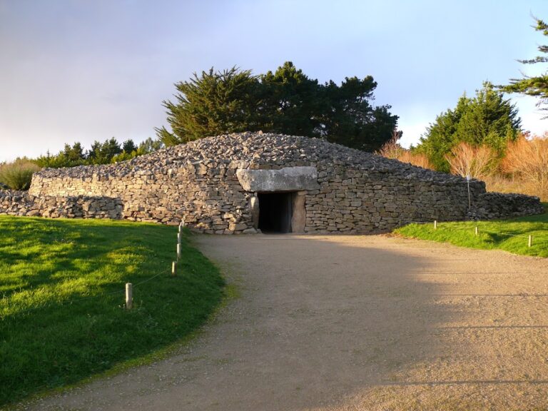
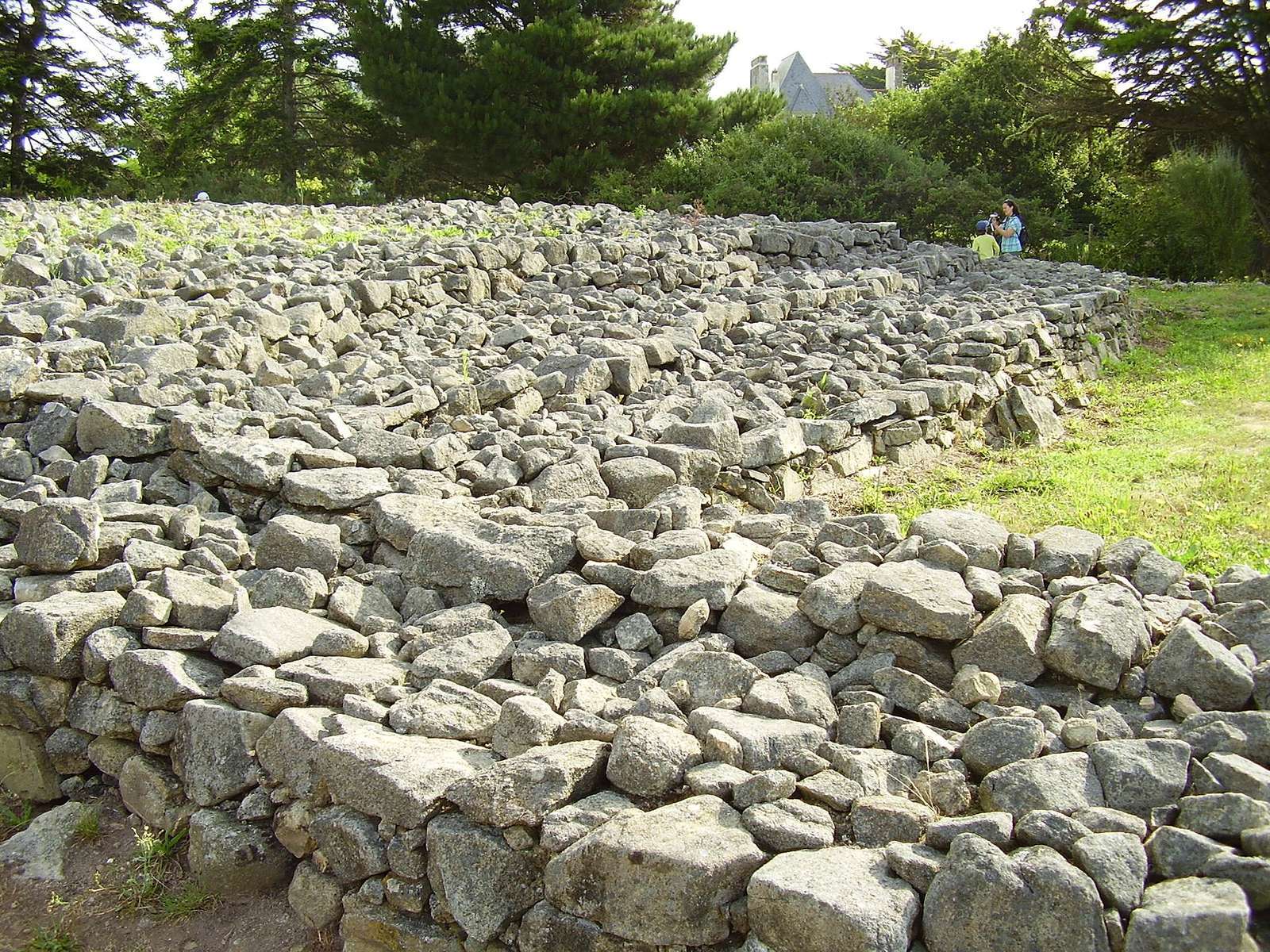
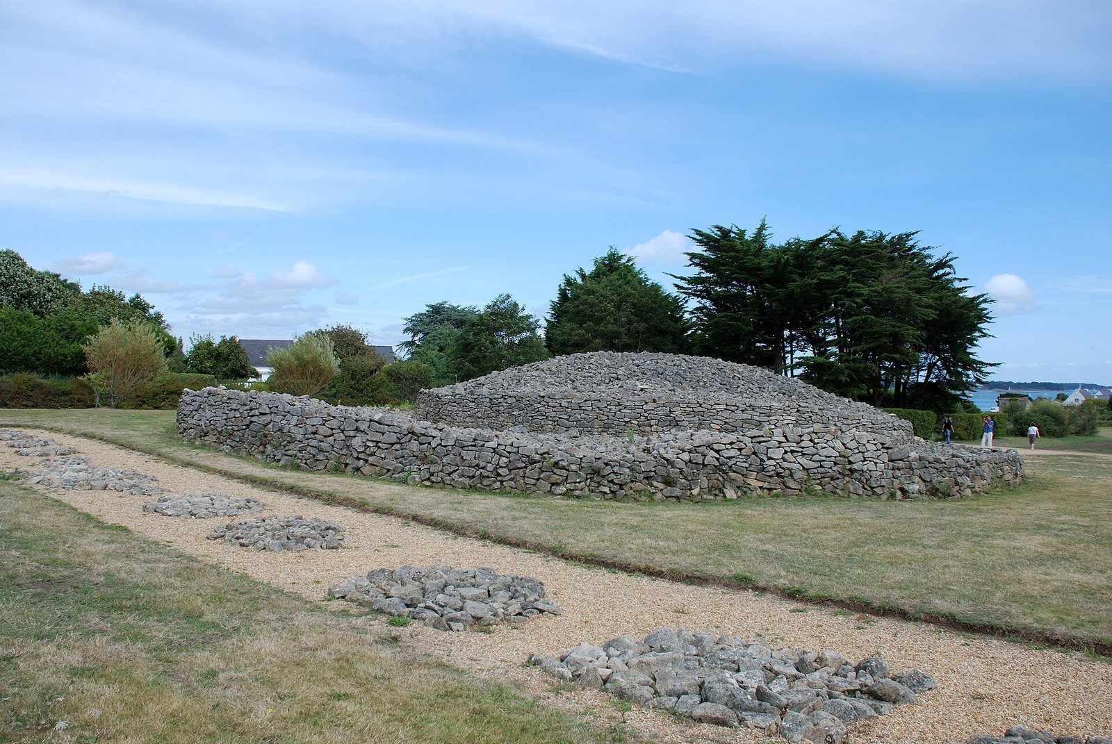
The surviving monument is a trapezoidal, exceptionally elongated tumulus about 140 metres long and between approximately 16 and 26 metres wide. Its construction developed from a small funerary chamber and circular cairn into a broader trapezoidal mound, followed by long north-south extensions. Most of the stone is local granite, while the chamber’s large cover slab is orthogneiss.
The burial chamber and cairns
Burial chamber
The earliest funerary structure was a trapezoidal chamber set into a depression in the bedrock. Dry-stone walls and two vertical slabs reinforced its sides, and the chamber had a paved floor. It measured about 4 metres long, 2.60 metres wide at the western end, and 1.80 metres wide at the eastern end.
A large orthogneiss slab covered the chamber. It measures approximately 3.85 by 3.15 metres and is about 70 centimetres thick. The slab may have been produced by cutting down an earlier menhir from the nearby Grand Menhir alignment. Larger pieces of the same stone are reported as cover slabs at the Table des Marchand and the dolmen of Gavrinis. The dolmen is an unusually rare closed individual megalithic tomb. Its stones bear no ornamentation, and no stones indicating a megalith-lined or megalith-covered entrance have been found.
Circular and trapezoidal cairns
The chamber was enclosed within a circular cairn about 10 metres in diameter. It had two facing walls and an opening toward the east, although its original height is unknown. A second phase incorporated this structure into a trapezoidal cairn measuring about 45 metres long and 20 metres wide. Built exclusively from granite rubble, the second cairn was constructed in two stages, with the later stage blocking access to the chamber.
The elongated extensions
Northern extension
The final building phase added northern and southern extensions with a combined length of about 80 metres. They gave the monument its long north-south form. The northern extension has disappeared through quarrying and other extraction, although earlier investigations described its end as intact before the twentieth-century quarrying.
Southern extension
The southern extension ended at the foot of the Grand Menhir brisé d’Er Grah. An angular granite block marked its south-west corner, and a fragment of an orthogneiss slab was reused in its facing. The extension had a compacted core of fine silt or earth, strengthened internally by an interlaced wooden framework called wattle and supported outside by faced masses of rubble and stone. It may have stood no more than 2 metres high, allowing the chamber’s cover slab to remain visible above the surface.
Surviving structure
Only parts of the stepped lower foundations and rubble-stone facing survive. The main body was formed largely from earth, probably supplemented or covered by small stones. The surviving fabric therefore preserves the monument’s changing construction methods, from the stone-built chamber and cairns to the earth-supported extensions, while quarrying, extraction, levelling, and later restoration have shaped its present form.