Tanais: An Ancient Greek Trading City in the Don Delta
Site at a Glance
- Popularity
- Very High
- Country
- Russia
- Primary era
- Classical
- Eras represented
- Classical, Medieval
- Civilizations
- Ancient Greek, Bosporan Kingdom
- Site type
- City
On this page19 sections
History
Foundation and Hellenistic trade
Tanais was an ancient Greek trading city near Nedvigovka in Rostov Oblast, Russia. Greeks connected with the Bosporan sphere founded it in the first quarter of the third century BC. The Bosporan Kingdom was an ancient state around the Black Sea and Sea of Azov. Tanais became an emporion, or trading settlement, at the northeastern edge of the Greek world. The geographer Strabo described it as a meeting place for Greek merchants and nomadic peoples from Asia and Europe. A much earlier Greek trading or fishing settlement submerged in Taganrog Bay has been proposed as an earlier Tanais, but the identification remains disputed.
Early imports included wine and olive oil carried in large storage jars, especially from Rhodes and Sinope, as well as from other Black Sea and Aegean centers. Beads and everyday tableware were common, while glassware, metal vessels, jewelry, and brooches were rarer. Stamped handles from 431 imported jars recovered in excavations between 1955 and 1960 include 398 from Rhodes and 17 from Sinope. Rhodian imports began arriving in the first half of the third century BC. Their volume peaked around 220–180 BC and again in the second quarter of the second century BC, before falling sharply late in that century. Wider growth in imported pottery and jar traffic came by the late first century BC or early first century AD, as settled Maeotian communities, peoples of the Sea of Azov region, developed around the city.
Political ties between Tanais and the Bosporan Kingdom before the first century BC remain uncertain. The city may have been annexed during that century, perhaps under Polemon I, king of Pontus and the Bosporan Kingdom. Strabo also reported that some Maeotian communities were subject to the holders of the Tanais trading center, suggesting authority beyond the settlement itself.
The Roman-period city
Around 8 BC, Polemon I sacked Tanais after its inhabitants refused his authority. The city’s western district was burned and its defensive walls dismantled. Domestic and commercial building resumed, although the defenses remained in ruins for about a century. Queen Dynamis of the Bosporan Kingdom may have helped the city recover. A monumental dedication made in the name of the people of the trading settlement calls her a savior and benefactress.
Commercial activity revived during the Roman period. Goods reached Tanais from the eastern Mediterranean, southeastern Asia Minor, and some western Mediterranean and North African centers. Asia Minor pottery with a red surface coating was prominent, while gray, polished pottery from the central Caucasus arrived in the second and third centuries AD. Trade with steppe communities included luxury bronze and silver vessels and brooches. Strabo named enslaved people and hides among the city’s exports; fish and fish products may also have been sold. Inscriptions show a civic council headed by presiding officials and two communities, the Hellenes and the Tanaitai, each with its own officials. Their precise social or ethnic distinction remains debated. A royal representative from Panticapaeum oversaw civic institutions and their allegiance to the Bosporan crown.
Inscriptions generally call the civic body the “Emporion,” rather than using Tanais as the city’s official name. The title translated as “magistrate of the Tanaitai” applied to that community, not to the whole city. Inscriptions from the second and third centuries AD also show a substantial presence of people with Iranian names. The city was badly damaged in the mid-second century AD, during the movement of late Sarmatian groups, Iranian-speaking peoples of the Eurasian steppe, into the Lower Don region. It was rebuilt relatively quickly, and Iranian names became more frequent in inscriptions.
Late Antiquity and later occupation
Tanais suffered further destruction in the mid-third century AD, commonly attributed to the Goths, a Germanic people. Another severe devastation took place in AD 330, and a further destruction horizon belongs to the mid-fourth century. After a period of decline, building and trade revived in the second half of the fourth century. The settlement extended east beyond its earlier ditch; houses were rebuilt over older structures, and streets and public spaces were relaid.
In the early fifth century the inhabited area contracted sharply, and residents left the Lower City. Some belongings appear to have been left behind in haste, but the abandonment was not accompanied by clear evidence of destruction. It was complete by the second half of the fifth century. The wider effects of the Hunnic invasions, carried out by a nomadic confederation, may have contributed, as did changes in the river channel and the eastward movement of activity in the delta. A separate community, conventionally called the Western Nedvigovka settlement, occupied part of the site from the sixth through ninth centuries. Its residents lived in settled houses, though its extent, economic connections, and eventual abandonment remain uncertain.
The medieval Italian trading colony of Tana inherited the ancient city’s name but stood at modern Azov, not at the ruins near Nedvigovka. It took shape in the second half of the thirteenth century and was conquered by the Ottomans in 1471.
Rediscovery and archaeological work
I. A. Stempkovsky connected the ruins near Nedvigovka with ancient Tanais in 1823–24. Pavel Leontiev’s excavations in 1853 confirmed the identification through inscriptions and other finds, but poor recording and damage to the site marked this early work. Stone was also taken from the ruins for decades. Later investigations included work by V. G. Tiesenhausen, P. I. Khitsunov, and Nikolai Veselovsky.
Systematic excavation began in 1955 with the Lower Don Archaeological Expedition, initially led by Dmitry Shelov. T. M. Arsen’eva took over in 1973, followed by Sergey Ilyashenko in 2012. Excavations revealed parts of the Citadel, cemetery, western districts, Lower City, and defensive ditches. By 1970, work had covered several thousand square metres and more than 250 graves. Tanais and its cemetery became a protected archaeological reserve in 1959, and an archaeological museum-reserve opened there in 1961. The property has federal-level cultural heritage status in Russia. Norwegian explorer Thor Heyerdahl also advanced a controversial connection between Tanais and ancient Scandinavia, drawing on medieval Scandinavian sagas while preparing a book.
Remains
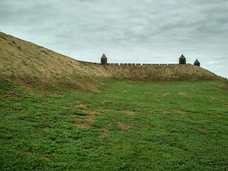
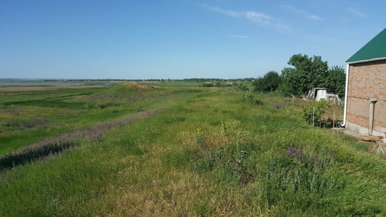
The ruins occupy a limestone terrace on the high right bank of the Mertvy Donets, the northernmost arm of the Don delta. Natural rock lies close to the surface; deep gullies border the terrace to the east and west, a ditch bounds it to the north, and the ground drops as much as 20 metres to the south. The fortified central area, known as the Citadel, stood on a higher terrace, while the Lower City extended across a lower river terrace and floodplain. The river channel is considered to have been the Don’s main course during the city’s occupation. The site is now about 10 kilometres from the sea. Shelov proposed that the western delta had not yet formed in antiquity and that Tanais then stood at the river mouth, a reconstruction of the changing landscape.
Fortifications and entrances
The Citadel and district walls
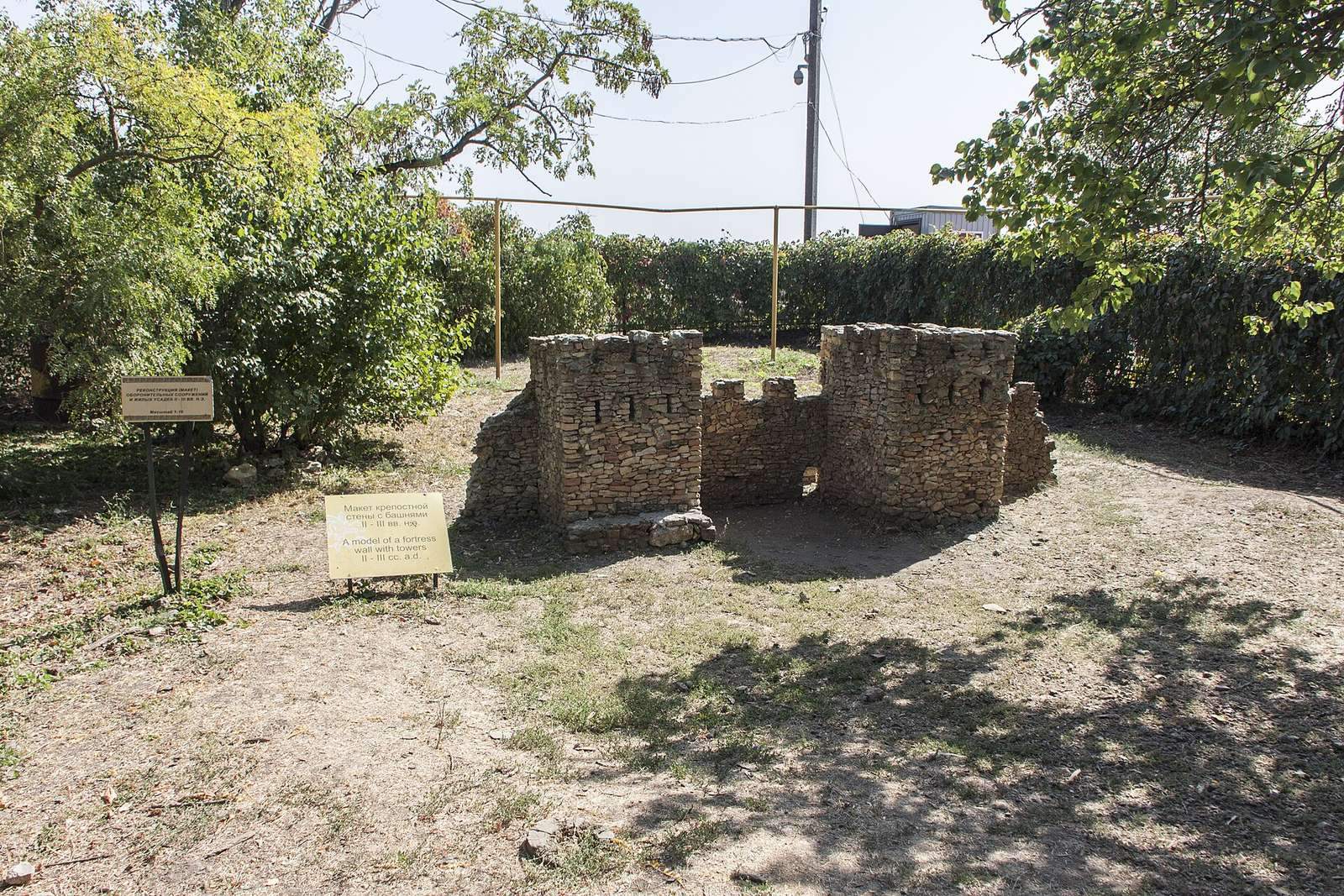
The central enclosure was nearly square, with sides roughly 225 to 240 metres long, and its alignment lay about 10 degrees off the cardinal directions. Other measurements give dimensions of 280 by 270 metres for an early phase and 240 by 250 metres in the first through third centuries AD. In the second and first centuries BC, the settlement extended 600 to 700 metres along the riverbank. Limestone walls enclosed the Citadel, built with two outer faces and a rubble core. They reached about 3 metres thick and included rectangular towers. Stone projectiles found inside one tower suggest that a stone-throwing engine may have been part of its defenses.
Wall 5 separated the eastern and western districts. Built in the late third or early second century BC, it was about 2.4 metres thick and survives to a height of 3.75 metres. Its rectangular tower had dressed blocks, some with roughened surfaces, at the corners and doorway. The tower collapsed soon after it was built and was roughly reconstructed in the second century BC. The northern and western walls of the Western District were about 3 metres thick, with stone faces and rubble cores. They were dismantled for building stone around the turn of the era; rubbish accumulated over their remains during the first century AD, and a house was later built along the wall line.
Defensive ditches
Hellenistic defenses included dry ditches with a combined length exceeding 1,000 metres. They were up to 13–14 metres wide, as much as 3 metres deep from the base of the wall, and 2.6–3.7 metres wide at the bottom. Some sections were cut into bedrock. Near the western gate, a ditch turned west to protect the Western District and suburb. Early descriptions place an earth rampart along the outside of a broad defensive strip, up to about 215 metres wide, which extended around three sides of the settlement.
In the Roman period, builders added new outer stone faces to older walls. One western stretch increased in thickness from about 2.2 to 3.1 metres, and reconstructed towers may have reached 17–19 metres. A rebuilt ditch, probably protecting the Citadel, was about 7–8 metres deep, up to 21 metres wide at the top, and 6–6.5 metres wide at the bottom. In Late Antiquity, residents made use of surviving defenses. The partly filled ditch was crossed diagonally by a stone-and-pottery causeway about 2 metres wide, leading toward a small gate in the western enclosure.
Gates and approaches
Excavations have exposed gates on the western and southern sides of the Citadel, as well as an opening in the Western District. The western district gate was up to 1.7 metres wide. Stone supports across its ditch indicate that a wooden bridge stood there in the second or first century BC. The approach met the defensive wall at an angle rather than running straight toward it. A gate once called the “south gate” in archaeological writing has been identified as a second opening in the north wall.
The southern Citadel gate was built in AD 108. A limestone inscription records its construction and identifies the Hellenarch, an official associated with the Greek community, as Zenon’s son. A separate inscription fragment bearing the name of the architect Diophantus son of Neopolus dates to AD 212 and was found near the gate.
Districts and civic spaces
Eastern and western districts
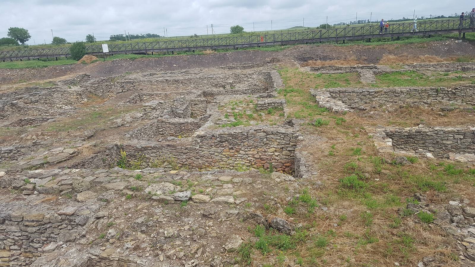
The eastern district occupied a plateau later enclosed by the central quadrangle. Its surviving Hellenistic remains have a regular plan, with straight lanes and orderly building walls. Beyond the dividing wall, the Western District covered more than 1,000 square metres. Its stone houses were set at varying angles around small paved courtyards, with winding passages about 1–2 metres wide. Archaeologists also identified a western suburb.
The Lower City and later houses
The Lower City spread over the first river terrace and floodplain, below the Citadel’s second terrace. In the later fourth century, houses and utility buildings were laid over earlier foundations. New streets crossed older streets and squares. The first rebuilding level includes rectangular buildings made from unworked stone taken from earlier ruins.
Houses in the Western Nedvigovka settlement ranged from round to square and roughly rectangular plans. Their limestone walls were probably built with stone from the Citadel ruins. Floors were level and measured 6–12 centimetres thick; the archaeological layer associated with these houses reaches about a metre in depth.
Water, storage, and the agora
Cellars, cisterns, and grain pits were cut directly into the bedrock of the central limestone terrace. Some excavated grain pits held more than 12 cubic metres. A paved square in the western district, dating to about 100 BC, had a stone water channel, collecting cistern, and well.
A monumental entrance to the agora, the city’s public and commercial center, was built in the Roman period. Blocks from the structure, including pieces of a dedication to Dynamis and a decree honoring the son of Mathianes, were reused in fourth-century houses above its ruins. One alternative reconstruction proposes that a gate between the port area and the agora was removed and a palatial residence took the place of the former public space.
Cemetery, religious features, and finds
The cemetery
The cemetery lay outside the city walls, mainly to the east, and covered a larger area than the settlement. Fewer than 50 graves from the third through first centuries BC have been excavated. Nearly all were simple earth pits at least 2 metres deep, containing burials in which the dead were placed in the ground, as well as a few cremations. Grave goods included pottery with food offerings, perfume flasks, jewelry, boxes, scissors, needles, spinning tools, mirrors, clothing fittings, and, in some graves, weapons. Finds include fourth-century earrings and second-century pendants.
Religious remains
Religious finds include terracotta figures of Demeter, Tyche, Eros and Psyche, and Aphrodite holding a mirror and an apple, as well as bronze figures of Apollo, Hermes, and Silenus. Inscriptions record dedications to Zeus, Ares, Aphrodite, Apollo, and Artemis. Other evidence includes a cult of the river god Tanais, groups devoted to Theos Hypsistos, meaning “Highest God,” and worship of Aphrodite Ourania, an aspect of the goddess associated with the heavens.
Two cellars have been identified as places of worship. One contained clay stamp seals; another was filled before a mid-fourth-century destruction and held the remains of 18 buried rams and a terracotta eagle. A separate cellar yielded a large stone altar, lamps, and stamps used to make ritual cakes. Small fired-clay altars, some coated with glaze, bear evidence of offerings of oil and wine. Incense burners were also used in burial rituals.
Inscriptions and other objects
Excavated finds include three fragments of a limestone building-inscription slab and a marble stele depicting a mounted horseman identified as Tryphon, son of Andromenes. Other objects include catapult stones, pottery and glass vessels, and coins of Sauromates II and Rescuporis III. A second-century BC lion-head earring and a carved stone table support came from the Citadel. A lead wearable cross of a type found in the late antique Christian world was recovered from a room in the settlement.
Workshops and household production
Building was the most extensive craft activity. Pottery kilns, glassmaking waste and molds, bone-working debris, and tools for woodworking provide evidence of other local production. A clay ladle still containing glass and fragments of vessels are among the remains associated with glassmaking. Bone and horn workers made objects such as awls, tubes, knife handles, bow fittings, and arrowheads; local pottery was formed by hand rather than on a wheel.
Spinning and weaving are represented by spindle whorls and loom weights, most made from unfired clay and some from stone. Some spindle whorls were fashioned from the feet of imported storage jars and fragments of vessels. These tools, together with the settlement’s workshops and household remains, reflect a range of craft activities carried out at Tanais.