Tamtoc: A Huastec Urban and Ceremonial Center in Mexico
Site at a Glance
- Rating
- 4.7
- Popularity
- Low
- Country
- Mexico
- Primary era
- Medieval
- Eras represented
- Iron Age, Medieval
- Civilizations
- Huastec
- Site type
- City
On this page21 sections
History
Tamtoc is a Huastec urban and ceremonial center in Ciudad Valles, San Luis Potosí, Mexico, whose earliest known development began around 600 BC. Built within the Huasteca region by a Mesoamerican cultural group whose homeland lay in northeastern Mexico, the city eventually covered about 210 hectares and became an important regional center for political authority, commerce, warfare, and ritual life.
Early development and cultural change
Archaeologists have identified at least three major occupation phases. The first began around 600 BC, when the city emerged beside the Tampaón River. The river supported farming, hunting, gathering, exchange, and contact with other regions. The surrounding plains and mountains also shaped the city’s ritual outlook, since prominent landforms served as references for celestial events and influenced the arrangement of urban spaces.
A second phase, dated approximately from AD 600 to 900, brought a cultural influence not previously recognized at Tamtoc. This change reshaped the urban plan and strengthened the city’s regional leadership. Circular structures from this period were later covered by new construction, especially in the central area.
The final identified occupation phase, from approximately AD 900 to 1350, brought substantial population growth and intensive building. The scale and organization of construction point to a society that had become more powerful and socially complex. Earlier interpretations placed the city’s main florescence in the Postclassic period, the later phase of Mesoamerican history immediately before the Spanish conquest. Finds linked especially to Monument 32 have instead raised the possibility of an earlier florescence around 600 BC, during the Preclassic, the period preceding the rise of many major urban states. The exact chronology remains debated, and the city’s eventual abandonment is also placed in the sixteenth century.
Regional authority and religious life
By the end of its last major phase, Tamtoc had lost its regional hegemony for reasons that remain unknown. Its development had continued for centuries before the arrival of the Spanish. The city’s archaeological record gives unusual prominence to women. Around 90 percent of the excavated burials are female, and women appear in most of the clay and ceramic figurines. These patterns may indicate that women held elevated social positions in the community.
Tamtoc also retained religious importance for Teenek communities, the modern name used by Huastec peoples for themselves. People continued to bury their dead at the site until the 1930s. Indigenous communities, principally Teenek groups, still gather there in November for the two-day Procession of Spirits, when dances are performed and offerings are made in memory of ancestors.
The ancient city has been associated with proposed cultural links between the Huastecs, earlier Mesoamerican traditions, and later migration routes toward the central highlands. These connections remain interpretive rather than settled conclusions. No Aztec ceramics have been found to support the idea that the Mexica conquered Tamtoc. The early date and distinctive character of Monument 32 have also led to the possibility of an earlier Olmec presence in the region. The Olmecs were an early Mesoamerican civilization associated especially with the Gulf Coast and monumental stone sculpture, but the proposed connection is not certain.
Exploration and archaeological work
Knowledge of the pre-Columbian remains existed by the late nineteenth century. Joaquín Meade explored Tamtoc in the late 1930s, and investigations expanded during the 1960s. Professional research, excavation, recovery, conservation, and improvement projects have continued since 2000. Estela Martínez Mora has directed studies at the site, while Guillermo Ahuja O. was an important promoter of expanded work from the beginning of the twenty-first century.
The National Institute of Anthropology and History, Mexico’s federal institution for archaeological research, conservation, and heritage protection, receives many of the artifacts recovered during continuing excavations for study and storage in Mexico City. Ceramics, masks, funerary remains, tools, weapons, and other materials remain in institutional storage rather than in a dedicated museum at Tamtoc. The archaeological area opened to the public on May 11, 2006. Research, conservation, and presentation of the ruins have been supported by the Trust for the Archaeological Rescue of Tamtoc, involving Fomento Cultural Banamex, the Government of San Luis Potosí, and the National Institute of Anthropology and History.
Remains
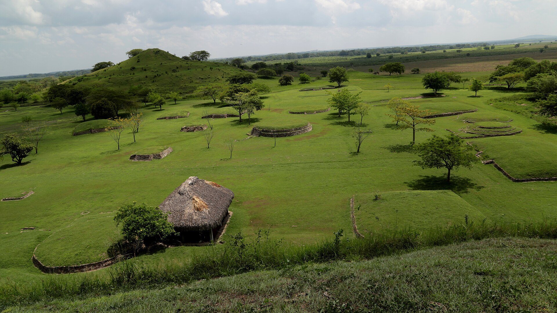
Tamtoc occupies the Tamuín plain within a bend of the Tampaón River, on the river’s northeastern bank in the Pánuco drainage system. The low-lying landscape is vulnerable to flooding, so the city was built largely from earth, using natural rises and extensive artificial platforms. More than seventy structures have been mapped and recorded, with approximately thirty within the area open to visitors.
Urban organization and water management
The city was arranged around raised multifunctional platforms that supported civic, religious, and residential complexes. Ordinary houses stood on higher ground near the platforms and on neighboring rises, where small terraces also supported rooms and gardens. River landings connected the settlement to commerce and movement along the Tampaón. Ramps and stepped embankments led upward from the water toward spaces with increasingly restricted access, including markets, religious gathering places, and areas for political or administrative meetings. Plazas hosted public ceremonies, civic events, and the exchange of local and imported goods.
Four excavated or altered lagoons surrounded the ceremonial areas: the North Lagoon, the Great Lagoon of the Ducks, the Ceiba Lagoon, and the South Lagoon. Some were used for aquaculture. Hydrological and topographical studies showed that the Great Lagoon of the Ducks was an artificial basin built in part to regulate flooding from the Tampaón River. Objects connected with offerings were recovered during desilting and restoration work, which required limiting the use of heavy machinery.
Central and residential groups
Main Plaza
The Main Plaza was probably a civic and administrative center built during the final major occupation phase. Its group contains twenty-three structures, with eighteen arranged around the plaza and five in its central area. Most are interpreted as platforms for elite residences. Nearly all had stairways leading to upper levels occupied by a temple or residential complex. Structure AW3 is understood as a small altar. Structures AC1, AC2, and AW3 each contained human burials and two anthropomorphic twin stelae, upright carved stones representing human or human-like figures, placed as offerings.
The Main Plaza preserves at least two building phases. The earlier phase, dated approximately from AD 600 to 900, included circular buildings that were largely concealed by later work. The structures visible today mainly belong to the final phase, dated approximately from AD 900 to 1350.
Northeast Plaza
The Northeast Plaza group consists of ten mounds, nine arranged around a plaza and one positioned separately to the north. The group is associated with residential activity and textile production. Remains of murals in red, orange, blue, and green survive on structures in this sector.
Corcovado
The Corcovado is a circular structure interpreted as a center for commercial and political activity. It formed part of a city marked by large earthen pyramidal platforms, some more than twenty meters high, with a broad plaza and additional circular buildings between them. The upper sections of those circular buildings were made from perishable materials and have disappeared.
North Set and La Noria
North Set
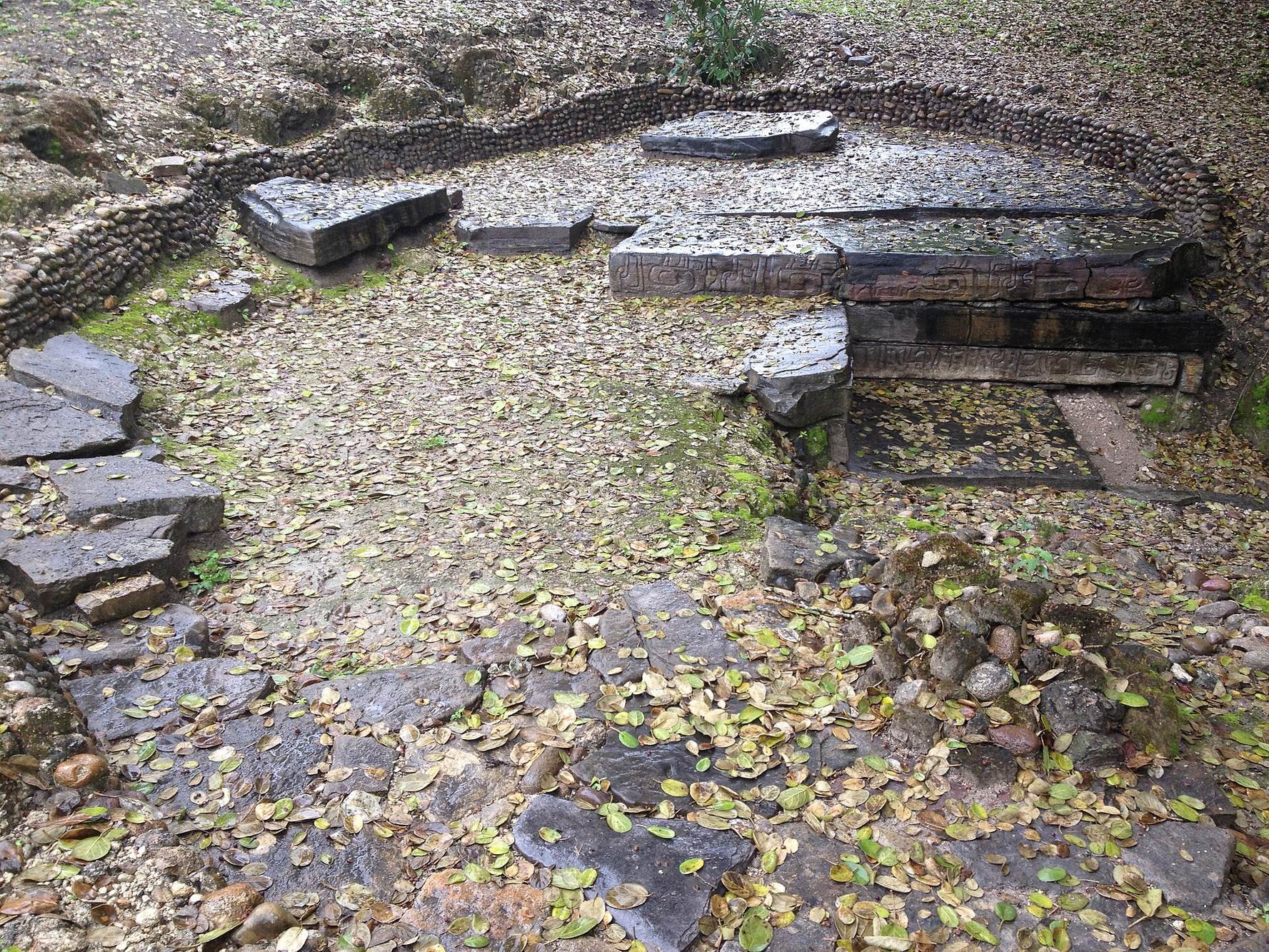
The North Set contains several structures and produced the Tombstone of the Flamingos, the Giant, the Castrillón Stela, the Venus of Tamtoc, and Monument 32, also called the Priestess. Springs in this area supplied an ancient channel network that carried water through the sector before emptying into the Great Lagoon of the Ducks. At the foot of structure C3, excavation revealed a workshop where necklace beads and other ornaments were made.
La Noria
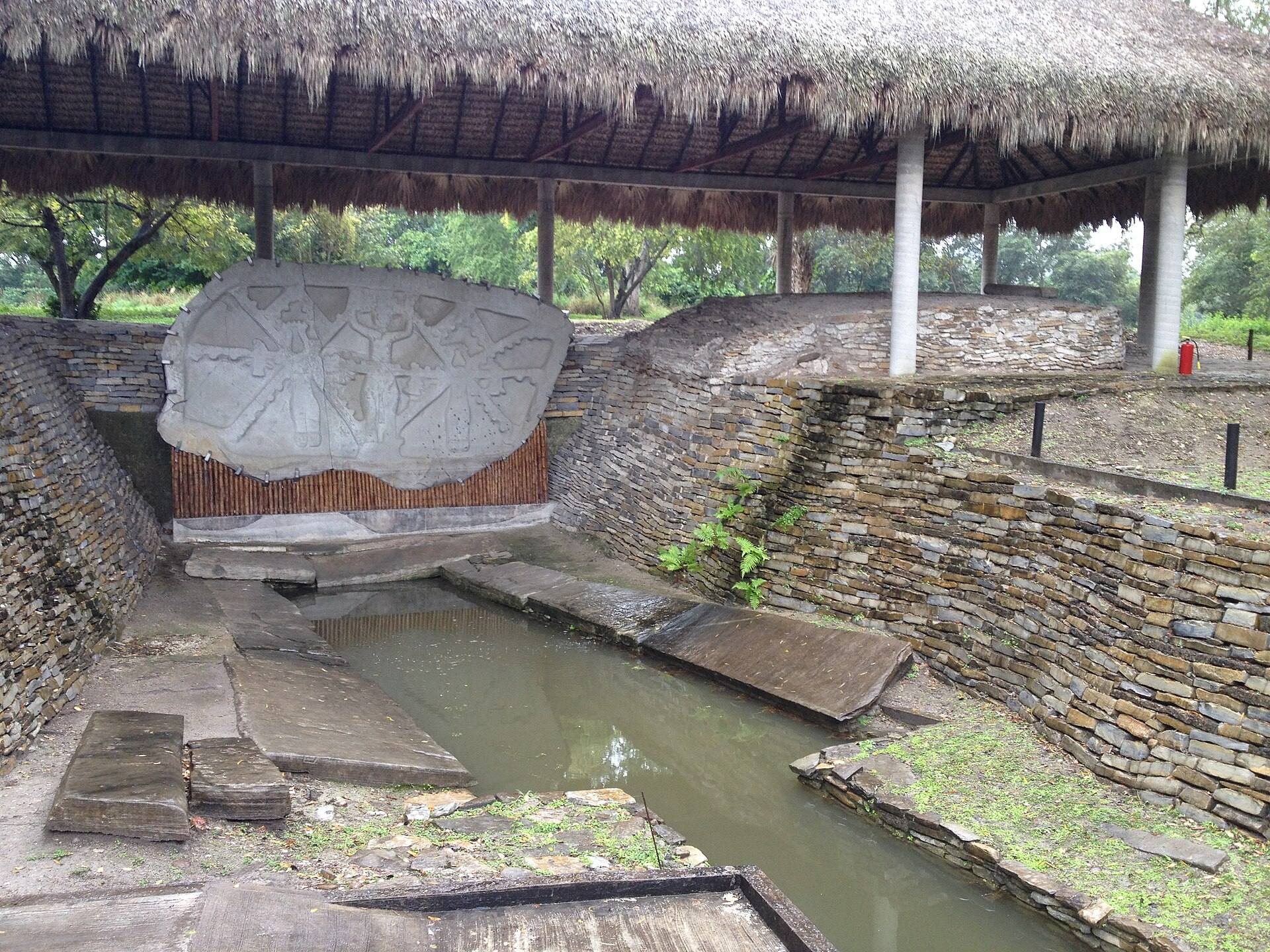
La Noria, or the Water Box, forms part of the North Set and preserves several successive uses. During the earliest occupation, beginning around 600 BC, its spring and channels formed a sacred place associated with the city’s origin. Offerings, including Monument 32, were recovered there. From approximately AD 600 to 900, the area was redirected toward everyday activities, and two excavated ovens may have been used for processing food.
During the final occupation phase, approximately AD 900 to 1350, new buildings, temples, walkways, and open spaces transformed La Noria into a setting for religious ceremonies and sacred practices. A group of funerary mounds yielded about seventy skeletons of people of different ages and sexes. Examination of these remains found severe infections, bone deformities, and other signs of disease. A population with this particular pattern of pathology has so far been identified only in this part of Tamtoc.
Monument 32
Monument 32, known as the Priestess, is a monolith, meaning a monument carved from one block of stone, interpreted as a lunar calendar. It is made of polymineral sandstone, a sandstone containing several mineral components, and measures about eight meters long, four meters high, and half a meter thick. Its weight exceeds thirty tons. Its date is uncertain, with estimates ranging from approximately 1150 to 700 BC, and its form has been tentatively connected with the Olmec tradition.
The monument was discovered by chance in February 2005 during the restoration of a water channel leading from a spring to an artificial lagoon. It was removed in November 2006. Rain, exposure, and standing water had begun to damage the stone, prompting intensive conservation at La Noria. Work has also been undertaken on the nearby lagoon to preserve the setting in which the monument was found.
Venus of Tamtoc
The Scarred Woman, also called the Venus of Tamtoc, is a fragmented, life-size female sculpture discovered in 2005 during work connected with Monument 32. It had remained underwater for more than 2,500 years and is dated to approximately 600 BC. The decapitated figure is carved from basalt, a stone not found locally. Its fragmentation has been interpreted as a ritual substitute for human sacrifice and as an act intended to promote fertility after the sculpture was placed in a water deposit.
Raised marks resembling tattoos cover the shoulders, breasts, and thighs. These have been interpreted as references to the 52-year Mesoamerican calendar cycle and to 104-year lunar and solar cycles. The figure may represent a priestess rather than a goddess, an interpretation that connects the monument with the ritual and social importance of women as bearers of time.
Monumental platforms and astronomical associations
Paso Bayo
The structure called Paso Bayo, or Tamtoque, rises about 21 meters and is the second tallest structure at Tamtoc. It marks the eastern edge of the monumental area. Its elevated platform probably supported an important temple where ceremonies connected with measuring time and observing the movement of celestial bodies may have taken place.
Western platform
The large western platform, formerly called El Tizate, reaches about 36 meters in height and has a stairway on its front. A temple once stood on the summit, which marked the western boundary of the monumental zone. The platform is associated with astronomical observation and Huastec cosmology. Its name comes from a nearby riverbank deposit of crystallized carbonates or volcanic ash called tizate, a material used in making ceramics.
Sculpture and craft production
Monument 22
Monument 22, known as the Ruler, Cinco Caracol, or Tomás, preserves the lower portion of a male figure carved in stone. The hand may have been shaped to hold a staff of office. Inscriptions have led to the tentative interpretation that the sculpture represented an important ruler, possibly a person called Cinco Caracol. Its nudity has been connected with fertility and phallic ritual practices.
Sculptural workshops
Several stoneworking workshops have been identified around La Noria. One produced part of a zoomorphic stela showing human legs that end in bird claws. The fragment is approximately one meter high, 1.5 meters wide, and weighs about ninety kilograms. These workshops and related stoneworking evidence point to highly specialized artists at Tamtoc. Sandstone from the Sierra de Tanchipa was used for images of rulers, priestesses, and public stelae, while green stone, or tinguaíta, from Cerro del Murciélago was shaped into ornaments and utilitarian objects.
Other excavated materials include finely decorated household vessels, ceramics deposited as offerings in the Great Lagoon of the Ducks, and pottery placed with burials. Together with masks, tools, weapons, and funerary remains, these objects illuminate the city’s domestic, ritual, and mortuary activities, while remaining in the care of the National Institute of Anthropology and History rather than on display in a site museum.