San Lorenzo Tenochtitlán: A Major Olmec Archaeological Complex in Veracruz
Site at a Glance
- Popularity
- Very High
- Country
- Mexico
- Primary era
- Iron Age
- Eras represented
- Bronze Age, Iron Age
- Civilizations
- Olmec
- Site type
- Settlement
- Remains
- City
On this page19 sections
History
San Lorenzo Tenochtitlán is a group of three related archaeological centers built by the Olmec, an early Mesoamerican civilization, in southeastern Veracruz, Mexico. Its principal center, San Lorenzo, flourished as a leading Olmec center from about 1400 to 900 BCE. Matthew Stirling coined the collective name in 1955, using nearby village names. The site’s original Olmec name is unknown, and it is not Tenochtitlan, the later Aztec capital on the site of modern Mexico City.
Early occupation and growth
Occupation began by the middle of the second millennium BCE. Radiocarbon dates from Ann Cyphers’s excavations place activity at around 1700 BCE. The sequence of archaeological phases runs from Ojochi and Bajío through Chicharras, San Lorenzo, Nacaste, Palangana, and Remplás. These names distinguish successive periods partly through changes in settlement and material culture.
A village existed during Ojochi, and the population grew in the Bajío phase. Monumental sculpture appeared in Chicharras, alongside a major change in pottery. San Lorenzo reached its height in the phase that bears its name, becoming a major center by about 1400 BCE.
Regional center and cultural connections
San Lorenzo was one of the principal Olmec centers, alongside La Venta and Tres Zapotes. From roughly 1200 to 900 BCE, it was the largest city in Mesoamerica. It was also the earliest Olmec site to display state-level complexity, meaning organized political authority and distinct social ranks. Its political influence reached across much or all of the Coatzacoalcos basin and helped spread Olmec culture. Independent political communities may have occupied areas to the east and north-northwest.
The center served mainly ceremonial purposes within a wider, substantially agricultural population. Estimates suggest that its ceremonial precinct and associated buildings could accommodate about 5,500 people, while the wider settlement and hinterland may have supported as many as 13,000. Residents cultivated maize and ate domestic dog, several kinds of fish, and turtles. For a 77-square-kilometer study area, one estimate puts annual maize production at about 500 metric tons, enough to feed roughly 5,556 people.
Olmec-style pottery and figurines from the San Lorenzo area circulated elsewhere in Mesoamerica, including to Canton Corralito on the coast of Chiapas. More than 5,000 early Olmec-style objects were found there, with more material assigned to the Initial and Early Olmec periods than in the San Lorenzo area. In the Cuadros phase, imports from San Lorenzo made up 15 percent of the Calzadas Carved pottery and 9 percent of the Limón Incised pottery at Canton Corralito.
Decline and later occupation
San Lorenzo began to decline around 900 BCE as La Venta overtook it. By about 800 BCE, few or no people remained at the site. The cause and course of this decline are uncertain. Suggested factors include conflict, environmental and economic changes, the rise of rival centers, altered river courses, and tectonic activity in the Los Tuxtlas area. Damaged monuments were once interpreted as evidence of revolt or conquest; another interpretation holds that they had been carved again and reused repeatedly before the center collapsed.
Population fell during the Nacaste phase, which had a different pottery style. In Palangana, the settlement had contracted to about 20 hectares and a group of mounds was built; whether San Lorenzo was then subordinate to La Venta remains uncertain. Population declined further in Remplás. A further recolonization of the plateau is dated to about 600–400 BCE. Although the surrounding area was occupied during the Early and Middle Classic periods, a later return to San Lorenzo itself is associated with the Villa Alta phase, around 800–1000 CE.
Archaeological investigation
Stirling visited San Lorenzo in 1938, and excavations began in the 1940s. He and Philip Drucker excavated there in 1945. Further projects ran between 1946 and 1970, including Michael Coe’s investigation, begun in 1964, and a Yale University study led by Coe and Richard Diehl in 1966–1968. Alfonso Medellín Zenil identified basalt quarries in the Tuxtla Mountains in 1960. Work from 1990 to 1996 examined settlement patterns at local and regional scales and uncovered additional sculptures; the tenth known colossal head was found in May 1994. A museum near San Lorenzo opened in 1995 to display that head and other finds. In the 1980s, researchers also identified an astronomical relationship between San Lorenzo, Zempoaltépetl volcano, and the winter solstice, the shortest day of the year in a hemisphere.
Remains
The archaeological complex combines a reshaped plateau with settlements on nearby high ground, monumental stonework, residential terraces, and water-control features. At San Lorenzo, the plateau summit and slopes formed the main built area, while related centers occupied other parts of the surrounding landscape.
Plateau and surrounding centers
San Lorenzo plateau
San Lorenzo proper occupies the summit and slopes of a plateau about 50 meters above the floodplain. Built on high ground between active tributaries, it is about 1.2 kilometers long and 600–700 meters wide. Its surface was extensively filled and leveled. The core covers roughly 55 hectares; estimates for the broader plateau or occupied area reach 700 hectares, while the settlement is estimated to have extended across about 500 hectares at its height. One estimate places the volume of earth fill between 500,000 and 2,000,000 cubic meters, moved in baskets. Six ridges divided by ravines formed part of the planned layout.
Related centers and sites
The three centers lie near the Coatzacoalcos River basin, about 60 kilometers from the Gulf of Mexico. Tenochtitlán sits at the northern end of the island where the centers were grouped, within the modern village of the same name. Potrero Nuevo occupies a hill east of the plateau. South of San Lorenzo, the Loma del Zapote ridge extends toward El Azuzul at its southern tip.
Water management and landscape features
Drainage channels
Buried channels made from carefully fitted, U-shaped stones carried water toward the plateau’s edges. Their slope was about 2 percent. Springs supplied fresh water on the raised ground, where it was more readily available than in the lowlands. The channels served drainage and water-supply functions and may also have had a ritual purpose.
Ponds, ball court, and river barriers
Ponds occur around the site. Some have been interpreted as artificial, though their age and origin remain disputed. A ball court was also present. Causeways or dikes altered the surrounding landscape. The two largest bordered ancient river courses at Potrero Nuevo and El Azuzul; they may have helped control floods and may also have served as wharves for loading and unloading canoes.
Monumental sculpture
Colossal heads and thrones
Monumental sculptures and large thrones were concentrated on the plateau summit, with many in its western section. At least ten colossal heads and several thrones formed ritual alignments. The heads are thought to represent rulers. They stand about 1.65–3.4 meters high and weigh roughly 6–28 metric tons. Their production is estimated to have taken place over 100–150 years. The sculptors used basalt from Cerro Cintepec volcano in the Tuxtla Mountains. The stone came from volcanic blocks or boulders thought to have been ejected from the mountains about eight million years ago. The known colossal heads are displayed in museums in Mexico.
Other stone works and small finds
Up to 124 stone sculptures have been found. They include a head resembling an upright stone monument, as well as a seated human-jaguar figure wearing a headdress and chest shield. Other sculptures show human figures and supernatural beings. Some altar-like thrones have a human figure carved on the front. These works expressed sacred authority and the rulers’ ability to organize the labor and transport needed to produce them.
Hundreds of thousands of small ilmenite pieces, an iron-titanium oxide mineral, have also been found. They are about 1.5 centimeters long and usually drilled with three holes; their purpose is uncertain.
Buildings and domestic areas
Elite platforms and the Red Palace
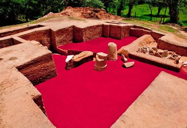
Elite residences stood on low clay platforms among the monuments. The Red Palace had earthen walls and floors finished with sand stained red by hematite. Basalt columns about four meters tall supported its roof, and L-shaped basalt benches may have covered steps. Bentonite, a clay mineral, and limestone blocks found in the debris may have formed parts of the walls.
Other buildings and workshop
Other structures had mud walls about 40 centimeters thick, apparently built from damp earth compacted in layers. Some buildings used bentonite blocks set in mud mortar. Their floors were made of gravel or packed earth, or paved with bentonite blocks. A sculptors’ workshop stood near the Red Palace.
Houses on the slopes
Ordinary residents lived on the plateau slopes, in houses descending to a level about 40 meters below the summit. The homes used wattle and daub, a woven frame covered with clay or mud, and had thatched roofs. Substantial retaining works supported the terraces, including a wall about seven meters high. It remains uncertain whether rulers directed this construction or whether commoners began it.
Studies of household refuse at El Bajio and in northern and central parts of San Lorenzo suggest that homes included separate buildings for activities such as sleeping and cooking, arranged around a central patio. This layout resembles household patterns found in the Maya highlands.