Olbia: Greek and Roman Archaeological Site at Hyères


Site at a Glance
- Rating
- 4.3
- Popularity
- Low
- Country
- France
- Primary era
- Classical
- External website
- Open
- Eras represented
- Classical, Medieval
- Civilizations
- Ancient Greek, County of Provence, Roman
- Site type
- City
On this page21 sections
History
Olbia is an archaeological site in Hyères, France, founded by the Greeks of Massalia, the ancient city of Marseille, around 325 BC. Planned as a fortified maritime colony, it protected and serviced merchant shipping between Italy and Spain while forming part of Massalia’s wider network of coastal settlements.
Greek foundation and colonial life
Olbia was established on the Mediterranean coast at Almanarre, near the sheltered waters of the Giens peninsula. Its position gave the settlement access to fertile land, productive shorelines, and a protected maritime environment. Soldier-colonists lived there while also fishing and farming, and the population may have reached several hundred people, possibly as many as about 1,000.
The town combined military control with colonization. Its regular plan and defensive enclosure helped secure this section of the coast, while its harbor supported the movement of commercial vessels. The settlement’s name and identity remained uncertain until 1909, when a Latin inscription dedicated to the Genius of the fortified district of the Olbians identified the site as Olbia rather than Pomponiana.
Roman transformation and commercial decline
Julius Caesar’s capture of Massalia in 49 BC began the Romanization of the region, meaning its gradual incorporation into Roman political, administrative, economic, and cultural systems. Olbia was probably detached from Massalia during this process. Under Roman rule, the settlement was redeveloped, its harbor was constructed or enlarged, and new residential, commercial, bathing, and religious functions were added.
Olbia’s commercial position weakened during the Roman period. Some western and northeastern districts were abandoned, and warehouses fell out of use. This contraction may have been connected with competition from Telo Martius, ancient Toulon, and Pomponiana, a nearby port or settlement in the same coastal network. By the second half of the second century AD, Olbia no longer stood among the principal maritime stages between Marseille and Fréjus.
Late antiquity and abandonment
During the fifth century, habitation became concentrated in the southeastern quarter. Other parts of the former town were reorganized into open areas, gardens, wasteland, and craft-working spaces. Iron working and forging formed part of this later occupation, showing that activity continued even as the earlier urban arrangement changed.
Olbia remained inhabited after the end of the Roman Empire but was gradually abandoned during the early seventh century. The decline has been associated with the silting and submergence of the harbor, increasing insecurity along the coast, and wider political and demographic changes in the post-Roman period. The population subsequently moved toward higher ground.
Medieval monastery and archaeological investigation
A religious establishment was later founded over the abandoned settlement. A priory appeared between the eleventh and twelfth centuries, followed by the Cistercian Abbey of Saint Peter of Almanarre, built around 1220–1221. Cistercian abbeys were monasteries whose communities followed a regulated life centered on prayer, communal discipline, and agricultural activity. The abbey remained in use until the later Middle Ages.
Archaeological remains were known by the nineteenth century. Initial surveys and soundings took place during the Second French Empire, the regime ruled by Napoleon III from 1852 to 1870. Jacques Coupry directed systematic excavations from 1947 to 1951 and from 1956 to 1971, establishing the extent, limits, and general urban plan of the ancient town.
Michel Bats continued the work from 1982 to 1989 and again from 2002 to 2008. His investigations included residential insula VI, an urban block bounded by streets, traced from its medieval levels down to the early Hellenistic foundations. Excavations along the coast from 2010 to 2013 uncovered a Roman bath complex and clarified the line of the Greek fortifications.
Research has also examined the medieval cemetery and the sanctuaries. Muriel Vecchione directed cemetery excavations in 1988, followed by work led by Michel Pasqualini and Bertrand Mafart from 1989 to 1992. Since 2019, Clément Sarrazanas has directed investigations in the Western Sanctuary and the Aphrodision within a research program led by Réjane Roure. French historic-monument protection includes the ramparts, registered in 1926, and classifications made in 1947 and 1951 for the Saint-Pierre-d’Almanarre area and the Greek rampart.
In 2025, preventive excavation, archaeological work carried out before ground-disturbing activity, examined an 800-square-metre plot outside the ancient enclosure. The work uncovered 24 cremation graves, a probably Roman wall built with reused materials, and evidence for craft production beyond the fortified town. These discoveries extended knowledge of activity around the settlement’s outer limits.
Remains
Planned town and defenses
Urban layout
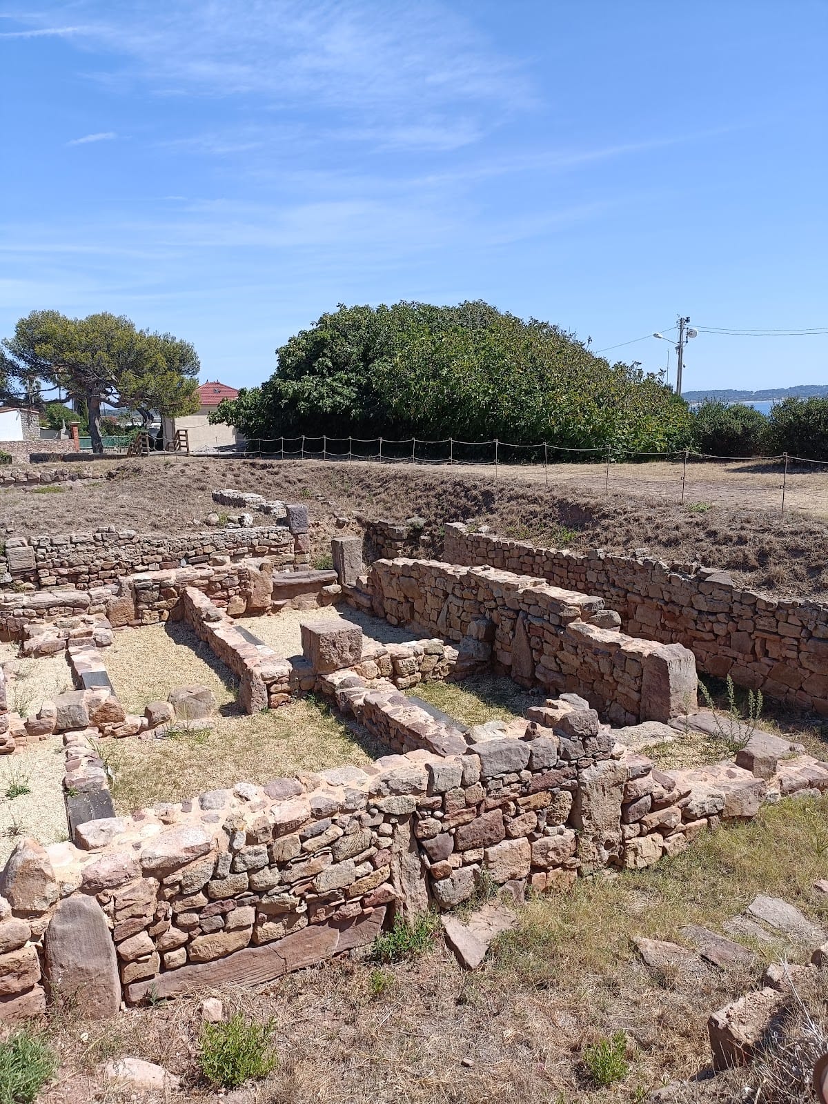
The ancient town occupied a regular square measuring approximately 165 metres on each side. Perpendicular east-west and north-south axes divided it into four equal quarters, a plan that reflected military organization and the intended equal distribution of land among the colonists. A main gate on the eastern side admitted wheeled traffic, aligned with the east-west axis and directed toward the port.
Rectangular residential blocks measured about 11 metres in width and 34.5 metres in length. Lanes approximately 2.2 metres wide separated them. At the colony’s foundation, each block was divided into three equal plots of roughly 120 square metres, with each plot intended for a colonist family.
Defensive wall
A substantial wall enclosed the settlement, with towers placed at the corners and along the sides. Two successive towers protected the eastern entrance and formed a defensive chicane, an offset approach that hindered direct access through the gate. The southern side facing the sea formed a continuous defensive line.
Harbor and water management
Submerged port
The port lay east of the town and is now partly submerged and partly covered by silt. Roman works enlarged or redeveloped the earlier harbor. Sea level has risen by almost one metre over two millennia, while stone blocks were removed and reused locally. The remaining harbor structures were later covered by the sea and sediment. The port is described as France’s only ancient sunken port.
Central well and drainage
A public well stood in the central square where the two principal axes met. Approximately eight metres deep, it remained in use until the third century AD. The square may also have served as a meeting place. Other excavated features include wells and drainage or sewer installations that formed part of the town’s water infrastructure.
Houses, shops, and public buildings
Residential and commercial quarters
Excavated areas contain Greek and Roman houses, shops, streets, and paved surfaces. Together with the planned blocks and lanes, these remains show how domestic, commercial, and civic activity occupied the enclosed town over several centuries.
Roman baths
A large Roman bath complex was built outside the southern part of the Greek enclosure, between the present departmental road and the beach. Smaller Roman baths occupied the northeastern quarter within the walls. The coastal bath remains and part of the Roman port are now submerged.
Sanctuaries and religious remains
Western Sanctuary
The Western Sanctuary stood at the western end of the main east-west axis, opposite the entrance, and was probably dedicated to Artemis. Its position at the end of the principal axis formed part of the original organization of the Greek settlement. Investigations in this area continue as part of the modern research program.
Aphrodision
The sanctuary of Aphrodite, also called the Aphrodision, stood against the northern rampart in the northeastern quarter, near the Roman baths. A hoard of approximately 100 coins dating to the third century BC was found there. The coins linked Olbia to Massalia, although the hoard later disappeared and subsequently reappeared.
Inscriptions and other finds also attest the presence of an anonymous Hero, Mother Goddesses, and additional divinities. A sculpted phallus found in reused form probably decorated the city gate. Five limestone roof-tile fragments from La Couronne were found outside stratigraphic and contextual association with the settlement.
Medieval abbey and cemetery
Abbey church and cloister
The Abbey of Saint Peter of Almanarre was built over the abandoned ancient settlement in the northeastern sector. Its church has two unequal naves, the result of enlarging an earlier structure. Part of the cloister wall also survives, preserving a visible element of the abbey’s monastic layout.
Cemetery and outer activity
The medieval cemetery was excavated in campaigns between 1988 and 1992. Outside the ancient enclosure, the 2025 excavation exposed 24 cremation burials, a probably Roman wall incorporating earlier reused materials, a press stone, and fragments of tile-concrete flooring. These features indicate craft activity in the area beyond the fortified town.
Conservation work has stabilized ancient walls, protected coastal remains from erosion, secured paths, improved the visibility of the ruins, and expanded access arrangements for people with reduced mobility.