Nicopolis ad Istrum: A Roman and Early Byzantine City in Bulgaria
Site at a Glance
- Popularity
- High
- Country
- Bulgaria
- Primary era
- Classical
- Eras represented
- Classical, Medieval
- Civilizations
- Byzantine, Roman
- Site type
- City
On this page22 sections
History
Nicopolis ad Istrum was a Roman and Early Byzantine city near Nikyup in northern Bulgaria, founded by Emperor Trajan around AD 102. Its establishment commemorated Roman victories in the Dacian Wars, including campaigns against the Roxolani, allies of the Dacians. Trajan’s Column, a monument carved with scenes from the emperor’s campaigns, depicts the wars associated with the city’s foundation.
Foundation and civic growth
The city was initially called Ulpia Nicopolis, taking Ulpia from Trajan’s family name. Its name appears in several forms: the second-century geographer Ptolemy used Nicopolis ad Haemum before AD 130, while inscriptions from AD 136 give Ulpia Nicopolis ad Istrum. Nicopolis ad Istrum became the familiar form, and Nicopolis ad Iatrum is another recorded variant. Ister was an ancient name for the Danube, although the city stood about 30 km south of that river, near the Yantra.
Nicopolis first belonged to the Roman province of Thrace and later to Moesia Inferior, after the provincial boundary moved south of the Haemus Mountains, now called the Balkan Mountains. The city prospered under Trajan, Hadrian, Antoninus Pius, and the Severan dynasty, the imperial family that included Septimius Severus and Caracalla. Its monumental growth is particularly associated with Hadrian and Antoninus Pius. The earliest inscriptions identified at the site date to AD 136.
Nicopolis became a regional center in a district of farms, livestock raising, and craft production. Its surrounding territory included prosperous villages, country estates, large estates worked by enslaved people, and trading centers. Roads linked the city with Odessos and Marcianopolis, and onward toward Melta and possibly Montana. Another route connected Novae across the Haemus with Kabile, Hadrianopolis, and Byzantium. These roads carried regional trade, military traffic, messages, and supplies.
The city had civic magistrates, a council, a popular assembly, and a council of elders. Greek was its official language. Inscriptions reflect a population that included people of Thracian and Greek origins, as well as Roman and Thracian veterans; Roman names were common. Residents also belonged to civic divisions named the Apollonias, Athenias, Capitoline, and Artemisia tribes. Inscriptions mention tradespeople such as stonecutters, carpenters, shoemakers, builders, and fullers, alongside a veterinarian and people holding civic and religious offices. Ceramic workshops in the wider territory supplied local demand and made goods for export.
Priestly groups maintained the imperial cult and worship of several deities, including the Thracian Horseman, a local god often depicted riding a horse, as well as Zeus, Hera, Athena, Heracles, Asclepius, Mithras, and Cybele. Public entertainments included gladiatorial contests and hunts involving wild animals.
Conflict and imperial change
In AD 170–171, the Costoboci sacked Nicopolis. Defensive walls were built soon afterward, and many buildings remained beyond the protected area. In AD 193, Septimius Severus, then a claimant to the imperial throne, gave the city 700,000 denarii, a Roman silver coin. A letter issued in AD 198 by Septimius Severus and Caracalla thanked the city’s leaders and inhabitants for holding a festival celebrating victory over the Parthians and for making a substantial gift. The letter may have been intended to win the city’s support and secure further privileges.
Caracalla visited in AD 211–212. Afterward, the title Ulpia disappeared from public inscriptions, apparently because the emperor was displeased with the city. He closed its mint, and Nicopolis lost its standing as a tribute-paying community with local self-government, bringing economic decline. After Caracalla’s death, the city appears to have recovered civic status and reopened its mint, although it did not regain its full earlier name.
In AD 250, Emperor Decius defeated Goths led by Cniva near Nicopolis. The following year, the Roman army lost the Battle of Abrittus, where Decius was killed. At least the northern wing of the civic square was damaged during the third century. From AD 306, under Emperor Constantine, two replacement buildings were erected there. They may have served as storehouses for supplies destined for the Danube army.
Late Roman and medieval settlement
In AD 347–348, Ulfilas, a Gothic Christian bishop, missionary, and translator, received permission from Emperor Constantius II to settle with a group of converts in Moesia, near Nicopolis. There he developed the Gothic alphabet and oversaw scholars translating the Bible from Greek into Gothic.
The Huns under Attila destroyed Nicopolis in AD 447, although the city may already have been abandoned before the early fifth century. Around the middle of that century, a much smaller fortified settlement was established within roughly one-quarter of the former city. Nicopolis later served as an Early Byzantine episcopal center. Two bishops are known by name: Marcellus, in AD 451, and Amantius, in AD 518.
Avars and Slavs destroyed the settlement in the late seventh century, during the wars between the Avars and the Byzantine Empire. A small Bulgarian settlement subsequently occupied the ruins from the ninth to the fourteenth century.
Rediscovery and investigation
In 1871, Austrian archaeologist Felix Kanitz found the base of a bronze statue dedicated to Julia Domna, wife of Septimius Severus. Its Greek inscription says that Nicopolis’s council and people erected the statue. The discovery helped identify the ancient city and establish its location. Excavations began in 1900, first under French archaeologist J. Seure and Czech archaeologist Václav Dobruský. Andrew Poulter’s team carried out further work from 1996, and investigations resumed in 2007. About one-third of the ancient city has been excavated. The site joined UNESCO’s World Heritage Tentative List in 1984 and is designated a national historic-archaeological reserve.
Remains
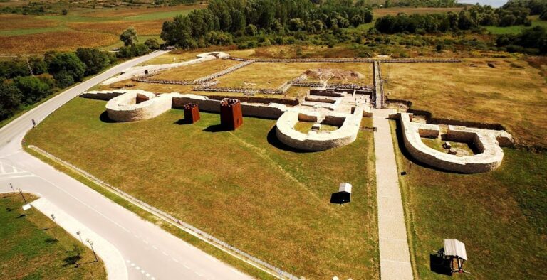
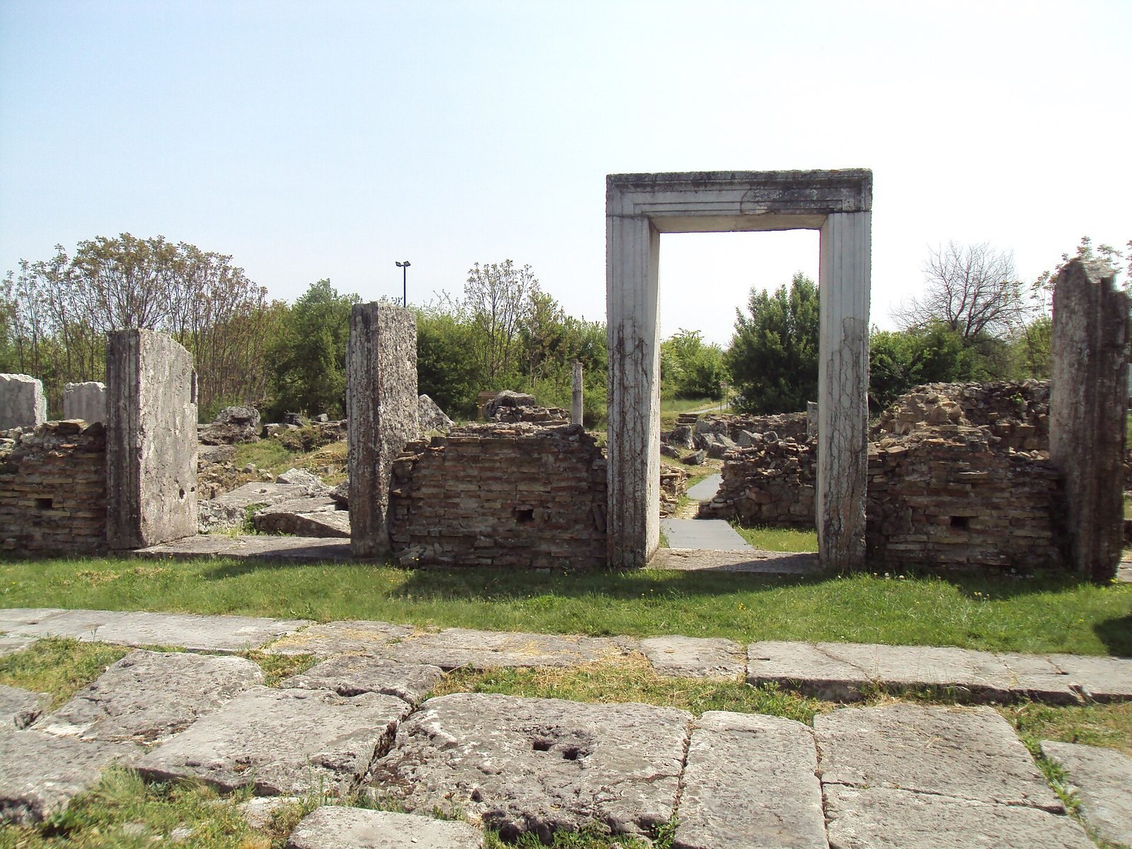
The ruins occupy a terrace on the left bank of the Rositsa River, about 18 km north of Veliko Tarnovo and 3 km southeast of Nikyup. The ancient city covered 21.55 hectares and had a larger northern fortified area and a smaller one to the southeast. Its regular street grid, stone paving, civic complex, and successive defenses show how the settlement was arranged and built.
Street plan and defenses
Streets and drainage
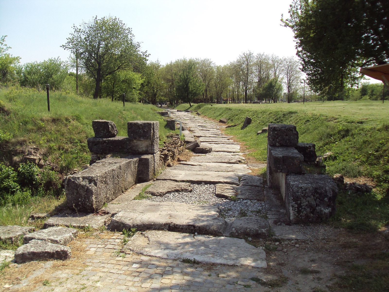
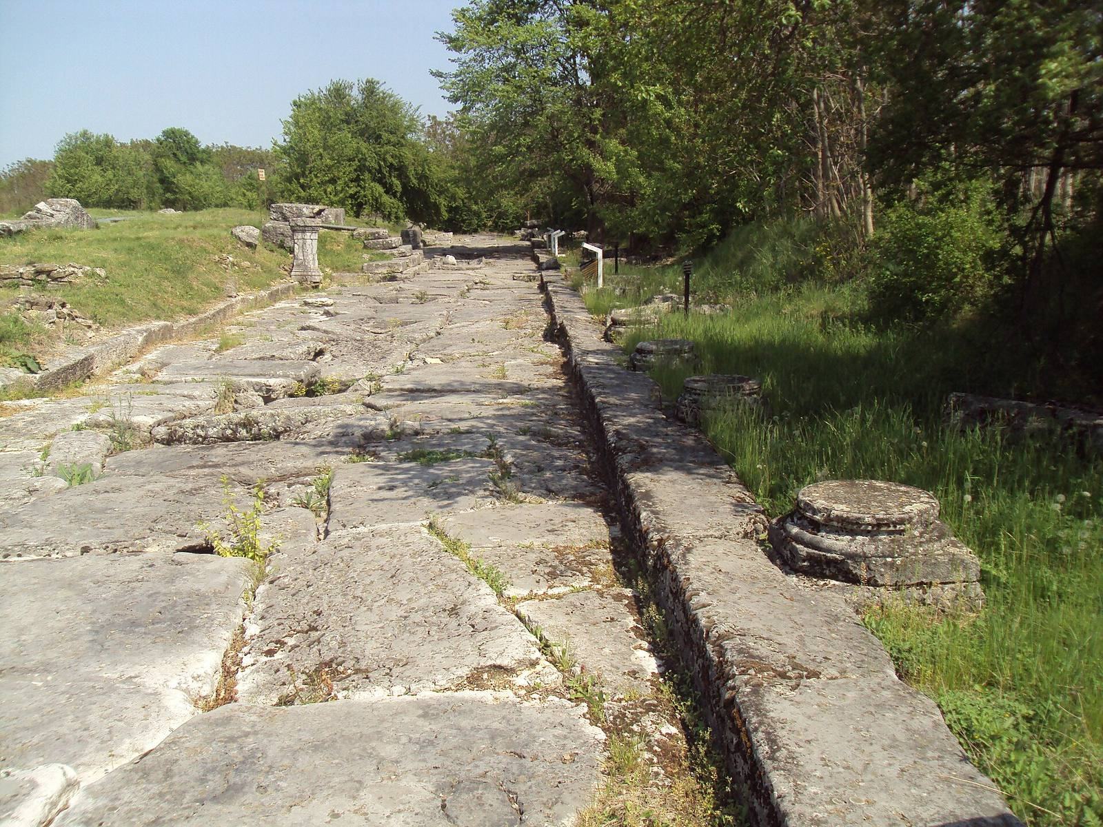
The main east–west street crossed the principal north–south street, forming the center of an orderly grid. Large stone blocks paved the streets, which also had sidewalks. A sewer ran beneath the main street, with inspection shafts set into the paving.
Walls and gates
Successive defensive walls enclosed the city, with four gates. The western gate was the principal entrance. Built from large squared stone blocks, it had an outer wooden door with two leaves and an inner gate that could be lowered into place. In the later, smaller fortified area, the old southern wall became the northern boundary. Towers were built over abandoned structures, and carved decorative blocks from earlier buildings were reused. The wall, about 10 m high, was finished with mortar scored to resemble large stone blocks. The earlier southern gate was substantially altered because it stood in a hollow below the higher ground around it.
Civic center
The public square
The civic and commercial square, or agora, had connected eastern and western sections and stood above the adjoining streets. Its eastern section was open to the sky, with limestone bases for bronze statues and an Ionic colonnade. Shops stood behind the colonnade on the south and east sides. The western section was enclosed and also had remains of an Ionic colonnade. An equestrian statue of Trajan and other marble statues stood within the complex. Its architectural decoration included elaborately carved Ionic friezes and architraves, as well as heart-shaped columns and a relief-decorated triangular pediment.
Council house
A building in the northwestern part of the square is thought to have been the council house, where the city’s governing council met.
Performance venue
The rectangular small performance venue in the southwestern part of the complex could hold up to 400 people. Its seats were arranged in sections radiating from the center. A stone barrier separated the audience from the orchestra and stage, while 11 shops occupied the space beneath the seating.
Public buildings and services
Civic and religious buildings
Public structures included a large hall with three interior aisles, a separate two-aisled room later converted into a hall of the same type, and a temple dedicated to Cybele. The large public bath stood near the north gate, and a public latrine faced a street. A building about 100 m north of the agora is thought to have been an athletic training ground. Houses, shops, and other buildings occupied the remaining urban space.
Heated public building
A heated public building known as the thermoperipatos (a heated public building with a walking hall) occupied an entire block beside the agora. Built over an earlier structure in AD 184–185 under Emperor Commodus, it resembled a large hall with three aisles. Shops surrounded an enclosed central area used for walking, business meetings, and conversation. The building was probably associated with trade. It fell into ruin in the fourth century, and another structure was later built over it.
Water supply and heating
Three aqueducts, numerous wells, and several surviving fountains supplied the city. The western aqueduct ran about 25 km and crossed the Rositsa valley on a bridge nearly 3 km long and about 20 m high. It drew water from karst springs at Musina Cave, near Musina, where a second-century collection reservoir still gathers water. Part of the channel survives near Dichin. A reservoir lies about 200 m west of the city, and a large water-distribution building stood farther west. The aqueduct could supply 16,000 liters of water a day.
A heating system was identified behind a building described as the senate, near the agora. Clay pipes with openings at their lower ends supported stone slabs that formed the floor, allowing hot air to circulate beneath it. The paved streets also included an open-air walkway heated during winter; exotic plants may have grown alongside it.
Workshops, cemetery, and finds
Production and riverfront
Pottery workshops occupied the northern part of the city. A harbor stood south of the settlement on the Rositsa River. A large building uncovered in 2015 may have been the residence of a market official or a Roman civic magistrate responsible for market affairs, though its function remains uncertain.
Cemetery
The cemetery near the north gate reflects the range of social groups in the city. The dead were cremated or buried in flat graves and stone coffins. Wealthy families had richly decorated tombs with colonnades, recessed spaces, triangular pediments, and statues. Some graves were covered by mounds.
Inscriptions, sculptures, and coins
A small square at the southwestern corner of the civic complex yielded an altar to Tyche, the Greek goddess associated with the fortune of cities. Found in 2018, it bears an inscription adapting a short poem by the Athenian orator Demosthenes. A statue of Asclepius, the Greek god of healing, was recovered after looters removed it and attempted to sell it; it is now held by the History Museum in Veliko Tarnovo.
A silver coin weighing about 30 g and bearing Trajan’s image was found during archaeological work resumed in 2007. It dates to the late second century. The city also produced bronze coins showing deities, fortifications, and public and religious buildings, with Greek inscriptions. The 14 m obelisk of Quintus Julius, an aristocrat of Nicopolis, still stands in the countryside near Lesicheri, about 12 km west of the city.
Animal remains
Analysis of bones from the 1986–1989 Bulgarian-British expedition identified 55 bird species. The remains included bearded vultures, great bustards, little bustards, nutcrackers, alpine choughs, Colchian pheasants, and common shelducks. Domestic Indian peafowl were also identified, marking the first record of the species in Bulgaria.