Guiengola: A Fortified Zapotec Urban Settlement in Mexico
Site at a Glance
- Rating
- 4.5
- Popularity
- Very Low
- Country
- Mexico
- Primary era
- Medieval
- Eras represented
- Medieval, Early Modern
- Civilizations
- Zapotec
- Site type
- City
On this page18 sections
History
Guiengola is a Zapotec archaeological settlement in Carr. Internacional, Oaxaca, Mexico, associated with the Late Postclassic period, approximately 1350 to 1521, although its chronology may begin earlier. Built and developed as Zapotec power expanded toward the Isthmus of Tehuantepec, it was a planned urban and regional political center with civic, residential, ceremonial, administrative, and defensive functions. The settlement occupied elevated ground above the Tehuantepec River system and the surrounding lowlands, helping control a corridor between the highlands of Oaxaca and coastal and Gulf regions.
Urban growth and regional power
Guiengola formed part of a broader movement of Zapotec communities from the Central Valleys of Oaxaca toward the Isthmus. The city’s position provided access to commercial routes and varied resources, while its elevated terrain offered a strong defensive location. Its population was socially differentiated, with neighborhoods and separate spaces for elites and the wider population. Roads, terraces, residential clusters, public buildings, and defensive works together indicate a substantial urban settlement rather than an isolated military post.
Its walls, controlled entrances, observation points, and position across hills and slopes indicate a role in watching and defending the region against hostile groups. Guiengola probably also served as an administrative center for the Zapotec Isthmus. The settlement’s scale and organization reflect the political expansion of Zapotec communities during the final major pre-Hispanic period in much of Mesoamerica, the cultural region extending across central and southern Mexico and parts of Central America.
Conflict with the Mexica
Guiengola became associated with conflict between the Zapotec and Mexica states in the decades before Spanish colonization. The Mexica were the imperial polity centered at Tenochtitlan. Their expansion toward the Isthmus sought tribute, political control, and access to routes leading toward Soconusco and Guatemala. Sixteenth-century traditions describe a Mexica siege of Guiengola, although the interpretation of these events remains debated.
According to the historical tradition, Zapotec ruler Cosijoeza and his Mixtec allies resisted attacks commanded by Ahuizotl, the Mexica ruler from 1486 to 1502. Cosijoeza successfully defended the city, and hostilities ended through his marriage to Coyolicatzin, a daughter of Ahuizotl. Their son, Cosijopí Sicasibí, became the last Zapotec ruler. After the Spanish conquest, he was baptized as Juan Cortés and later prosecuted by the Inquisition, the institution that investigated and prosecuted alleged religious offenses in Spanish territories, on charges of idolatry.
Abandonment and archaeological investigation
Guiengola was abandoned by its Zapotec inhabitants after the Spanish conquest and was not subsequently reoccupied. Its ruins remained in place. Travelers, chroniclers, explorers, and archaeologists began recording the settlement from the nineteenth century onward. Investigators included Gustavus Ferdinand von Tempski in 1858, Aureliano Estrada and Eduard Seler in the late nineteenth century, and Alberto Escalona Ramos, José S. Noriega, Miguel Covarrubias, James Forster, Matthew Wallrath, David Peterson, Thomas MacDougall, and Martín Cendrero Cusminski during the twentieth century.
Mexican government investigations included work by Lorenzo Gamio, Carlos Margarín, and Vicente Doria in 1953, followed by research by Enrique Fernández Dávila in 2006 and 2021. Later studies by Pedro Guillermo Ramón Celis included research published in 2018 and subsequent archaeological mapping. Documentation, registration, stabilization, limited excavation, pedestrian survey, and airborne LiDAR mapping, a method that creates detailed topographic models from light pulses, revealed the settlement’s full scale. These investigations established Guiengola as a fortified Late Postclassic city and clarified its importance for understanding Zapotec political expansion, urban organization, regional interaction, and everyday life.
Survey and LiDAR mapping cover approximately 360 hectares and identify more than one thousand architectural features. Guiengola also remains part of the cultural memory and regional identity of communities around Santo Domingo Tehuantepec. Conservation discussions have involved communal authorities, educators, artists, landholders, and other local stakeholders in considering the management of the archaeological landscape.
Remains
Guiengola extends across hilltops, slopes, terraces, and leveled platforms. Its builders adapted the natural terrain with retaining walls, modified slopes, internal roads, controlled access points, and defensive constructions. Buildings were made from locally quarried stone slabs joined with mortar and finished with stucco. Platforms, masonry walls, stairways, patios, terraces, and retaining walls were arranged to accommodate uneven ground. The mapped settlement includes a central civic-ceremonial area, elite compounds, commoner residences, neighborhood groups, tombs, caves, roads, and defensive works spread across roughly 360 hectares.
Civic and ceremonial center
The central civic-ceremonial area, or epicenter, occupies an artificially leveled surface about 150 by 200 meters between two rocky hills. An epicenter is the principal concentration of monumental, civic, ceremonial, and elite architecture within a larger settlement. The core was approached from the north through a narrow valley and contains two sunken plazas, one higher than the other, more than one hundred structures, two ballcourts, large residential complexes, and other public buildings.
East Pyramid
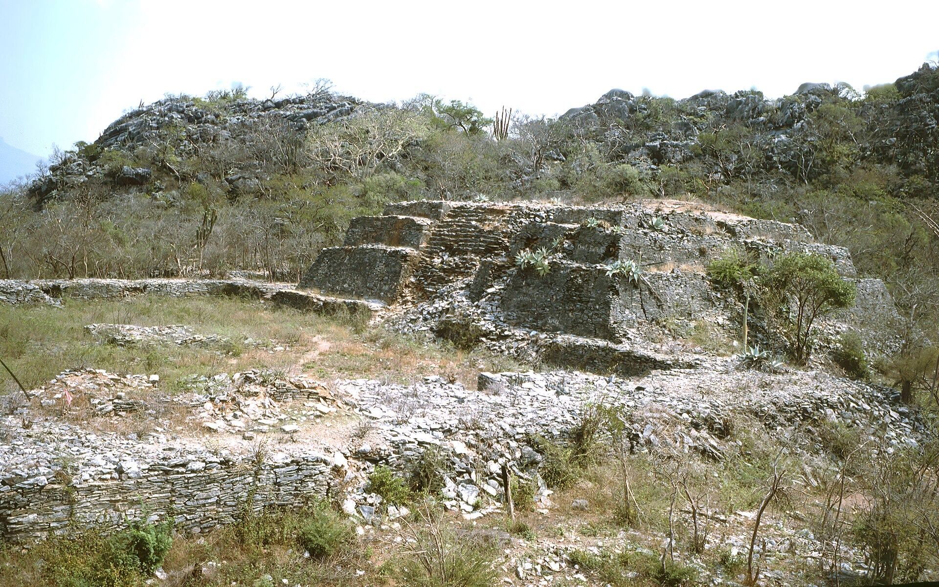
The East Pyramid was the principal structure in the central area. It measures about 30 by 40 meters and is slightly recessed, standing over an earlier pyramid. A perimeter wall roughly two meters thick and 60 centimeters high enclosed the associated plaza. The pyramid has three bodies, a broad staircase on the west, and an embedded stairway about eight meters long leading to the summit. Two narrower stairways occupy its sides, while additional stairs connect the different levels.
A possible sanctuary stood beside the pyramid’s eastern wall. Its surface was fully covered with stucco, and it faced a sunken plaza containing a round altar. The pyramids probably served as temples, while the altar may have received offerings and the adjoining plaza accommodated gatherings and ceremonies.
West Pyramid
The West Pyramid also has three bodies and an embedded western staircase about eight meters long. At its upper level are the remains of an adobe building, with additional rooms behind it, each measuring nearly 13 meters. Together with the East Pyramid, it formed part of the monumental architecture surrounding the central plazas.
Ballcourts and adjacent structures
The main ballcourt lies east of the principal plaza, while another is located within the mapped epicenter. Ballcourt No. 1 stands beside the North Plaza and follows the Mesoamerican I-shaped plan, with a long central playing area bordered by parallel structures and terminal spaces. The other described court is rectangular, enclosed by a wall, and approached from the north by two small steps. Several nearby structures are circular. Some researchers have tentatively interpreted them as astronomical observatories because their entrances offered views toward important stars that may have helped measure time.
Palaces and elite compounds
Principal Palace
The Palace, or principal residential complex, lies about 200 meters southeast of the ceremonial center on the eastern side of the site. It covers approximately 11,000 square meters and includes 64 rooms and other irregularly arranged structures built on sloping terraces. Residential buildings, circular columns, interconnected patios, and numerous stairways respond to changes in elevation. The described access is from the south.
Within the complex, a small irregular courtyard known as Patio 11 had restricted access through a narrow southern staircase and is interpreted as the royal residential area. The palace also contains a temple-like building with three consecutive spaces and doorways supported by two round columns. A circular lookout was built on natural rock within the complex, offering views across much of the Isthmus. The palace is probably associated with Cosijoeza, although that attribution remains interpretive.
South Palace Complex
The South Palace Complex is one of the largest architectural groups identified at Guiengola. It includes interconnected plazas, raised platforms, multi-room compounds, broad staircases, terraced retaining walls, and enclosed patios arranged along a defensible ridge. Its scale and organization indicate a probable role in elite residence and governance. Internal roads and passageways connected the complex with other sectors of the settlement.
North Elite Residences
The North Plaza is associated with the North Elite Residences. Their access was controlled through stairways, terraces, internal passageways, substantial masonry walls, and carefully leveled platforms. The arrangement forms part of the settlement’s wider pattern of differentiated residential and public spaces.
Residential neighborhoods and circulation
Beyond the epicenter and the major elite compounds, numerous residential structures occupy terraces and slopes. They include small patio groups, domestic platforms, and associated retaining walls. Differences in size, construction quality, and arrangement indicate social differentiation, while clusters of residences may represent neighborhood units or barrios, or residential districts.
Internal roads and paths linked plazas, residential sectors, elevated complexes, and other architectural areas across uneven terrain. Defensive walls and controlled access points occurred in several sectors rather than forming a single continuous perimeter. This distributed arrangement combined movement, neighborhood organization, and defense across the hills and terraces.
Tombs, caves, and carved monuments
Principal tombs
Two principal tombs had been looted by the nineteenth century. One lies beside the perimeter wall of the East Pyramid courtyard. Its western entrance leads to a funerary chamber approximately nine meters long and two meters wide, with two small side chambers. The second lies beneath a small temple in the palace area and contains three parallel chambers. Colonial information identifies the large chamber as a sanctuary and indicates that the side chambers were reused.
Cruciform tombs
Several cruciform tombs occupy the northern end of the small valley, at the northwestern corner of the sunken plaza. Their concentration has led to the interpretation of this area as a cemetery. These burial structures add a funerary dimension to the civic, residential, and ceremonial organization of the settlement.
Caves and Snake Plaza
Caves occur on nearly every side of the hills, with some entrances blocked. One cave at the base of large rocks near the ceremonial area contains stalactites and stalagmites and may have served a ceremonial function. Legends are associated with the caves, and surviving traces indicate that rock paintings were almost completely destroyed.
Snake Plaza takes its name from a carved stone monument bearing a serpent motif. Early descriptions of Guiengola recorded the monument, which is now held at the National Museum of Anthropology in Mexico City.