Fort Stanwix: A British Fort Guarding the Oneida Carry
Site at a Glance
- Country
- United States
- Primary era
- Early Modern
- Eras represented
- Early Modern
- Civilizations
- British
- Site type
- Military
- Remains
- Fort
On this page9 sections
History
Construction and treaty negotiations
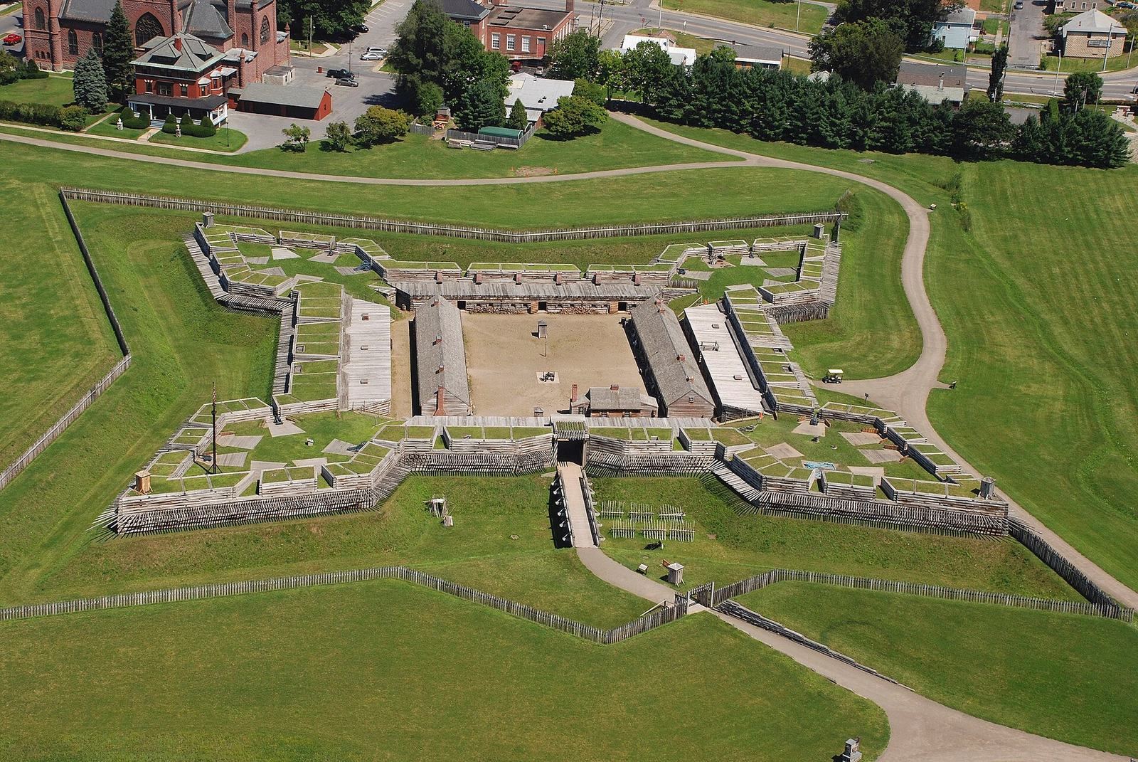
Fort Stanwix is a reconstructed British colonial fort at Rome in the United States, originally built as a bastion fort, a design with angled projections that helped defend its walls. Construction began on August 26, 1758, during the French and Indian War, the North American conflict between Britain, France, and their Indigenous allies that formed part of the wider Seven Years’ War. British General John Stanwix directed the work, which was completed by 1762. The fort guarded the Oneida Carry, a portage of nearly five kilometers where people carried boats or cargo between waterways. The route linked travel toward the Hudson River and Atlantic coast with a northwestern passage across Oneida Lake to Oswego on Lake Ontario.
In 1768, when the fort was dilapidated and inactive, British colonial administrator William Johnson arranged treaty negotiations there with the Iroquois, a confederacy of Indigenous nations in northeastern North America. The talks sought to revise the boundary set by the 1763 Royal Proclamation, a British decree regulating colonial settlement west of the Appalachian Mountains. British officials hoped a new boundary would reduce costly frontier violence, while Indigenous peoples sought to restrain colonial expansion. Signed on November 5, the agreement moved the boundary farther west and effectively ceded Kentucky to the British. The Shawnee, Delaware, and Cherokee, who used those lands, were excluded from the negotiations. Rather than securing peace, the agreement helped prepare the way for further conflict. The fort was abandoned later that year.
Fort Stanwix in the American Revolution
American troops under Colonel Elias Dayton reoccupied the fort on July 12, 1776, and began rebuilding it. They renamed it Fort Schuyler in honor of Major General Philip Schuyler, although Fort Stanwix remained the name in common use. Colonel Peter Gansevoort took command on May 3, 1777. On August 3, a British force under Brigadier General Barry St. Leger began a siege. The force included the King’s 8th Regiment of Foot, Loyalists, and Native American allies. St. Leger was part of a British campaign intended to divide the colonies during the American Revolutionary War. Gansevoort refused the demand to surrender, and the siege continued for 21 days.
A few miles southeast, an American relief column led by General Nicholas Herkimer was ambushed by Loyalists and their Indigenous allies at the Battle of Oriskany. While many of the besiegers were occupied there, defenders from the fort attacked their camp and destroyed or took its supplies. The British force, weakened and demoralized, withdrew after reports circulated that another relief column led by General Benedict Arnold was approaching. It retreated through Canada and joined General John Burgoyne’s campaign at Fort Ticonderoga. The British failure to capture Fort Stanwix or advance down the Mohawk Valley contributed to Burgoyne’s defeat at Saratoga, a major setback for the British campaign.
Local tradition identifies the flag raised over the fort on August 3, 1777, as the first United States flag flown in battle. It was more likely a thirteen-stripe design, perhaps an early New York flag or the Continental Union Flag, which retained the British Union flag in its upper corner.
Destruction, treaties, and later use
Fire destroyed the original fort on May 13, 1781. It was not rebuilt, and its garrison moved to Fort Herkimer. In 1784, the ruins hosted another treaty between the United States and the Iroquois, also called the Six Nations. The agreement recognized the Iroquois as U.S. allies and broadly guaranteed their traditional lands. It also dissolved their coalition and ended their guerrilla war against white settlers southeast of the Appalachians. Within a few years, New York State no longer recognized the treaty’s claims concerning land and independence.
During the War of 1812, a blockhouse was built on the fort’s parade ground. The Erie Canal, which opened in 1817, replaced the old waterway and portage route. Dismantling of the fortifications began in 1828, as Rome expanded across the site during the nineteenth century.
National monument and reconstruction
President Franklin D. Roosevelt signed the legislation establishing Fort Stanwix National Monument on August 21, 1935, when homes and businesses still occupied the future monument land. The former fort site became a National Historic Landmark in 1962 and was added to the National Register of Historic Places in 1966. During the 1960s, Rome’s leaders pursued a reconstruction as part of downtown renewal and sought to attract tourism after the city’s largest employer, a U.S. Air Force base, closed in 1964. Senator Robert F. Kennedy’s political pressure helped persuade the initially reluctant National Park Service to proceed with a reconstruction of the Revolutionary War-era fort.
The Park Service completed a master plan in 1967, followed by a three-year archaeological investigation that began in 1970. Reconstruction started in 1974, was partly complete for the 1976 United States Bicentennial, and was finished in 1978. Some construction used historical methods. From 1976 until the mid-1990s, interpretation focused on the Revolutionary War and life just after the siege, in 1777–78. It later expanded to include the French and Indian War and the fort’s role in treaty negotiations with Native Americans.
Remains
Reconstructed fort
The reconstructed fort occupies the original site within the 16-acre national monument. Its reinforced-concrete structure is clad in earth and timber and surrounds three freestanding buildings. The reconstruction represents the fort’s defensive design and provides the principal built feature of the site.
Trails and the Oneida Carry
Three short trails encircle the reconstructed fort. One follows part of the Oneida Carry, the portage route that connected waterways in the Mohawk Valley with routes toward Lake Ontario.
Collections and education center
The Marinus Willett Collections Management and Education Center preserves 485,000 artifacts and documents. It also presents exhibits about Fort Stanwix and the Mohawk Valley.