Fort Frontenac: A French Trading Post and Military Outpost in Kingston
Site at a Glance
- Rating
- 4.4
- Popularity
- Very Low
- Country
- Canada
- Primary era
- Modern
- Eras represented
- Early Modern, Modern
- Civilizations
- British, French
- Site type
- Military
- Remains
- Fort
On this page17 sections
History
Fort Frontenac is a French colonial fortification in Kingston, Canada, established in July 1673 at the mouth of the Cataraqui River, where the St. Lawrence River leaves Lake Ontario. Built by New France during the seventeenth century, it occupied the western Great Lakes region known as the Pays-d’en-Haut. Its position beside a sheltered bay gave France access to the Great Lakes waterways and supported a trading post, military outpost, religious mission, and base for exploration.
Foundation under Frontenac
The fort followed Governor Louis de Buade de Frontenac’s meeting with representatives of the Five Nations, the original Iroquois Confederacy, on 12 July 1673. The meeting aimed to encourage trade and peace. The new post was first called Fort Cataraqui, Cataracoui, or Kataracouy after the river, and later became Fort Frontenac in honour of the governor.
Frontenac ordered the construction and personally financed the fort and its garrison at a cost of more than 15,000 livres. René-Robert Cavelier de La Salle selected and administered the site, while the military engineer Hugues Randin prepared the plans and directed the initial work. About 400 regular soldiers of the Carignan-Salières Regiment, a French force sent to strengthen colonial defence, accompanied Frontenac to the location.
France established the fort to control the fur trade around the Great Lakes and the Canadian Shield, support expansion toward the upper Mississippi and Ohio Valley, protect Montreal, and challenge English and Dutch commercial competition. It also supplied and reinforced other French posts. Frontenac and his associates hoped to profit from the exchange of goods, and Frontenac regularly visited with canoes carrying merchandise for trade with Indigenous communities.
La Salle became the fort’s first administrator and commander. In 1675, he received ownership and administrative authority after agreeing to reimburse Frontenac, complete the stone fort, maintain a suitable garrison, attract settlers, establish French and Indigenous villages, and support Recollet missionaries. The Recollets were a reform branch of the Franciscan order. La Salle also received adjoining land, two nearby islands, and fishing rights. During his absences, François Dauphin de la Forest represented him as major.
A small Recollet community formed at the post under Father Gabriel de la Ribourde. Louis Hennepin and Luc Buisset took part in mission and construction work. By 1685, French civilians, Indigenous people, and Recollet religious personnel lived around the fort. Cleared land supported cultivation and the raising of cattle, pigs, poultry, and other domestic animals. In peaceful periods, Iroquois communities supplied the garrison with fish and game in exchange for European goods.
Expansion, exploration, and war
Fort Frontenac served as a base for French movement through the interior of North America. On 18 November 1678, La Salle departed from the post to establish a route linking New France with the Gulf of Mexico. The fort also supported communications and the movement of supplies across the Great Lakes region.
Fur-trade rivalries helped revive warfare between France and the Iroquois during the 1680s. In 1687, Governor Jacques-René de Brisay, Marquis de Denonville, detained Iroquois people during his campaign against the Seneca, including some who had previously been friendly to the French. Several prisoners were sent to France as galley slaves, further damaging relations.
The Iroquois besieged Fort Frontenac and the settlement at Cataraqui for about two months in 1688. The fort survived, but the settlement was devastated. Many inhabitants died, mostly from scurvy, while three soldiers and Madeleine de Roybon d’Allonne were taken captive. Archaeological investigations have suggested that some remains found at the site may belong to 93 defenders who died during the siege.
After the destruction of Lachine in 1689, Denonville ordered the fort partly destroyed. In 1691, Frontenac instructed Pierre Legardeur de Repentigny to abandon it and evacuate the garrison to Quebec because its remote position made defence and resupply difficult. Frontenac ordered the fort rebuilt in 1695 despite opposition from the colonial administration. About 300 troops under François-Charles de Bourlamaque and 160 inhabitants reinforced the post, which resumed its military role. A French force of about 2,000 men later assembled there for an expedition against Iroquois communities south of Lake Ontario.
François DeJordy-Moreau became commandant in 1696, followed by Louis de Laporte, Sieur de Louvigny, in 1699. Louvigny was arrested and removed after illegally trading furs in violation of the 1696 prohibition on commerce at western posts. On 4 August 1701, France and Indigenous peoples including the Iroquois signed the Great Peace of Montreal. The Huron leader Kondiaronk played an important diplomatic role in reaching the agreement.
French military and commercial centre
During the early eighteenth century, France increased the fort’s armament, barracks, and garrison. In the 1720s, its commanders strengthened the connections among Montreal, Fort Frontenac, and Fort Michilimackinac. By 1744, the post had become an important supply depot for French positions farther inland and was reinforced in anticipation of war. Nearby merchants operated warehouses and wharves by 1754, when the settlement had developed a substantial shipping trade.
Captain Pierre Pouchot arrived in July 1755 with the Béarn and Guyenne regiments and helped improve the defences. In August 1756, the Marquis de Montcalm used Fort Frontenac as a staging point for his attack on the British fortifications at Oswego.
During the Seven Years’ War, an international conflict fought from 1756 to 1763, Britain and France contested colonial territory and trade routes in North America. Britain regarded Fort Frontenac as a strategic threat because it supported French transportation and communications along the St. Lawrence and Great Lakes waterways and toward the Ohio Valley. Its destruction would also protect the British fort at Oswego and disrupt French supplies and trade.
In August 1758, a British and American force of slightly more than 3,000 men under Lieutenant-Colonel John Bradstreet attacked. The French garrison under Pierre-Jacques Payen de Noyan numbered about 110 people, including 48 enlisted soldiers, five officers, Indigenous allies, employees, women, and children. The French surrendered and were allowed to leave. Bradstreet seized the supplies and nine French naval vessels, destroyed much of the fort, and withdrew quickly to avoid a French relief force.
The capture did not completely sever French communications, since alternative routes such as the Ottawa River and Lake Huron route remained available. It nevertheless weakened French prestige and contributed to the decline of New France. After the Treaty of Paris in 1763, Cataraqui and the remains of Fort Frontenac passed to the British Crown.
British and Canadian military use
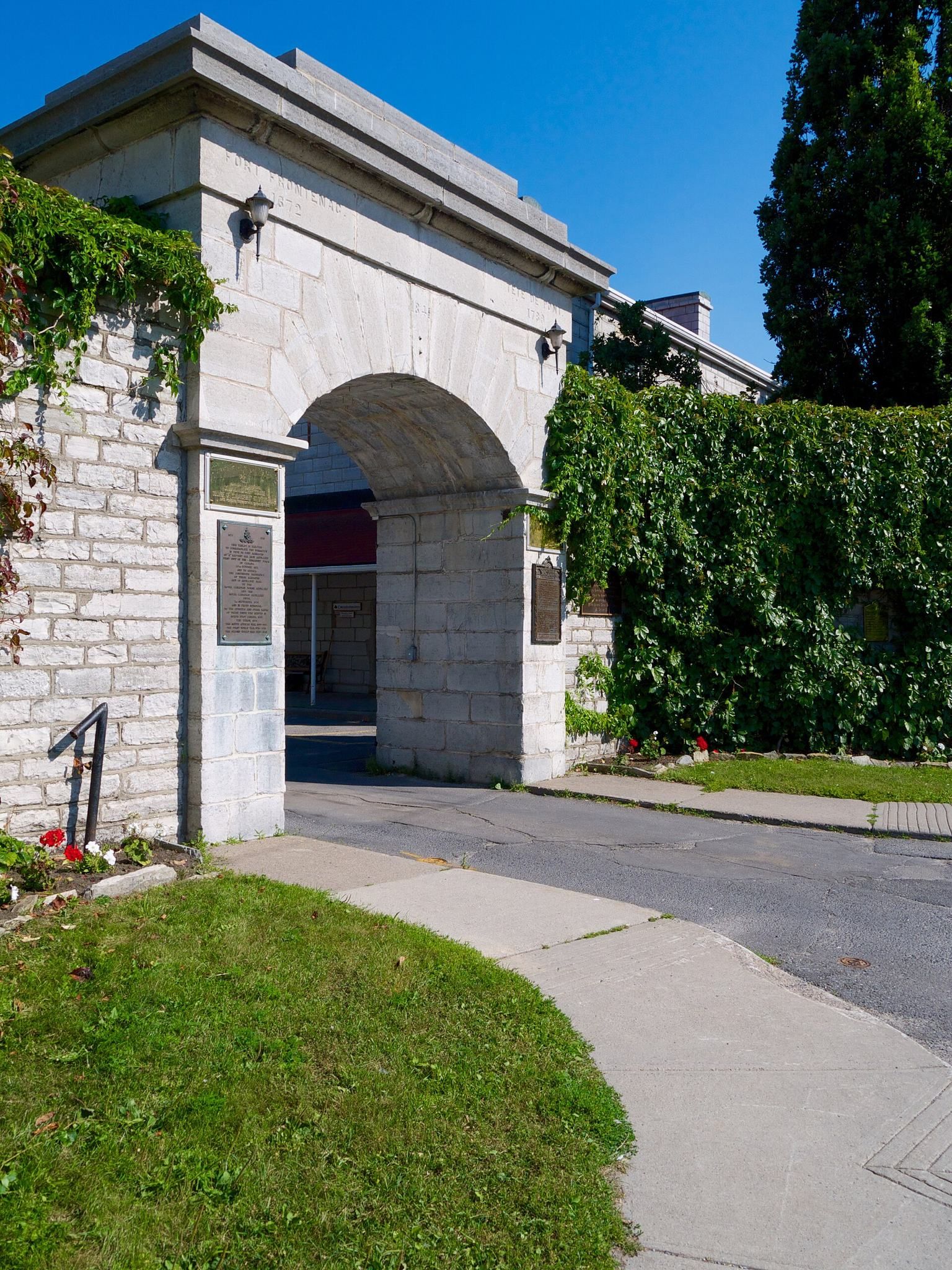
The site remained abandoned until 1783, when Britain selected the area for Loyalist settlement after the American Revolution and ordered the fort rebuilt as a military and naval base. Governor Frederick Haldimand directed Major John Ross, the commander at Oswego, to repair and reconstruct the post. A force of approximately 422 men and 25 officers completed a lime kiln, hospital, barracks, officers’ quarters, storehouses, and a bakehouse. The complex became informally known as Tête-de-Pont Barracks, or Bridgehead Barracks, in the late eighteenth century.
During the War of 1812, the fort served as an important British military centre and focused operations in the Kingston region. Many of the surviving barrack buildings were constructed between 1821 and 1824. In 1870 and 1871, responsibility passed from British imperial forces to the Canadian military. The site became a centre for Canadian garrison artillery training and served as the headquarters of the Royal Canadian Horse Artillery from 1905 to 1939.
The site resumed the name Fort Frontenac in 1939. During the Second World War, it was used as a personnel depot. The Canadian Army Staff College moved there in 1948 and is now known as the Canadian Army Command and Staff College. The National Defence College also operated at the site until 1994. Fort Frontenac remains in military use as a college and barracks complex.
Archaeology and historic recognition
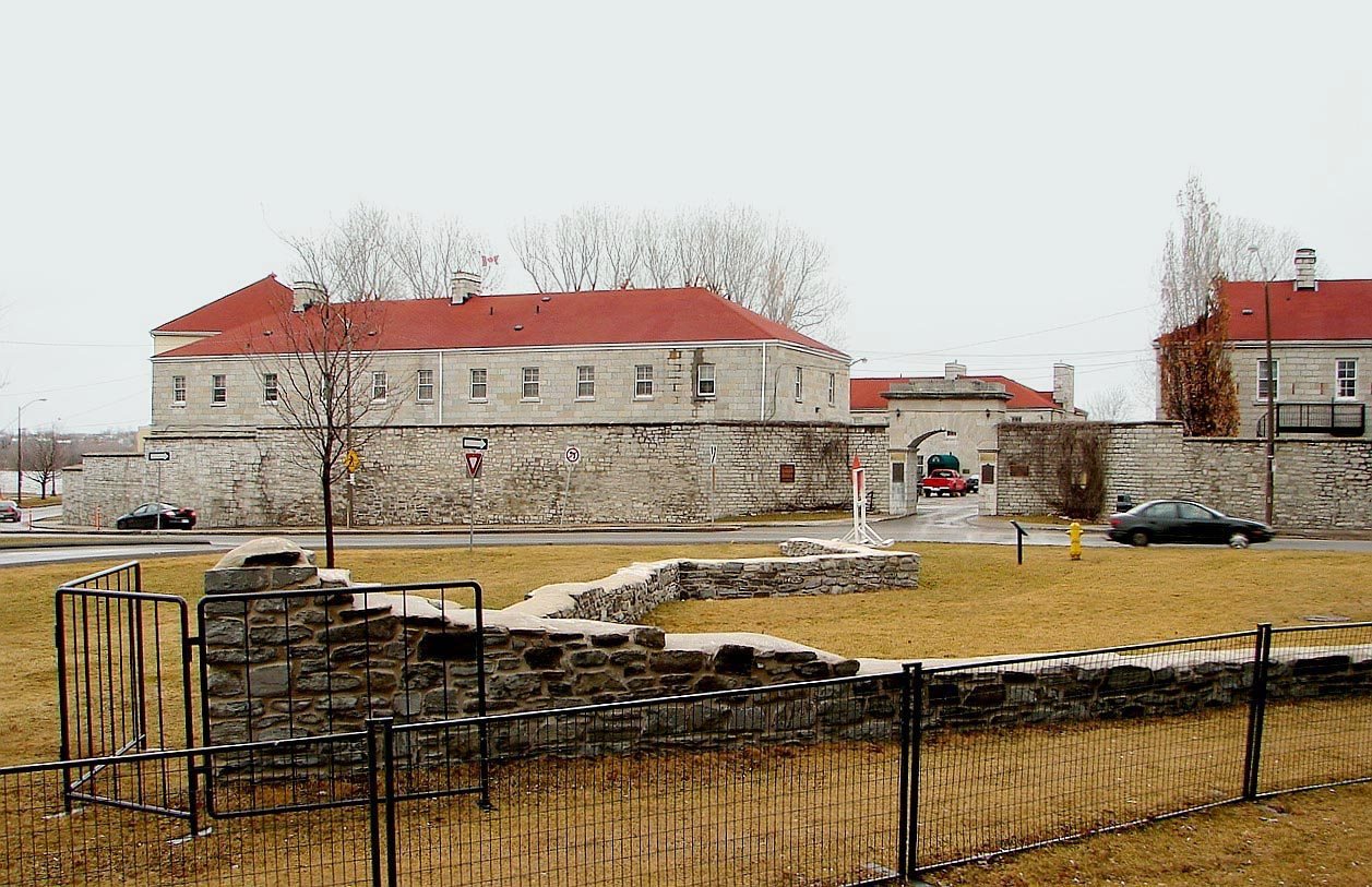
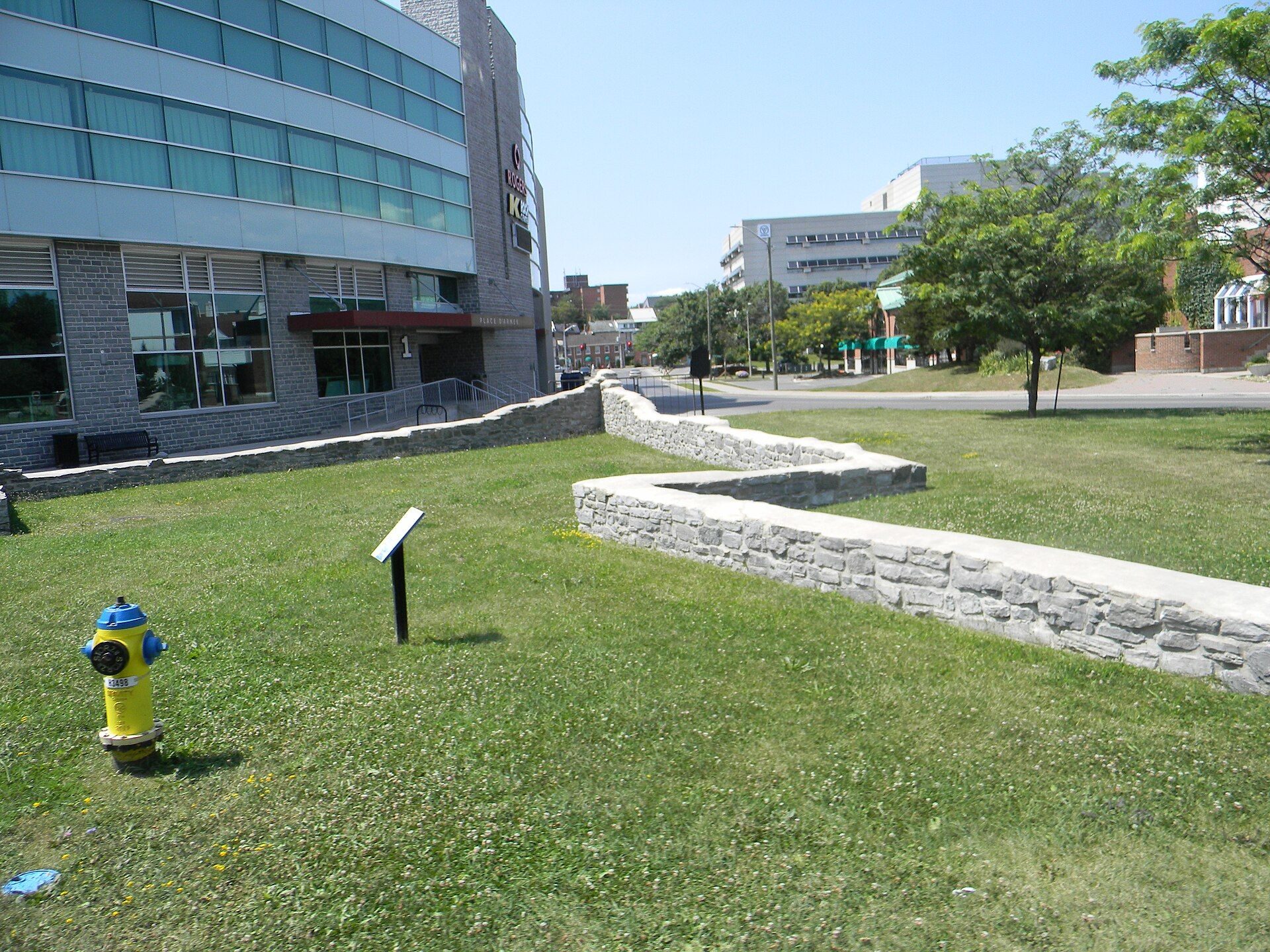
Fort Frontenac was designated a National Historic Site of Canada on 25 May 1923. Archaeological investigations began in 1982 and clarified the fort’s development, use, and relationship to historic maps and plans. In 1984, Kingston altered the intersection of Ontario and Place d’Armes Streets to permit excavation and partial reconstruction of the northwest bastion and its curtain wall.
Archaeological work continued into the twenty-first century, including the discovery of the intact east bastion in 2020. Research and excavation have helped distinguish the original French fortifications from the later British and Canadian military buildings. Restored remnants of the French stone fort remain visible within the modern complex.
Remains
Fort Frontenac occupied a peninsula beside Lake Ontario, with its isthmus cut by a ditch and its other sides bordered by the lake and a large harbour. The harbour could shelter various vessels and allowed larger lake-going boats to operate more efficiently than the canoe-only Ottawa River route. The fort developed from a compact wooden enclosure into a stone fort with four projecting bastions, surrounding settlement, military buildings, and harbour facilities.
French fortifications
Original enclosure and stone walls
The first fort was a roughly square wooden palisade built on a point of land near the sheltered bay. Each side measured about 90 feet. Construction was completed in roughly six days, with the work finished by 19 July 1673 and the enclosure palisaded by the following day.
Beginning in 1675, the wooden fort was dismantled and replaced with stone. The later fort had a perimeter of about 360 toises and four stone bastions, which were projecting fortified platforms placed at the corners to provide defensive fire along the walls and approaches. By 1676 to 1678, most of the wooden palisade had been replaced by masonry. A seventeenth-century description gives the walls a thickness of about three feet and a height of twelve feet, with one unfinished section measuring only about four feet high. Ditches around the fort were approximately fifteen feet wide.
Northwest and east bastions
The northwest bastion, also called Bastion Saint-Michel, and part of the curtain wall, the defensive wall between two bastions, were excavated and partially reconstructed during the 1980s. These works exposed portions of the original French fortifications in central Kingston and made their relationship to the later military complex clearer.
Archaeologists located intact remains of the east bastion in 2020. Deposits beside its wall contained trade beads from the fur-trade period, beaver jaws, gunflints, and fish bones. These objects connect the surviving masonry with the commercial and military activity that took place at the French post.
Buildings and settlement
Interior buildings
The fort’s interior included a roughly square log house about 100 feet long, a blacksmith’s shop, a guardhouse, officers’ quarters, a well, and a cow house. A barn stood outside the enclosure near cleared and cultivated land, where crops could be stored. During the later seventeenth century, the bastions were enlarged and additional dwellings were added.
Mission and surrounding community
A chapel and Recollet missionary residence were built between 1676 and 1678. French houses, an Iroquois village, a Recollet convent, and a Recollet church stood near the fort. The surrounding settlement also included cultivated fields, livestock facilities, and buildings associated with trade and mission activity.
Later military complex
French improvements and harbour facilities
By the 1720s, the fort’s structures were in stone, and new barracks, guns, and other military additions had been installed. Warehouses and wharves operated nearby by 1754, reflecting the post’s role in supplying interior settlements and handling lake traffic.
An inspection during the 1750s described masonry walls about three to three and a half feet thick at the base and two feet thick at the top, with an estimated height of 20 to 25 feet. The inspection also noted cannon openings in the bastions and wooden scaffolding along much of the defensive wall. The British attack of 1758 destroyed much of the French fort and its associated naval vessels.
British and Canadian buildings
The rebuilt British complex of 1783 included a lime kiln, hospital, barracks, officers’ quarters, storehouses, and a bakehouse. Many barrack buildings that survive today date from 1821 to 1824. They stand alongside the excavated and restored remnants of the earlier French fort, allowing the site’s successive military phases to be read together.
Archaeological deposits and burials
Excavations within the former enclosure have revealed numerous archaeological objects and burials. The finds include the trade beads, beaver jaws, gunflints, and fish bones recovered beside the east bastion. Archaeological investigations have also suggested that remains found at the site may belong to defenders who died during the 1688 siege. The original stone fortifications remain visible beside the later military buildings.