Castillo de Huétor: Tower of a Nasrid-Period Fortification


Site at a Glance
- Rating
- 4.2
- Popularity
- Very Low
- Country
- Spain
- Primary era
- Medieval
- Eras represented
- Medieval
- Civilizations
- Nasrid
- Site type
- Military
- Remains
- Castle
On this page10 sections
History
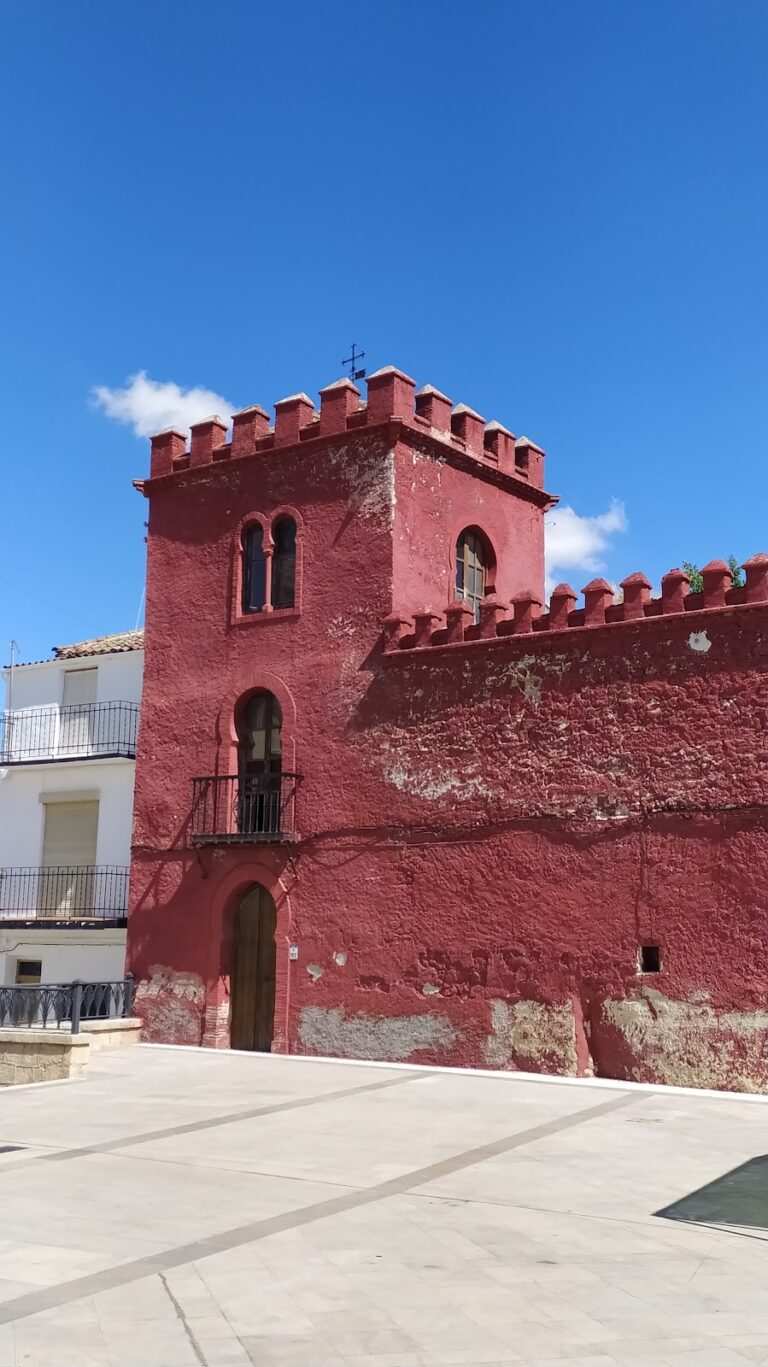
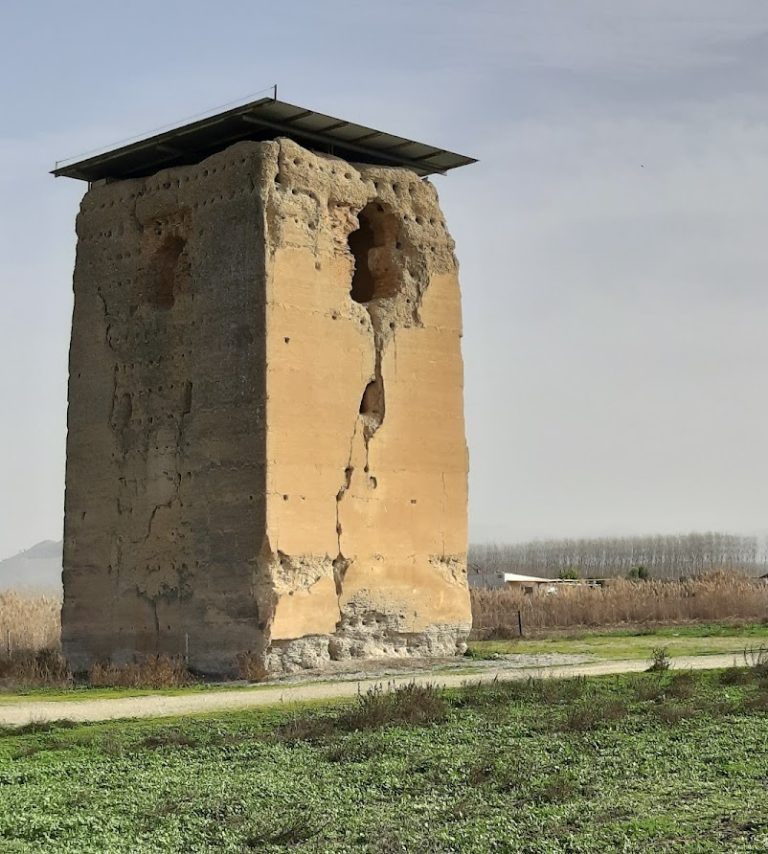
Castillo de Huétor, also known as the Torreón de Huétor, is a surviving medieval fortification in Huétor Tájar, Spain. It formed part of the defensive system of the alquería, a rural settlement in medieval Islamic Iberia, during the Nasrid period. The Nasrids were the Muslim dynasty that ruled the Emirate of Granada, the last Muslim-ruled state in the Iberian Peninsula, until the late fifteenth century. The tower belonged to the fortified settlement before the Castilian conquest and is now the last surviving vestige of the fortifications that surrounded it.
Nasrid frontier settlement
The fortress’s origin remains uncertain. Its first known mention dates from 1431, when Pedro Carrillo de Huete referred to a settlement called Hector or Vector in the Chronicle of the Falconer of John II. The reference occurred during a punitive campaign led by Álvaro de Luna, Constable of Castile, before the Battle of La Higueruela. Álvaro de Luna was a powerful fifteenth-century Castilian nobleman and royal official. Hector or Vector has been identified with present-day Huétor Tájar, although that identification is not certain.
Arabic place-name evidence has also been associated with the settlement, but these identifications remain disputed. The village called qaryat Wat in Arabic material was once linked to Huétor Tájar and is now considered more plausibly to have been Huétor Santillán. The eleventh-century Andalusi geographer al-Udri mentioned the possible names Tayarat al-Yabal, Tayarat al-Wadi, and Tayarat al-Layam. Tayarat al-Wadi has been connected with Huétor Tájar, but it is not known whether a defensive system already stood there at that time.
From fortified enclosure to residence
The tower belonged to an enclosure whose walls gradually became surrounded and occupied by houses. This process continued until approximately the beginning of the twentieth century. The surrounding walls were later demolished, and local elderly residents recalled the construction of buildings facing the parish church after their removal. Archaeological evidence has not established the tower’s origin or development, partly because extensive urban growth has hindered effective surface investigation.
Like other towers on the Granada Poniente frontier between Castile and the Nasrid Kingdom, Castillo de Huétor may have changed from a defensive structure into a residence and a marker of seigneurial authority. The seigneurial regime was a system in which territory and local authority were held by a feudal lord or noble house. The tower later housed administrators of the House of Montijo, an aristocratic Spanish family.
Later reuse and protection
After the end of the seigneurial regime, the tower ceased to serve as a residence. It was reused first as a warehouse and later as a discotheque. Modern buildings have incorporated or enclosed parts of the structure, including buildings associated with the present La Torre cafeteria. The privately owned tower has no established current use, and its physical condition was considered critical.
Castillo de Huétor is protected as a Spanish Asset of Cultural Interest in the Monument category. The protection applied to Spanish castles under the decree of 22 April 1949 and was incorporated into the cultural-heritage framework by Law 16/1985. The tower entered the General Register of Assets of Cultural Interest on 22 June 1993 under registration RI-51-0007767-00000. Andalusian heritage legislation also defines a protected setting extending 50 metres in urban land and 200 metres in developable or non-developable land.
Remains
Castillo de Huétor stands in the historic centre of Huétor Tájar, in the southern part of the town near Plaza de Andalucía, the parish church of Santa Isabel, and the town hall. It occupies a slightly raised position near the Genil River, while the former fortified area lay above a riverbank slope of approximately 6 metres. The enclosure once extended around the tower, with its walls running parallel to Santa Isabel church and continuing toward the northwest, north, and northeast. Its area included ground now occupied by Plaza de Andalucía and Plaza del Pósito.
The masonry tower
Lower level and original entrance
The tower has a slightly square plan. Its first floor measures 4.10 by 3.95 metres, with the longer side running north to south. The masonry structure rises approximately 13.50 metres and has a slight batter, meaning that the base of the wall slopes inward. Its height is divided between a solid lowest level and four upper levels, while the terrace was added later.
The lowest room is interpreted as a cistern. Its walls are 1.75 metres thick, and the room measures 3.60 by 3.45 metres internally, with the longer dimension running east to west. A concrete-beam floor now covers the space. A modern opening pierces the north wall, while two passage openings in the south and east walls appear to be earlier. A modern staircase connects the cistern with the first floor.
The first-floor room measures 4.10 by 3.95 metres. Its original entrance is in the south wall, where the arched doorway retains the upper socket that received the door pivot. The wall at this opening is 1.40 metres thick. A timber-log floor contains a trapdoor beside the north wall, which may have allowed water to be raised from the cistern through the different levels. An original staircase, 95 centimetres wide, runs along the east wall to the second floor.
Upper floors and terrace
The second-floor room follows the general arrangement and measurements of the level below. Its east wall contains a window opening, where the wall is 1.40 metres thick. A similar staircase leads to the third floor, whose internal dimensions are 4.20 by 4.10 metres. Windows open through its south and north walls, which measure 1.30 and 1.25 metres thick at those openings.
A spiral staircase in the southeast corner rises to the terrace. Its exit is enclosed by a cylindrical brick turret with a small dome. The terrace itself is a later addition to the original vertical arrangement of the tower.
Southern vaulted chambers
Three parallel chambers lie to the south of the tower. Together they measure approximately 17.50 by 3.30 metres and communicate through five arches on each side. Brick barrel vaults cover the chambers. A barrel vault is a continuous curved ceiling, and its springing line, the level where the vault begins to curve upward, lies 3 metres above the present pavement.
The chambers have exterior side walls 1.50 metres thick, end walls 1 metre thick, and intermediate walls 90 centimetres thick. The arches in the intermediate walls span 2.50 metres and rest on piers 1 metre wide. Their scale and arrangement have led to the interpretation that the complex may have been a large cistern belonging to the Fortress of Huétor.
Former enclosure
The tower was once set within a larger fortified enclosure. Its demolished walls were regarded as exceptionally hard and may have combined rammed earth with masonry. The enclosure’s alignment around the tower and its extension toward the present plazas indicate the former physical extent of the fortified area, while the surviving tower preserves only part of that earlier defensive complex.