Bolghar: Medieval Volga Bulgar City and Archaeological Complex
Site at a Glance
- Popularity
- Very High
- Country
- Russia
- Primary era
- Medieval
- Eras represented
- Classical, Medieval, Early Modern, Modern
- Civilizations
- Golden Horde, Russian
- Site type
- City
On this page27 sections
History
Bolghar is a medieval archaeological settlement near Bolgar in the Republic of Tatarstan, Russia, on the Volga River. Its earliest settlements arose around the turn of the ninth and tenth centuries, within Volga Bulgaria, a medieval polity on the Volga and Kama. Bolghar became an important center of trade and a lasting landmark in the region’s adoption of Islam.
Early settlement and growth
People occupied the surrounding area in the Mesolithic, Neolithic, Bronze Age, and Iron Age. A fortified settlement associated with the Imenkovo culture, an archaeological culture of the Middle Volga region dated to the fourth through seventh centuries, occupied a high point. A direct connection between that settlement and medieval Bolghar has not been established.
The medieval settlement began around the end of the ninth century or beginning of the tenth. Fortifications dating to the tenth century stood near the Volga at the mouth of the Little Jerusalem ravine and on the central plateau. Bolghar’s position on high ground near the meeting of the Volga and Kama offered a broad view over the surrounding region. The growth of Aga-Bazar, an important Volga Bulgar trading center, also helped draw activity to the settlement.
Bolghar was at times a capital of Volga Bulgaria, alongside Bilyar and Nur-Suvar, and an important point for trade beyond the polity. Its name is linked to the Bulgar people. The geographer al-Balkhi referred to Bolghar around 920, and al-Idrisi included the city and Volga Bulgaria on a detailed map in 1154. In the twelfth century, amid western frontier unrest and conflict with Russian rulers, the political center shifted to Bilyar. Through the tenth and eleventh centuries and into the early thirteenth, Bolghar was economically less important than Bilyar and Suvar; its settlement and suburbs covered about 12 hectares.
Trade and Islam
Bolghar’s craftworkers included jewelers, stonemasons, leatherworkers, and metalworkers. Merchants traded across Europe and Asia, dealing in goods such as jewelry, leather, furs, honey, and chain mail. An annual fair brought traders from places including China, Baghdad, Damascus, Spain, and Scandinavia. Foreign trading communities had their own streets and quarters. Before the Mongol conquest, Bolghar was an important center for external trade, and medieval writers also described it as a leading marketplace and port.
Volga Bulgaria adopted Islam as its state religion in 922. At the invitation of its ruler Almush, an embassy from the Abbasid caliph al-Muqtadir arrived that year. The Abbasid caliphate was a major Muslim empire centered in Baghdad, and Ahmad ibn Fadlan, a member of the embassy, recorded the Bulgars’ conversion. Bolghar became a religious center associated with that adoption and continues to serve as a place of Muslim pilgrimage.
A tenth-century estimate put the combined population of Bolghar and Suvar at about 10,000. Houses were described as wooden winter dwellings, while residents lived in yurts during summer.
Mongol conquest and renewed growth
The Mongols captured and destroyed Bolghar in 1236. Under Batu, a Mongol ruler associated with the founding of the Golden Horde, the city became his headquarters before the establishment of Sarai-Batu. Under Berke, a later Muslim ruler of the Golden Horde, Bolghar again became a center for the former Volga Bulgar lands and entered a period of expansion. Its built-up area grew several times over, its population increased, and craft production and coin-making flourished. Builders also raised substantial stone structures.
Bolghar was burned in 1361 by Bulat-Timur during a struggle over succession in the Golden Horde, then rebuilt. Timur, a Central Asian ruler and military conqueror, destroyed it in 1395, but it was restored again. In 1431, forces led by the Russian commander Fiodor Pestrý attacked and destroyed the city. Bolghar was subsequently abandoned and not rebuilt; Kazan became the region’s main center. The extent of the 1431 destruction is uncertain, and the campaign may have helped shift political power from Bolghar to Kazan.
Russian rule and preservation
A Russian Orthodox monastery was founded among the ruins in 1712. Its Church of the Dormition of the Mother of God was built in 1732–1734 with money from the Kazan merchant Mikhlyaev. Building the church on land formerly used by Muslim Tatars has been interpreted as part of imperial Russia’s policy of Russification. The monastery closed in 1763, while the church remained.
Peter the Great visited Bolghar in 1722 and ordered local authorities to preserve and repair surviving buildings. The order was only partly carried out. About 70 buildings may have remained at the time of his visit; 44 were counted during Catherine II’s visit, and six remained by the end of the nineteenth century. The Great Minaret was among the structures repaired under Peter’s order.
Modern study and religious importance
During the Soviet period, the church ceased to function as a place of worship and became an exhibition hall for finds from Bolghar in the 1960s. The site also became a destination for the “Little Hajj”: Muslims from Tatarstan and elsewhere in the Soviet Union who could not travel to Mecca made a pilgrimage to Bolghar instead.
Bolghar was protected as a monument in 1969, when a state historical and architectural reserve was established. Archaeological, research, and restoration work expanded in the 1970s, and restoration intensified in 1998 during preparations for UNESCO consideration. The reserve became a museum-reserve in 2000, and a broader restoration and conservation program began in 2010.
The Bolgar Historical and Archaeological Complex was added to the UNESCO World Heritage List in 2014 under criteria (ii) and (vi). The listing recognizes evidence of cultural exchange in the site’s architecture, urban planning, and landscape, as well as its association with the Volga Bulgars’ adoption of Islam. The complex is also a federal cultural heritage property in Russia. It remains a pilgrimage destination for Tatar Muslims and other Muslims of the region.
Remains
Plan and defenses
Overall layout
The archaeological complex has a roughly triangular plan, extending south from the Volga. At its height in the thirteenth and fourteenth centuries, the settlement was enclosed by a defensive circuit more than 5 km long. Early dwellings were described as wooden; stone construction became prominent in the Mongol period. Many buildings deteriorated after the city was abandoned, and surviving structures have undergone extensive restoration.
Defensive circuit
Built in the second half of the fourteenth century, the fortifications enclosed the city’s landward sides, with the Volga protecting the fourth. A water-filled moat measured 6–8 m across and about 2.5 m deep. On the southern and western approaches, four lines of pointed stakes obstructed siege engines. An earth rampart, about 6 m high, supported a timber wall roughly 2 m thick, reinforced by projecting defensive towers spaced 25–30 m apart. Gates opened to the west, south, and east.
Mosque and mausoleums
Congregational Mosque
The white-limestone Congregational Mosque stood on a rise and was completed in the 1260s. Its rectangular plan measured about 32 by 34 m. Twenty columns supported a wooden pitched roof, while plastered walls were strengthened by exterior supports. A vaulted entrance stood in the northern wall, where the Great Minaret was also positioned. At the southern end, a prayer niche called a mihrab indicated the direction of prayer and was framed with carved decoration.
Damage led to substantial changes in the late thirteenth and early fourteenth centuries. Square columns were replaced by octagonal ones, one of which survives. Work in the 1340s added decorated window and door surrounds, entrance porches, and exterior niches. Four corner towers were added after the city was burned by Bulat-Timur, and the mosque also served a defensive purpose. Surviving remains include wall sections, corner towers, foundations of the entrance and columns, and the standing column. Excavation exposed the ruins beneath later deposits; copies were made of a column and a carved stone window frame found at the site. The mosque was investigated at intervals between 1892 and 1966 and conserved in 1965–1966, 2003–2005, and 2010–2012.
Great Minaret
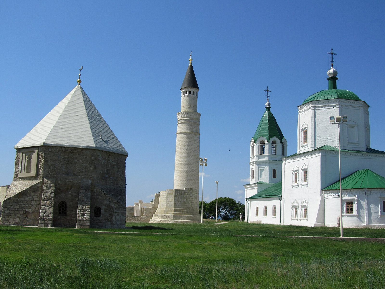
The limestone Great Minaret, a tower associated with the mosque, rose 24 m beside its northern wall. Arabic inscriptions, including passages from the Quran, adorned the tower. The original structure collapsed in 1841, leaving its foundations. A replacement built on the original base in 2000 followed old drawings and is a reconstruction, not the medieval tower.
North Mausoleum
Opposite the mosque’s main entrance, the North Mausoleum was built in the 1330s as a family tomb for Volga Bulgar notables. The limestone building measured about 13 by 18 m and had a facing of tuff, porous rock formed from compacted volcanic ash. It originally had a tent-shaped roof and a projecting entrance. Foundations and wall fragments survive from the original structure; restoration in the 1960s added a dome of stone-faced reinforced concrete. The building was later used for storage.
Stone grave slabs inside the mausoleum carry inscriptions commonly arranged in 8–12 lines. These combine Quranic passages with the deceased person’s name, several generations of ancestry, and often a precise death date, followed by another Quranic passage. Together, the inscriptions provide evidence about Volga Bulgar language, family relationships, and religious practice.
East Mausoleum
East of the mosque, the East Mausoleum was built in the early fourteenth century as a tomb for Volga Bulgar nobles, including members of the Burašbek family. White and gray limestone and light-colored tuff were used in its construction. The square base rises into an octagonal upper structure, whose sides measure about 10.8 m; a southern entrance, projecting portal, traces of decorative niches, and a surviving vault are also present.
The building was converted into an Orthodox church in the early eighteenth century. Its ventilation slits were enlarged into windows, and the interior was altered with a new entrance, plaster, heating, a base for an icon screen, and a new floor. A tombstone dated 4 June 1291 was found during restoration in the 1890s. Most of the church alterations were removed in the 1960s; a pyramidal roof was added, and an Islamic crescent was placed on it in the 1990s. Excavated finds are displayed inside. Excavation also uncovered seven decayed wooden or stone tombs, some containing human remains.
Minaret, cemetery, and palace remains
Small Minaret
The Small Minaret stands about half a kilometer south of the Congregational Mosque, near the Khan’s Tomb. Built in the second half of the fourteenth century in imitation of the Great Minaret, it combines tuff and white limestone. Its square base measures 4.8 m on each side, and the structure is about 10 m high without its roof. Two cylindrical sections rise above the base and support a conical roof. Forty-five internal steps lead to an upper space with a low circular drum. The arched entrance and niches on the western side have fine carving, with further decorative traces above.
Khan’s Tomb
The Khan’s Tomb is the best-preserved of four fourteenth-century tombs in a former cemetery north of the Small Minaret. Built of white limestone, it has a square plan measuring about 8.5 m on each side, a small dome, and no projecting entrance. It was first built in the early fourteenth century and enlarged or rebuilt around the middle of the century as part of the group of four tombs. Two walls survive almost intact, allowing the presumed original form to be reconstructed. Nearby mounds conceal the remains of other stone buildings.
Black Palace
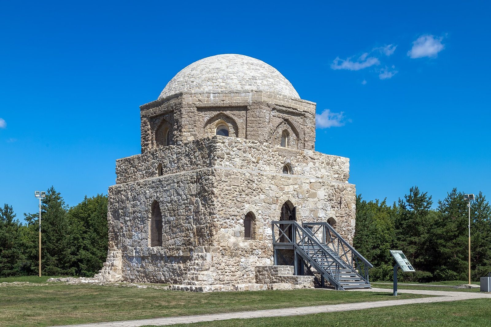
The Black Palace, also called the Black Chamber, stands about 400 m south of the mosque and roughly the same distance from the Small Minaret. Built of white limestone in the mid-fourteenth century, it is about 9.5 m high. Its square base measures 10 m on each side and rises through two storeys to an octagonal upper section and a domed roof. The central room survives, as do evidence of a larger complex, including traces of side corridors with arches, an entrance with front steps, and foundations of seven nearby buildings.
The interior is plastered and decorated with molded alabaster, including bands in profile, star-shaped rosettes, and columns with capitals. The building’s original use is uncertain; proposed identifications include a court, mosque, dervish lodge, Islamic school, or hospital. A legend says that Khan Abdullah took refuge there during Timur’s conquest and that Timur ordered it burned. In the tale, Abdullah’s daughter agreed to marry Timur to secure her brothers’ release, then killed herself in the fire. A more plausible explanation for the building’s name connects it with a smokehouse installed there in the nineteenth century. Kazan University opened a museum in the building in the 1870s.
Bathhouses and water facilities
White Palace
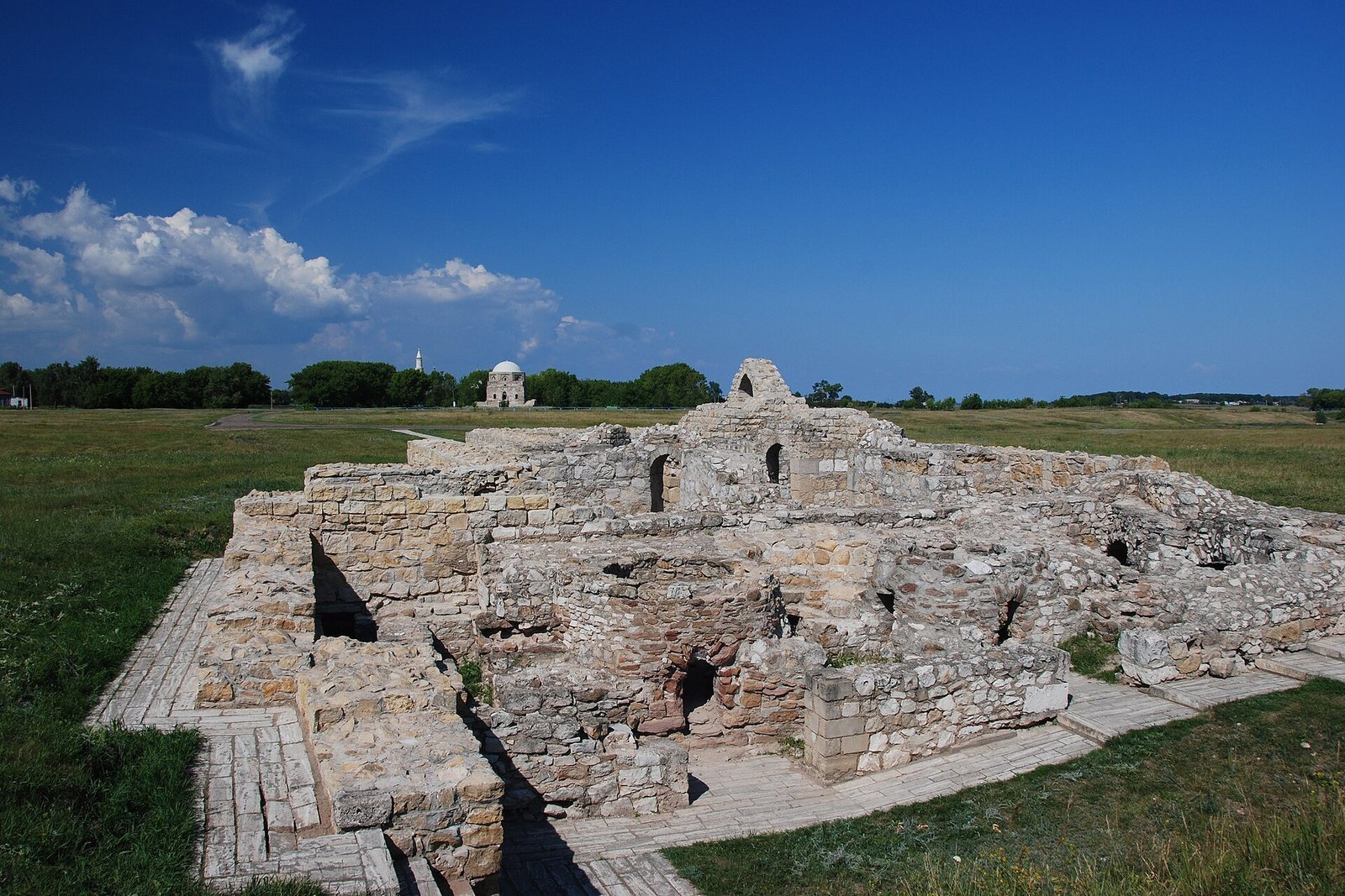
The White Palace is the surviving remains of a fourteenth-century bathhouse. Its rooms included a changing area, cold and hot bathing halls, service spaces, and separate rooms equipped with baths and fountains.
Red Palace
The Red Palace was a large public bathhouse on the lower terrace of the former Melenka River valley, north of the mosque complex. Built in the mid-fourteenth century, it measured about 30 m long and 12–24 m across. Its complex plan included red-colored interior features, and the building was destroyed in the 1430s. Its scale and decoration suggest bathing for prosperous residents, while pottery and coins found there indicate that its use was not confined to the elite. The remains were partly protected by filling them with soil and enclosing them with a stone barrier against river water.
East Chamber and other bathhouses
The East Chamber, also known as the Khan’s Baths, was among the largest bathhouses in the city. It dates to the late thirteenth century and measured about 39 m long and 11–19 m across. Other bathhouse remains include Bathhouse No. 1 on the eastern slope, Bathhouse No. 2 on the western slope, and Bathhouse No. 3 near the river; ruins survive from some of these buildings. Galanskoje Lake served as a water reservoir.
Central bath building
Excavations in 1984 uncovered a stone bath building in the central part of the site. Its remains included a furnace and heating channels, alongside pottery, coins, water pipes, and architectural fragments. Accumulated archaeological layers there exceed 3 m in depth and span remains from before the Bulgar period through deposits associated with a Russian village of the seventeenth to nineteenth centuries.
Small Town and other remains
Small Town
The Small Town is a separate complex behind the principal defensive line, near the southern gate and about 2 km from the river. Its trapezoidal plan includes two lines of defensive barriers, a surviving moat, the remains of two towers, and several buildings, some apparently unfinished. Reconstructed supports mark an entrance gate. The ruins contain tuff, limestone, sandstone, and cobblestone. Its purpose remains uncertain; interpretations include an outlying fort, a suburban residence for a khan, or facilities used by trading caravans.
Other identified features
Other named remains include the House with Towers, also identified as the Khan’s Palace; the South Mausoleum and Mausoleums Nos. 1–8; and ceramic workshops, including workshops near Galanskoje Lake. The Greek Chamber, also known as the Armenian Colony, is another named feature. A building associated with a water reservoir served ritual washing before prayer, and the Small Town includes northern and southern buildings.