Liao Shangjing: Archaeological Remains of the Liao Dynasty’s First Capital
Site at a Glance
- Popularity
- Medium
- Country
- China
- Primary era
- Medieval
- Eras represented
- Medieval
- Civilizations
- Jurchen Jin
- Site type
- City
On this page23 sections
History
Liao Shangjing is the archaeological site of the Liao dynasty’s first capital, near Lindong Town in Bairin Left Banner, Chifeng, Inner Mongolia, China. The Khitan-led Liao dynasty began building its walled capital in 918 around Longmei Palace. A foundation tradition says that Yelü Abaoji, the dynasty’s founder and first emperor, selected a place among three mountains and marked it with a golden arrow before establishing the palace there.
Before and during the Liao foundation
Before the capital was built, the area belonged to Liaodong Commandery under the Han dynasty. During Wang Mang’s rule, it was called Beianping. Its water, grasslands, and defensible terrain suited both farming and pastoral life.
In 918, Abaoji enclosed Longmei Palace within a walled city named Huangdu. It became Liao’s first capital. After the 926 campaign against Bohai, a kingdom in Northeast Asia, Abaoji enlarged the city and established Tianzan Palace. Huangdu then formally served as a Liao capital. In 938, it was renamed Shangjing, meaning Upper Capital, while its administrative center was called Linhuang.
Shangjing was one of the Liao dynasty’s five capitals, a system of centers that helped govern its large realm. The city’s recorded population was 36,500 households. Its jurisdiction included 25 military commands, prefectures, subprefectures, and cities, along with ten counties. Imperial government and administration operated alongside religious, commercial, residential, and diplomatic activity.
Tianzan Palace’s three principal halls hosted ceremonies on the first and fifteenth days of each month, as well as festivals and observances of emperors’ birthdays and death anniversaries. Officials from Liao’s eastern capital attended. A temple in the inner city’s southeast held a portrait of Abaoji’s deceased father, who was honored as Emperor Xuanjian.
Jin, Mongol, and Yuan rule
Jin forces led by Jin Taizu Wanyan Aguda captured Shangjing in 1120 and destroyed its principal buildings, including the palaces. The Jin dynasty made it its Upper Capital, then renamed it the Northern Capital in 1138. In 1150, the city’s status was lowered to the seat of Linhuang Circuit, an administrative region. Between 1201 and 1208, it was reduced again, this time to a prefectural seat.
Mongol forces took the city in 1214 and nearly destroyed it. It was not rebuilt. Under the Mongol-led Yuan dynasty, the site became an estate belonging to a meritorious official and his descendants, and formed part of a fief held by a Prince of Lu.
Rediscovery and archaeological study
A French Catholic missionary identified the ruins as Liao Shangjing in 1912. In 1920, cultivation turned part of the southern Han City into farmland and caused severe damage. Japanese excavations took place during the Second Sino-Japanese War.
In the 1950s, local authorities removed houses built within the city and barred further construction and ground disturbance. A survey and trial excavations followed in 1962. Archaeologists found numerous Liao-period cremation graves near the city during the 1980s, while aerial photographs taken in 1997 clarified its scale, layout, and component areas.
The site received national-level protection as a Major Historical and Cultural Site in 1961. A protection plan was approved in 2002. Liao Shangjing entered China’s tentative list for World Heritage nomination in 2012 and appeared in national archaeological-park project listings in 2013 and 2014.
Remains
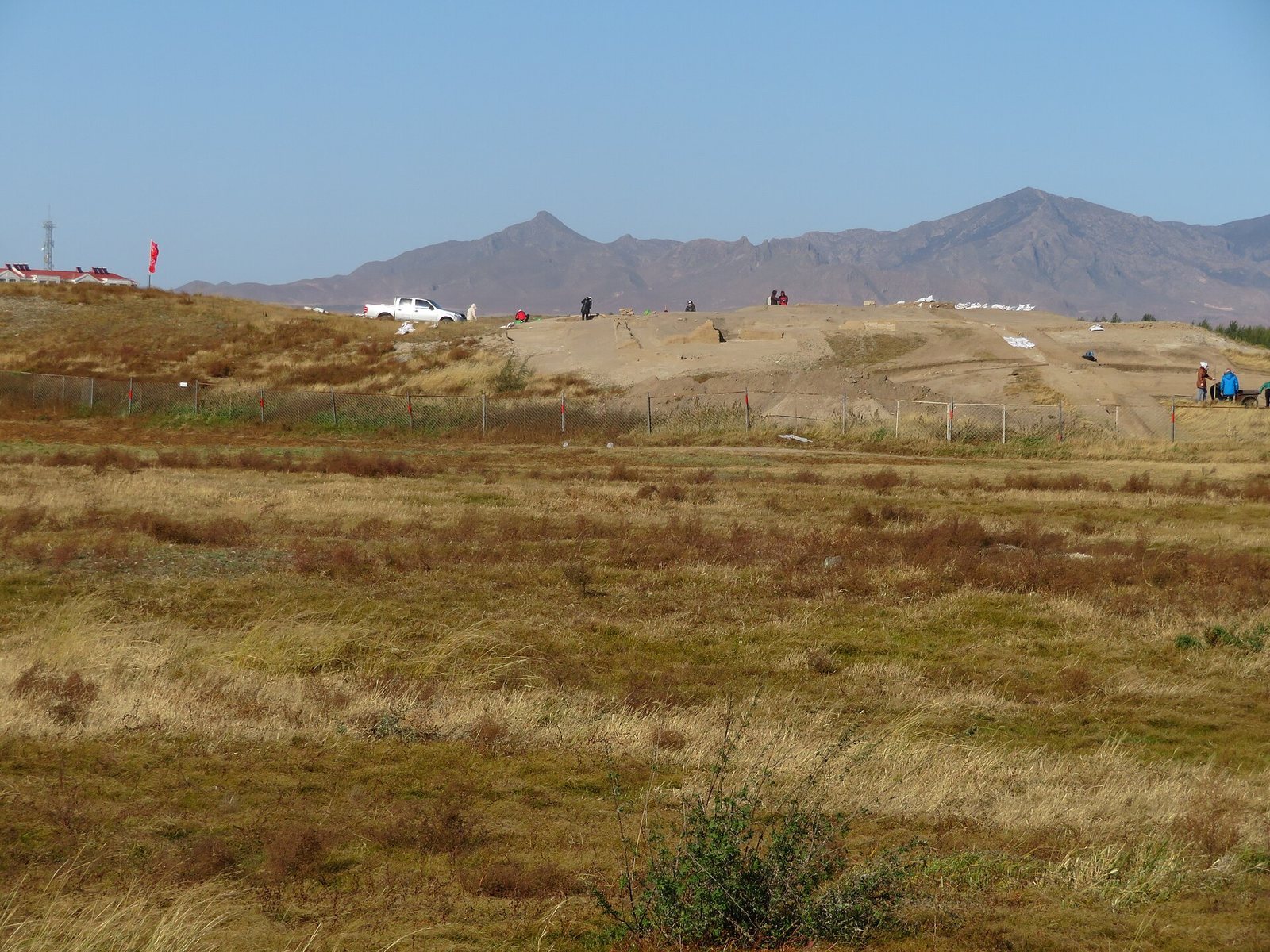
The ruins lie near the confluence of the Shali and Wu’erjimulun rivers, in a landscape that historically included rivers, lakes, marshes, and mountains. The walled city had a perimeter of 13.5 km and comprised a northern Imperial City and a southern Han City, the district associated with Han Chinese residents. River erosion now separates the two areas.
Imperial City walls and gates
Walls and defensive works
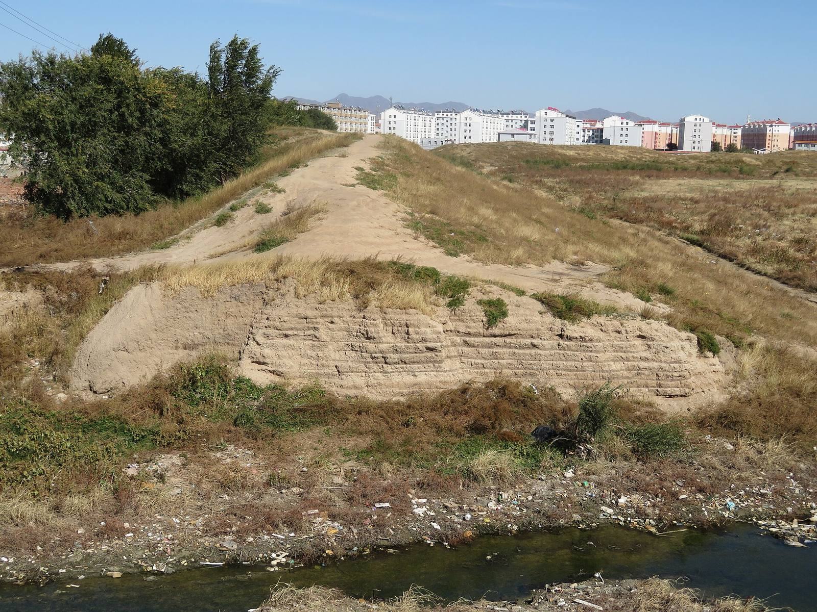
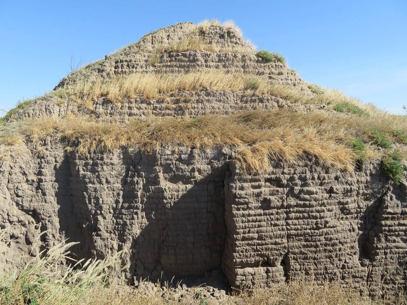
The roughly rectangular Imperial City measured about 1,700 m from north to south and 1,500 m from east to west. Its surviving walls reach 9 m in height. Projecting bastions, outward extensions of a wall used for defense, remain at intervals of about 100 m along other sections.
Gates and enclosures
The larger outer city had two gates on each side except the north. The Imperial City had a gate on all four sides, an additional gate in its inner southern wall, and east and west gates along the approaches to the palace precinct. Gate remains survive on the Imperial City’s south, west, and north sides. Defensive enclosures remain beyond its east, west, and north sides; smaller enclosures also stood outside southern, western, and northern entrances.
Palace precinct
Palace wall and main-hall site
The palace precinct occupied high ground near the center of the Imperial City, slightly south of its midpoint. The main-hall site lies at the precinct’s highest point. Sections of the enclosing wall remain. Built from rammed earth, soil compacted in layers, the wall had an above-ground body set over an underground foundation trench.
Eastern gate
The eastern palace gate is comparatively well preserved. It had three passageways: the two side passages remain in better condition, while the central passage is badly damaged. Its rammed-earth platform retains the arrangement of columns, supported by stone foundation blocks.
Western gate and surrounding buildings
The palace’s western gate stood opposite the Imperial City’s western gate, and a road connected the two. Numerous remains of buildings from the Jin period also surround the palace precinct.
City districts and streets
Imperial City districts
Administrative offices and temples occupied areas east and southeast of the palace, between it and the city wall. Offices, Buddhist temples, and workshops lay east and south of the palace, while an encampment for Khitan nobles occupied the northwest. Along the main southern street’s eastern side stood an administrative office and the Salt and Iron Gate. South of the palace area were the Imperial College, a state institution for higher learning and training officials, with a Confucian temple to its north and another temple to its east. Other districts included prefectural and county seats, Taoist temples, a temple, an empress’s former residence, and a consort’s residence. Farther south were a nunnery, a brocade office, government offices, and two granaries.
Han City
The southern Han City measured about 1,700 m from east to west and 1,200 m from north to south. Four gate sites survive, and a road from the center of its northern side led into the Imperial City. Its walls were less substantial than those farther north. Repeated shifts in the Baiyin Gol River’s course eroded the area, and surviving remains are concentrated in the city’s central northern part.
A cross-street in the Han City’s southern area had rows of buildings and shops on both sides. County seats stood near the eastern and western gates. An encampment east of the southern gate lodged Uyghur merchants. A post station to the southwest housed envoys from different states, and a further station southwest of it received envoys from Western Xia. Temples and additional county seats were distributed through the western and southern districts.
Religious monuments and sculpture
Brick pagoda
South of the city stands a hollow-brick pagoda about 25 m high. It has an octagonal plan and seven eaves, with carved images of Buddhas and bodhisattvas on each face.
Stone figure
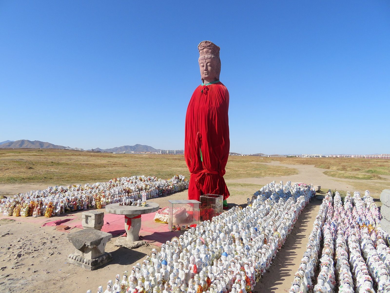
A stone figure stands between the palace ruins and the northern wall of the Han City. It has a rectangular face, a crown, a beaded necklace, and a long robe. The hands and the object it held are damaged, and the figure stands barefoot on a lotus base.
Monument bases
Two tortoise-shaped stone bases for monuments stand south of the palace ruins. Each is about 1 m high and 1.5 m long.
Excavated objects and inscription
Ceramics
Excavations in 1962 recovered many ceramic fragments from the Imperial City and pottery fragments from the Han City. The ceramics include imported white Ding ware, a type of Chinese ceramic, and local copies of its style, as well as other white porcelain and Liao-period glazed and three-color pottery.
Coin hoard
A hoard discovered in 1972 weighed about 280 kg and contained more than 60,000 copper coins. Most dated to the Han and Tang dynasties, the Five Dynasties period, or the Song dynasty. The Liao coins comprised 44 pieces in 11 types from nine reign periods. The hoard also included one coin from Western Xia and one from Goryeo.
Stone inscription
A fragmentary stone inscription found in 1999 preserves four readable characters referring to the Supreme Capital and a commandery.