Āraiši Castle: A Livonian Order Stronghold in Latvia
Site at a Glance
- Rating
- 4.5
- Popularity
- Very Low
- Country
- Latvia
- Primary era
- Medieval
- Eras represented
- Medieval, Early Modern
- Civilizations
- Crusader, Livonian Order, Polish–Lithuanian Commonwealth
- Site type
- Military
- Remains
- Castle
On this page12 sections
History
Foundation and role
Āraiši Castle is a medieval stronghold of the Livonian Order on a peninsula on the western shore of Lake Āraiši in Latvia. The Order was a Catholic military organization that governed Livonian lands and maintained castles. The castle’s construction date is uncertain, but a coin indicates that it was in use by the middle of the 14th century. It helped the Order strengthen its hold on the Gauja corridor and defend against Lithuanian incursions and neighboring strongholds belonging to the archbishopric at Straupe and Krimulda.
Āraiši guarded the southern approach to Cēsis, the principal castle of its commandery, an administrative district of the Order. It also watched an important route south through Skujene and Erla toward Koknese. As well as housing weapons and food supplies and keeping warhorses, the castle served as the center of the Āraiši parish district.
An earlier theory identified Āraiši as Old Cēsis, the first headquarters of the Livonian Brothers of the Sword. That identification was later rejected: the fortress was instead located at Riekstukalns beside Cēsis Castle. A tradition about the fortress there connected it with the order’s first master, Venno von Rohrbach, and attributed a stone castle built in 1226 to his successor, Volquin.
A church was established at Āraiši around 1225 by the mayor of Cēsis, Frülingshausen. The present church stands on the opposite side of the lake. A letter from 1546 concerned the transfer of the vicar’s office, held by a cleric serving the church, to the Āraiši priest in exchange for a horse.
Order administration and the Livonian War
A reference attributed to 1410 uses the name Arries, while the Teutonic Order’s 1438 castle-tax list provides the first secure mention of Āraiši. A document issued in 1445 by master Heidenreich Vincke von Overberg dealt with property in the Āraiši and Skujene parishes. The castle also appears in a 1467 Order list, which places it under the master’s direct authority. From 1481, the masters generally resided at Cēsis, though they sometimes stayed at Āraiši. In the 16th and 17th centuries, the castle was also called Old Cēsis, Alt-Wenden, or Stara Kies.
Master Hermann von Brüggenei signed documents at Āraiši in 1545 and January 1547 concerning a transaction linked to the church and its congregation. The castle appears again in an Order list from 1555. In 1558, during the Livonian War, a conflict over control of Livonia that lasted from 1558 to 1583, the commander at Cēsis reported that mercenaries from Āraiši and another place would be unable to reach their assigned post while local peasants were prepared for service. The following year, a Russian man suspected of spying was seized at the nearby Althusen estate.
On 14 March 1561, master Gotthard Kettler granted the nearby Bergenhof estate, later called Drabeši, and two farms to K. Viettinghof, an interpreter of Russian. After the Livonian Order’s state dissolved that year, Āraiši became an administrative center and the residence of a local starost, an official responsible for local administration. From 1561 to 1629, it was the center of a state estate formed from six vakus, local units for organizing land and peasant obligations in the former Cēsis castle district.
The castle changed hands amid the Livonian War in 1577. Hans Ernst and his associates seized it, killing some servants and taking others prisoner to castles held by Duke Magnus, a Danish prince who claimed the title of king of Livonia. The deputy starost had 40 warhorses, weapons, supplies, and livestock at Āraiši; the captors divided the prisoners’ property among themselves. Forces loyal to Magnus then occupied the castle. On 31 August, Russian and Tatar troops under Tsar Ivan IV arrived, plundered the site, and captured and deported its inhabitants to Russia.
A letter dated 16 September described the castle as already in Polish hands. In December, 400 soldiers loyal to Poland’s King Stephen Báthory, led by Johann Bühring, retook it from Russian forces. Rather than launch a direct assault, they climbed the walls at night. The fighting badly damaged the castle.
Decline and archaeological investigation
An inventory from 1582 described the castle as empty, with uncultivated land. The district had become part of the Cēsis voivodeship, an administrative province in the Polish-Lithuanian Commonwealth’s territory of Polish Livonia. By 1590, people had returned to the site and residential and agricultural buildings were in use. A ditch beyond the fields, probably linked to the outer defensive area, was partly filled, and a new tavern had been built.
The castle appears in a chronicle illustration made between 1628 and 1645, though the image is considered unreliable. It was probably abandoned in the first half of the 17th century and gradually fell into ruin. In 1701, Swedish forces under King Charles XII rested around Lake Āraiši after driving Saxon troops from Cēsis, while traveling from Pärnu toward Riga.
The castle area belonged to the Āraiši pastorate in 1922. Archaeological excavations led by Jānis Apals in 1972–74 and 1981–92 exposed the western wing across 3,320 square metres. Investigations in the 1980s also examined two lakeshore areas. In July 2012, Artūrs Tomsons led further work in the outer defensive area and along the shore.
Remains
Layout and defenses
The castle stands on a low rise at about 120 metres above sea level, on a peninsula covering roughly nine hectares. The main castle occupied the peninsula’s northeastern side, while an outer bailey, or larger outer ward, extended across most of the remaining ground. Ditches also separated the peninsula from the surrounding land.
Main castle and entrance
The inner castle had an irregular plan and a courtyard enclosed by a nearly square curtain wall, the wall enclosing the castle’s inner area. Each side measured about 81 metres. Built from large fieldstones set in lime mortar, the wall was about two metres thick at its base and 1.8 metres thick five metres above ground. Squared fieldstones formed the corners.
A gateway 3.7 metres wide stood at the center of the western wall. A drawbridge crossed the defensive ditch to the entrance. In front of the gate was a rectangular defensive structure measuring 10 by 7.85 metres. Red brick and roof-tile fragments in its mortar indicate that it belongs to a later building phase.
Outer defenses and ward
On the western, landward side, a ditch ran for about 125 metres. It was 19 to 20 metres wide and six metres deep. A bridge and dry ditches connected the main castle with the outer bailey. Together, the castle and its ditch covered about one hectare, while the outer ward covered nearly eight hectares. The ward appears to have had little fortification, if any, and may have been used to graze horses.
Surviving walls and rampart
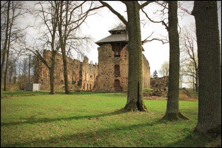
The rampart and substantial conserved sections of wall remain. The western side, including the gate, is best preserved, with surviving wall sections about two to 5.5 metres high. In spring, water partly fills the ditch in front of the entrance.
Buildings and historical depictions
Residential and service buildings
Excavations identified residential and service buildings along the inside of the western wall. A stone building in the southwest corner measured nine by 14.6 metres and included a cellar. In the northwest corner, a larger stone building measured nine by 36 metres. It had two storeys, a cellar, and three ground-floor rooms, one used to store grain. Furnaces used hypocaust heating, which circulated hot air beneath floors and through wall channels, warmed its living quarters. Other economic buildings stood against the outer defensive wall, and the courtyard between the buildings was cobbled.
Inventory and depictions
An inventory from 1590 describes a white house with two living rooms and a corridor, a granary, two cattle sheds, stables for horses, and a bathhouse. It also lists two sheds outside the walls. The illustration made between 1628 and 1645 shows two round towers, each about five storeys high, at diagonally opposite corners, as well as a low, semicircular gate tower; its depiction is not considered reliable. A Swedish military camp plan dated 28 June 1701 shows a large gabled building wing along the castle’s northern side.