Forte da Vera Cruz de Itapema: A Portuguese Colonial Coastal Fort
Site at a Glance
- Country
- Brazil
- Primary era
- Early Modern
- Eras represented
- Early Modern, Modern
- Civilizations
- Portuguese
- Site type
- Military
- Remains
- Fort
On this page8 sections
History
Forte da Vera Cruz de Itapema is a Portuguese colonial coastal fort on Santo Amaro Island, Brazil, opposite Santos. Its construction date is uncertain, but it appears on Luís Teixeira’s map of São Vicente from about 1573 and on João Teixeira Albernaz the Elder’s 1631 map of the Captaincy of São Vicente.
Early records and command
In the second half of the sixteenth century, the fort was known as Forte do Pinhão da Vera Cruz. Other names included Forte da Vera Cruz, Forte da Santa Cruz, and Forte de Itapema. Itapema comes from a Tupi-Guarani expression meaning “split stone.” Its first commander was Captain Francisco Nunes Cubas, a nephew of Brás Cubas, the Portuguese colonial settler and official who founded Santos.
Captain-major (a rank in the Portuguese military hierarchy) Pedro Tacques de Almeida oversaw renovation and expansion in 1670. By 1680, command belonged to Sergeant-major (a rank in the Portuguese military hierarchy) Gaspar Leite Costa, whose surname may instead have been César. A royal patent, a formal grant of office, appointed José Tavares de Siqueira captain in 1687, with an annual salary of 40,000 réis, the Portuguese monetary unit. Another patent, issued on July 6, 1699, appointed Domingos da Silva Monteiro, who remained in command until his death in 1723.
Rebuilding under the Carvalho family
After Monteiro’s death, Torquato Teixeira de Carvalho was recommended for promotion to sergeant-major and appointed commander in September 1724. A wealthy merchant, he offered to rebuild the fort at his own expense and supply its artillery. In exchange, he sought the captaincy and its salary, lifelong command, and membership in the Order of Christ, a Portuguese military-religious order, for three successive holders. The Crown accepted his proposal, and the rebuilding took about a decade. A royal provision, a formal decree, dated September 24, 1738, confirmed his captaincy in recognition of the work.
Command then passed to Torquato’s son João Teixeira de Carvalho, his nephew Captain Francisco Olinto de Carvalho, and Francisco’s son, João Olinto de Carvalho. In a report dated June 30, 1770, Governor and Captain-General Luís António de Sousa Botelho Mourão stated that the fort had eight guns, four firing 12-pound shot and four firing 8-pound shot.
Nineteenth-century decline
A royal order of January 28, 1811, removed Colonel José Antônio Vieira de Carvalho from command at Itapema and returned him to the Fort of Bertioga. Repairs to Itapema’s equipment rooms followed an order issued on May 22, 1817. During wartime in 1830, the garrison comprised one senior officer, two junior officers, eight artillerymen, 24 artillery attendants, and 20 infantry soldiers. By 1839 the fort had fallen into severe disrepair, with just one family stationed there.
The fort was disarmed in 1850 and converted to a storehouse. A major fire in July 1883 left it in ruins. Painter Benedicto Calixto depicted the remains in the early twentieth century.
Customs and later uses
In 1905, the General Intendancy of War transferred the property to the Customs House of Santos. From 1908, Customs used the site for a fiscal post and a floodlight tower to illuminate the estuary and deter smuggling. During the Second World War, the fort guarded the estuary channel; afterward, it served as a medical post. A further fire damaged these installations in 1976.
In 1982, the State of São Paulo designated the property as cultural heritage under the title “Fortress of Itapema, Lighthouse and Annexes.”
Remains
Fortifications at the water’s edge
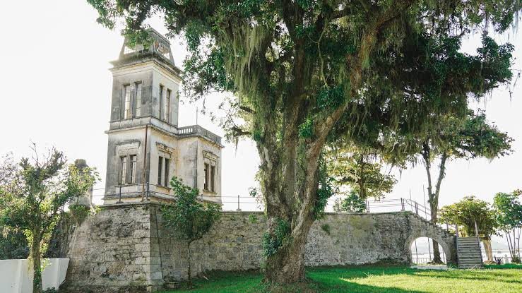
The fort stood on rocks at the edge of the water, on a point of Santo Amaro Island about one league within the Barra Grande channel. A league was a historical distance unit whose length varied by region. The walls gave a view across the settlement of Santos. The rebuilt fort included a bastion, a projecting part of a fortification, and buildings sheltered by an earthwork platform, a level raised area behind a fort’s protective wall. By 1811 it had walls with parapets (protective walls) and a powder house; its equipment rooms were repaired in 1817.
Later alterations and associated buildings
In 1908, compartments within the raised platform were filled, and the wall’s notched upper edge was replaced by an iron railing. A floodlight tower was also added and later described as a lighthouse. At the end of 2001, the complex included the lighthouse tower, a caretaker’s house, a Customs observation post, a Museum of Laboratory Samples, a shipyard workshop, and a dry dock with capacity for up to eight boats.