Gnezdovo: A Viking Age Trading Center and Burial Complex in Russia
Site at a Glance
- Popularity
- Very High
- Country
- Russia
- Primary era
- Medieval
- Eras represented
- Iron Age, Classical, Medieval, Early Modern
- Civilizations
- Unclassified
- Site type
- City
On this page17 sections
History
Early occupation and foundation
Gnezdovo is an archaeological complex in Gnezdovo, Smolensk Oblast, Russia. It developed as a major settlement and trading center during the Viking Age, the period of Scandinavian overseas activity from the late eighth to the eleventh century. Most of its burial mounds were built between the tenth and early eleventh centuries, when the settlement was at its height.
People occupied the area long before Gnezdovo took shape. Fortified settlements associated with the Dnieper-Dvina culture, an archaeological culture of the upper Dnieper and western Dvina region, date to the first millennium BC. An unfortified farming settlement stood near the Dnieper in the fourth century AD, followed by a sequence of settlements linked to the Tushemlya culture, an early medieval culture of the Upper Dnieper region, between the fourth and seventh centuries.
The central settlement was founded around the late eighth or early ninth century by Slavs associated with the Romny culture, an early medieval culture linked to Slavic communities. They came into the Upper Dnieper region from the south along the Sozh River. Beside Lake Bezdonka, a wooden structure began to be built in the last quarter of the eighth century, although the dating ranges for this early phase are broad.
A diverse trading center
Gnezdovo’s inhabitants included Slavs, Scandinavians, and Baltic peoples. Possible connections with Great Moravia, a ninth-century Slavic polity in Central Europe, and with Finno-Ugric peoples have also been proposed. The relative size of these communities and which group predominated remain debated. Burial evidence points to differences in social position, including warriors, craftspeople, and people of high rank.
Trade and craft production shaped the settlement’s activities. Early exchange followed a west-to-east route connecting the Western Dvina, Dnieper, Oka, and Volga. From the mid-tenth century, the Dnieper route linking the Baltic region with Byzantium, the Eastern Roman Empire centered on Constantinople, became a principal artery. Finds indicate contacts with Scandinavia, the Baltic region, the Arab world, and Byzantium.
The fortified center served as a place for craft production and trade, as well as a station where a ruler’s retinue could stay and tribute could be collected. Its position near portages, where boats or goods could be moved between waterways, brought travelers and merchants through the area. The defenses have also been interpreted as protection for people and commerce at vulnerable points along the route.
After 930, pottery made on a turning wheel became more common, and the settlement expanded. Its population in the second half of the tenth century has been estimated at about 800 to 1,000 people. Burial practices changed over the same period: cremation was prevalent in tenth-century mound burials, while burials of uncremated bodies appeared from the second half of the century. About 85 late-tenth-century burials have been tentatively associated with people who may have undergone incomplete baptism.
Fire, political change, and decline
Several fires affected the central fortified settlement during the tenth century. A major fire is dated to the second quarter or middle of the century, and another substantial blaze to the middle through third quarter. Buildings burned again in the 950s. A military defeat in the 950s or early 960s may have accompanied destruction and the removal of the local elite; the disappearance of a group of hoards from this period has been cited as evidence of upheaval.
The settlement was quickly rebuilt after the mid-century destruction and prospered in the decades that followed. Changes in material culture and archaeological finds point to closer ties with Kyiv. Gnezdovo may have become more directly subject to the authorities of Kievan Rus, an early medieval polity centered on Kyiv, during Princess Olga’s rule and the organization of tribute-collection districts. The extent and timing of this relationship are uncertain.
Gnezdovo’s relationship with Smolensk is also disputed. One interpretation considers Gnezdovo the earlier economic and functional center of Smolensk, with those functions later transferred to the present city site. Another holds that Gnezdovo and a Krivich center at Smolensk coexisted during the ninth and tenth centuries. In this view, Gnezdovo served as a Kyiv-aligned trading and tribute station, while Smolensk was a regional Slavic center. Administrative, craft, and trade functions shifted toward Smolensk in the early eleventh century.
A fire and evidence of fighting are associated with Gnezdovo’s decline around the turn of the tenth and eleventh centuries, but the evidence does not establish whether the center was violently destroyed or transferred elsewhere. Tree-ring dates from one excavated area extend to 1002, and evidence there places the end of the early urban phase no earlier than the 1020s or 1030s. Activity at Gnezdovo diminished in the early eleventh century.
Later use and archaeological study
The central fortified site remained active in some form between the twelfth and seventeenth centuries. It may have been the location of a feudal estate, and a Catholic priest’s residence stood there by the seventeenth century. The original name of the early settlement is unknown. The current name is thought to have been recorded in the fifteenth century and appears in a 1648 land dispute. Proposed earlier names include Svinechsk, reconstructed from the Svinets River, and the Old Norse Sýrnes, meaning Swine Promontory; both identifications remain hypotheses.
Archaeological attention began in 1867, when railway workers uncovered a hoard of silver ornaments during construction of the Orel-Vitebsk railway. The hoard went to the Hermitage, and workers found two more hoards in 1870. In 1874, archaeologist M. F. Kustsinsky excavated fourteen burial mounds. Finds including a Carolingian sword and a Scandinavian spearhead brought wider attention to the complex.
V. I. Sizov led a major excavation campaign from 1881, continuing fieldwork until 1901 and excavating more than 500 mounds. In the 1920s, archaeologist A. N. Lyavdansky prepared a detailed plan of the complex and its mound groups and identified the Central and Olshansky settlements. During the German occupation in 1942, archaeologist Klaus Raddatz examined mounds and removed finds to Berlin; those objects were probably destroyed in the city’s 1945 bombing. Finds held in the Smolensk museum before the war were also destroyed or lost their documentation, and wartime military digging damaged parts of the burial area.
Systematic postwar research began in 1949 with the Moscow State University Smolensk Archaeological Expedition. Under D. A. Avdusin, it excavated about 700 burials. T. A. Pushkina worked at Gnezdovo from 1973 to 2020. From 1995, a joint expedition of Moscow State University and the State Historical Museum investigated both the settlements and burial grounds, led by Pushkina and V. V. Murasheva. Excavation and monitoring have continued.
The burial mounds received state protection in 1960, followed by a regional decision in 1961. A regional measure in 2007 set the archaeological site’s boundaries and protective zones, and a historical, archaeological, and natural museum-reserve was established in 2011. The complex is a nationally significant archaeological heritage site. Quarrying, cemetery expansion, construction, and looting have damaged the remains; a 2016 assessment described extensive destruction in the Central burial group. In 2015, the regional administration proposed nominating Gnezdovo for UNESCO World Heritage status.
Remains
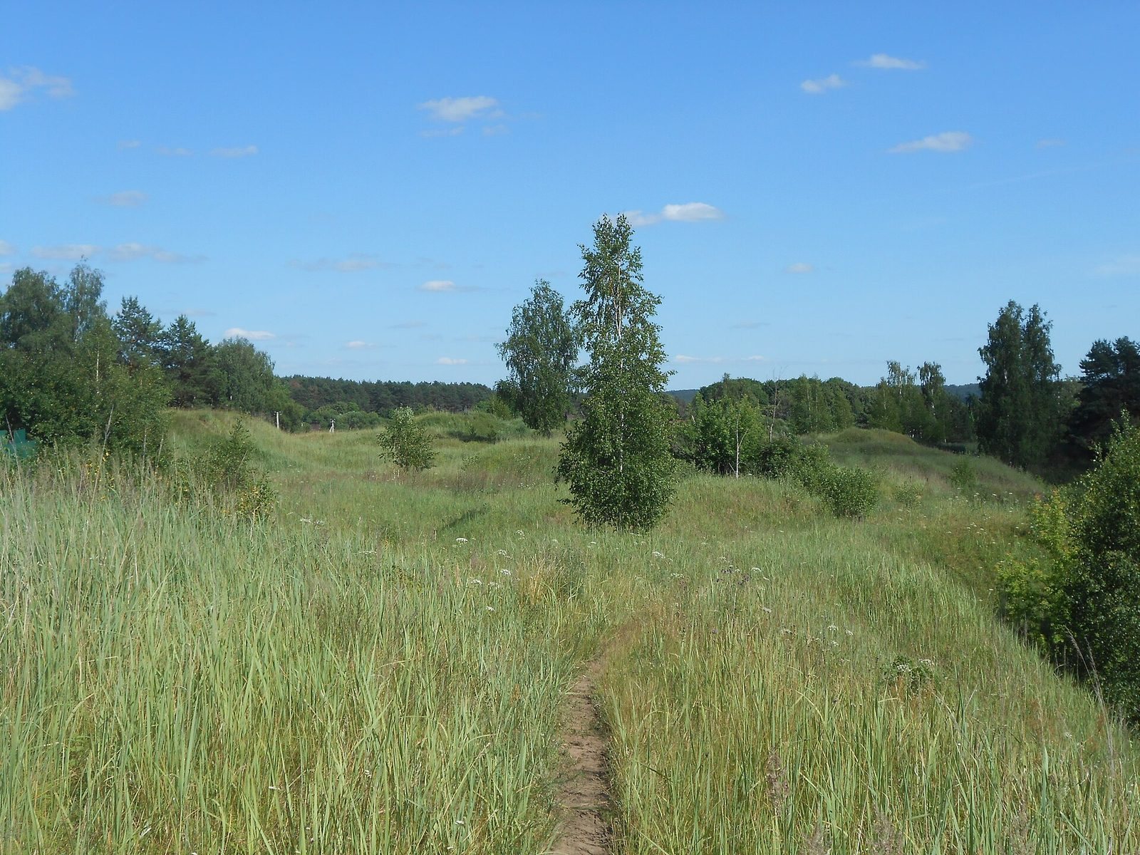
The 207.4-hectare archaeological landscape lies on both banks of the Dnieper, about 11 to 15 kilometers west of central Smolensk, between the Svinets and Olsha waterways. Its historical core was near the confluence of the Svinets and Dnieper. The remains include two fortified settlements, four unfortified settlements, and extensive burial grounds. The ancient settlement areas covered at least 30 hectares.
Settlement remains
Central fortified settlement
The Central fortified settlement occupies a projecting area of high ground on the left bank of the Svinets, above the Dnieper floodplain. Dating to the tenth and eleventh centuries, it covers about one hectare. Its defenses, first built in the early tenth century, included a ditch on the landward side, earthen ramparts, and a palisade, a defensive fence of upright posts. The terrace slopes were also cut back. An adjoining unfortified area is estimated at about 16 hectares, while the broader central settlement area is given as about 20 hectares. More than 6,000 square meters of the central settlement have been excavated.
Lake Bezdonka settlement
Beside Lake Bezdonka, in the floodplain below the fortified settlement, the earliest archaeological layers include traces of a palisade represented by 46 post remains. A nearby structure used boards and logs from both deciduous and coniferous trees, arranged at right angles but not joined into a log building. Glass beads and fragments of handmade pottery were found inside it.
Olshansky fortified settlement
The Olshansky fortified settlement dates to the seventeenth century and covers about 1.5 hectares. It forms one of the two fortified settlements within the archaeological complex.
Burial grounds
Mound groups and distribution
The complex originally contained an estimated 4,500 to 5,000 burial mounds, of which about 1,700 survive; more than 1,200 burials have been excavated. The named groups are Central, Forest, Dnieper, Olshansky, Right-bank Olshansky, Left-bank, Zaolshansky, and Nivlyansky. The Central group covers about 28 hectares and the Forest group about 17 hectares. The earliest groups lay around the Central settlement, while later groups formed along the Dnieper.
Six particularly large mounds, associated with high-status burials, are concentrated in the Central, Dnieper, and Olshansky groups. They measure about 5 to 8 meters high and 25 to 37 meters across. Examples include mounds 20, 74, and C-2 in the Central group and mound 86 in the Dnieper group.
Burial forms
The burial grounds include cremations beneath mounds, burials of uncremated bodies, wooden chamber graves, log-built graves, and burials in boats. About 52 percent of recorded burials are cremations and 31 percent are burials of uncremated bodies. Some mounds held paired cremations, and a few burials included both a warrior and a horse. Chamber graves occur throughout the burial groups, often near their boundaries.
Craft, trade, and other finds
Craft production and imported goods
Evidence from the complex includes jewelry-making, pottery-making, bone-working, and ironworking. Imported and traded objects include Arab and Byzantine coins, weights and scales, glass and stone beads, silk textiles, slate spindle whorls, glass and glazed vessels, household utensils, weapons, and jewelry. Scandinavian-style pendants and women’s ornaments, including oval brooches, occur alongside local and hybrid styles. The combined burial and artifact evidence points to Scandinavian, Slavic, Baltic, and other cultural connections, although objects alone cannot establish the origin of a particular person buried at Gnezdovo.
Inscriptions and religious objects
A Crimean amphora from mound 13 in the Forest group bears an early Cyrillic inscription. It was found in 1949 and is dated to the second quarter or middle of the tenth century. The word is read as gorušna and has been interpreted as referring to mustard, though that reading is disputed. Other finds include an Iranian bronze lamp shaped as a woman’s head and a tenth-century Byzantine devotional pendant from Syria showing the Virgin of the Sign, an image of Mary with raised hands and Christ before her. A Byzantine dish carries an image of Simargl, a figure in East Slavic religious tradition whose precise identity is uncertain. Three carnelian ring settings from mound L-210 bear Arabic inscriptions.
Weapons, burials, and hoards
Weapons and military equipment include Carolingian swords, spearheads, helmets, battle-axes, chain mail, and armor plates. A burial from 2017 contained a sword with a man estimated to have been 60 to 70 years old. A separate sword, driven vertically into the ground as far as its crossguard, was found that year with burned human bones in the northeastern part of the Central settlement.
Mound L-210 contained a cremation burial of a man and two women, accompanied by a sword, a spear, two gold bars, silver and gold garment braid, 20 Arab dirhams, and a Byzantine gold coin. The weapons and garment fittings date to the second quarter of the tenth century; the coins range from the second half of the eighth to the first half of the ninth century. Dirhams were silver coins used across the Islamic world and traded widely beyond it.
Gnezdovo has yielded numerous coin hoards and deposits combining coins with other objects. The dates when some were buried are uncertain: vessel forms place the 1973 coin hoard and the 2001 mixed hoard no earlier than the late tenth or early eleventh century, while earrings from the 1993 hoard point to a date no earlier than that period. Bead evidence places the 1870 hoard in the last quarter of the tenth century. A hoard found in 2010 included a coin minted in 953 or 954 as its latest coin, and every dirham in it had a silver purity of at least 90 percent.
Other objects reflect activity in later periods. A stylus found in 2013 is attributed to the twelfth or thirteenth century; two more, found in 2014, came from layers dated to the late tenth or early eleventh century.