Band of Holes: An Archaeological Formation in Peru
Site at a Glance
- Rating
- 4.2
- Popularity
- Very Low
- Country
- Peru
- Primary era
- Unclassified
- External website
- Open
- Eras represented
- Unclassified
- Civilizations
- Unclassified
- Site type
- Economic
On this page7 sections
History
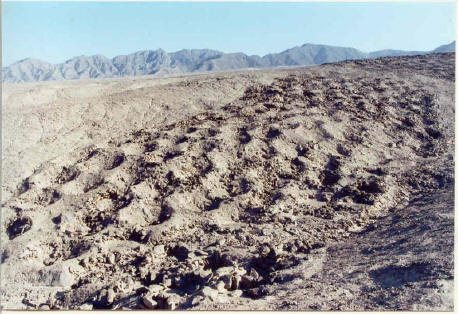
The Band of Holes is an archaeological formation in the Pisco Valley of southern Peru, near Ica, whose builders and original purpose remain uncertain. Also known as Monte Sierpe, or “serpent mountain,” and Cerro Viruela, or “smallpox hill,” it consists of thousands of pits extending across the Nazca Plateau. Proposed explanations have included pre-Inca graves, defensive positions, storage facilities, ritual or administrative installations, and structures connected with accounting and trade.
Early interpretations
Aerial surveys had recorded the formation by 1931. Aviator Robert Shippee brought it wider attention in 1933 by publishing an aerial photograph in National Geographic. Victor Wolfgang von Hagen surveyed the area in 1953 and interpreted the pits as unused pre-Inca graves. He compared them with stone-lined graves containing mummies, textiles, and pottery, and suggested that Inca engineers had filled in pits obstructing a road before building the route over or through them.
Archaeologists Dwight Wallace and Frederic Engel revisited the site during the early 1970s. Their work formed part of a continuing effort to clarify the date and function of a formation whose unusual layout had encouraged several competing interpretations.
Inca-period hypotheses
In 1984, archaeologist John Hyslop proposed that the pits might have served as storage units. He compared them with circular storage structures at Tambo Colorado and Quebrada de la Vaca. The Band of Holes lies between the important Inca sites of Tambo Colorado and Lima la Vieja, near the junction of the Inca coastal road and the route to the highlands. The Inca Empire was the Andean state that ruled much of western South America from 1438 until the Spanish conquest in the sixteenth century, using administrative systems for storing goods, collecting tribute, and managing long-distance roads. Hyslop suggested that the formation could have been one of the empire’s larger storage sites.
Archaeologists from UCLA made a brief investigation in 2015 and created a detailed map from drone photography. They proposed that the pits may have measured quantities of produce delivered to the Inca state as tribute. Under this interpretation, administrators could have recorded the quantities with khipus, Andean recording devices made from knotted cords, and communicated the information to government officials. Pollen and phytolith analysis was proposed as a way to test the idea. Phytoliths are microscopic silica remains formed in plant tissues that can help identify plants once stored or used at an archaeological site.
A study published in 2025 proposed that Monte Sierpe initially functioned as a barter marketplace and was later adapted as an accounting device for collecting tribute. This interpretation remains a hypothesis requiring further investigation. The site is supervised by Peru’s Ministry of Culture and protected as an archaeological monument.
Remains
Layout and construction
The formation extends for approximately 1.5 kilometers along an almost north-south axis. It begins at the edge of the Pisco Valley and climbs a low ridge or slope across uneven terrain. The band varies from approximately 14 to 22 meters in width, with an average width of about 19 meters, and is divided into distinct blocks or segments.
Stone-lined pits
Approximately 5,000 to 7,000 human-sized pits make up the formation. They are generally circular, lined with stone, about 1 meter in diameter, and between 50 and 100 centimeters deep. Slightly raised edges surround the pits. Von Hagen described them as arranged in rows of seven to nine ascending a slope of approximately 50 degrees, a description that emphasized their regular arrangement without establishing their definitive function.
Routes and landscape setting
The Band of Holes occupies a low ridge in the Pisco Valley near the historical route linking the coastal road with the highlands. Its position between Tambo Colorado and Lima la Vieja, and near the junction of these routes, has shaped interpretations connecting the formation with storage, trade, and Inca state administration.