Mohenjo-daro: A Planned Indus Valley City in Pakistan
Site at a Glance
- Rating
- 4.4
- Popularity
- Medium
- Country
- Pakistan
- Primary era
- Bronze Age
- External website
- Open
- Eras represented
- Bronze Age, Classical
- Civilizations
- Indus Valley
- Site type
- City
On this page13 sections
History
Mohenjo-daro is a major urban centre of the Indus Valley Civilisation in Sindh, Pakistan, built around 2500 BCE during the Bronze Age. The city flourished for several centuries and was abandoned by about 1700 BCE, while its mature urban phase is generally placed around 2600–1900 BCE. It was broadly contemporary with the civilisations of ancient Egypt and Mesopotamia. The ancient name is unknown, and the modern name is commonly interpreted as “Mound of the Dead,” although other explanations have been proposed.
Urban development and decline
Mohenjo-daro was built on a raised Pleistocene ridge near the western bank of the lower Indus, in a floodplain environment that shaped its construction and later history. The city underwent repeated building and rebuilding. At least nine occupation layers have been identified, with evidence of flooding in several levels. Earlier interpretations described a succession of cities built one above another, while later interpretations understand the remains as successive phases of construction and reconstruction within a continuously changing urban settlement.
At least three destructive floods affected the excavated levels. Other interpretations propose a series of smaller floods rather than one final inundation. The city’s decline may also have involved changes in the Indus river system, environmental and agricultural stress, declining irrigation efficiency, depletion of fuel resources, earthquakes, disease, internal disruption, or attacks. No single explanation has been established. During the later stages, substantial buildings were replaced or covered by smaller and poorer structures. The former urban and possibly administrative centre gradually became a less prosperous settlement before final abandonment.
Groups of human remains found in several parts of the city have been interpreted as possible evidence of violence. One group comprised thirteen men, one woman, and one child, while other discoveries included five bodies at a street corner, six in a street, one isolated body, and nine placed hurriedly in a pit. These finds became associated with older theories of an attack around 1500 BCE, but the role of external invaders in the city’s destruction remains uncertain.
Economy, society, and belief
The city supported agriculture, craft production, and long-distance exchange. Wheat, barley, sesame, peas, and cotton were cultivated, and cotton fibre and dyed cotton cloth were found at the site. Trade connected Mohenjo-daro and the wider Indus region with Mesopotamia and other areas. Cotton, textiles, copper, ivory, beads, shell goods, and other products formed part of the documented or proposed exchange network.
Boats and river transport were important, while bullock carts were widely used on land. A camel skeleton was found deeply buried at the site, but a horse skeleton belongs to a period after the city’s main florescence. The evidence therefore favours boats and bullock carts as the principal forms of transport during the urban peak.
The city’s political organisation remains uncertain. Its large public works, flood-control platforms, standardised weights and measures, and planned infrastructure indicate substantial organisation, but the precise institutions that directed them are unknown. Earlier interpretations proposed a religious monarchy or a central administrative authority, while other interpretations have suggested a more collective urban system. None of these models has been proven.
Religious beliefs are also difficult to identify because the Indus script remains undeciphered. Ritual bathing, sacred trees, female figurines, animal imagery, and the seal known as Pashupati have been interpreted in religious terms. Proposed connections with later Hindu deities or practices remain hypotheses rather than established identifications.
Rediscovery and preservation
Mohenjo-daro was rediscovered through surveys and excavations in the 1920s. R. D. Banerji, an Archaeological Survey of India officer, investigated a Buddhist stupa on the mound in 1919–1922 and found artefacts including a flint scraper and a seal comparable to examples from Harappa. These discoveries established the great antiquity of the site. Large excavation campaigns followed under Kashinath Dikshit, John Marshall, D. K. Dikshitar, Ernest Mackay, Mortimer Wheeler, Ahmad Dani, F. A. Khan, and George Dales.
Major campaigns took place during the 1920s and 1930s, in 1945, and in 1964–1965. After 1965, extensive excavation was restricted because exposed structures were deteriorating. Later work concentrated on salvage excavation, surface survey, architectural documentation, conservation, and limited probing. Dry-core drilling in 2015 indicated that the archaeological site extends beyond the area already excavated.
Excavation at Mohenjo-daro and Harappa helped establish the existence and scale of the Indus Valley Civilisation and transformed understanding of South Asian urban history. UNESCO, the United Nations Educational, Scientific and Cultural Organization, inscribed the site on the World Heritage List in 1980. It was the first South Asian site to receive that designation.
A Buddhist stupa was constructed on the elevated mound during the second or third century CE, long after the Indus-period city had been abandoned. Associated Buddhist buildings were probably present. Conservation has continued to face difficult conditions, including groundwater salinity, erosion, unsuitable restoration, and the collapse or undermining of walls. UNESCO-supported conservation funding was agreed in Paris on 27 May 1980. Work was suspended in December 1996 after Pakistani and international funding ceased and resumed in April 1997, while responsibility for preservation passed to the government of Sindh in 2011.
Remains
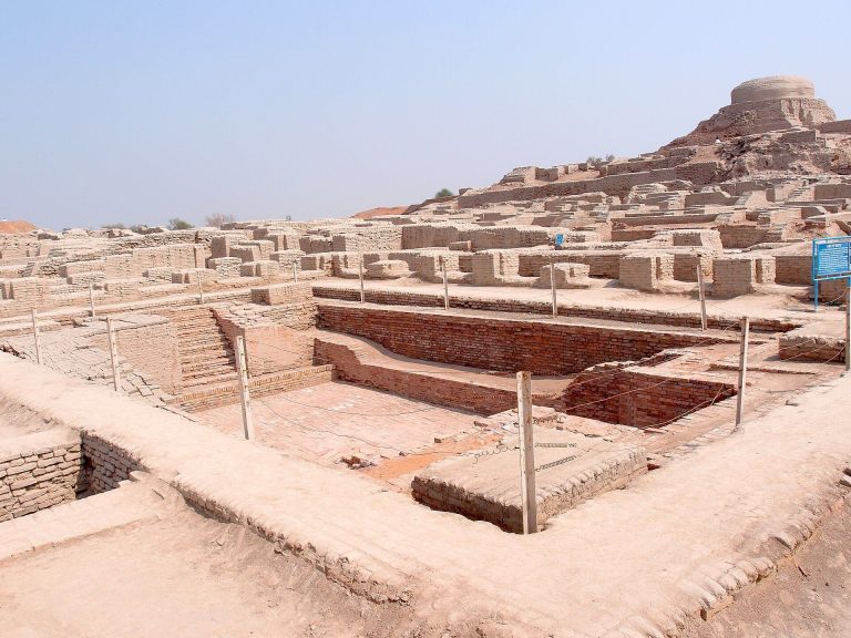
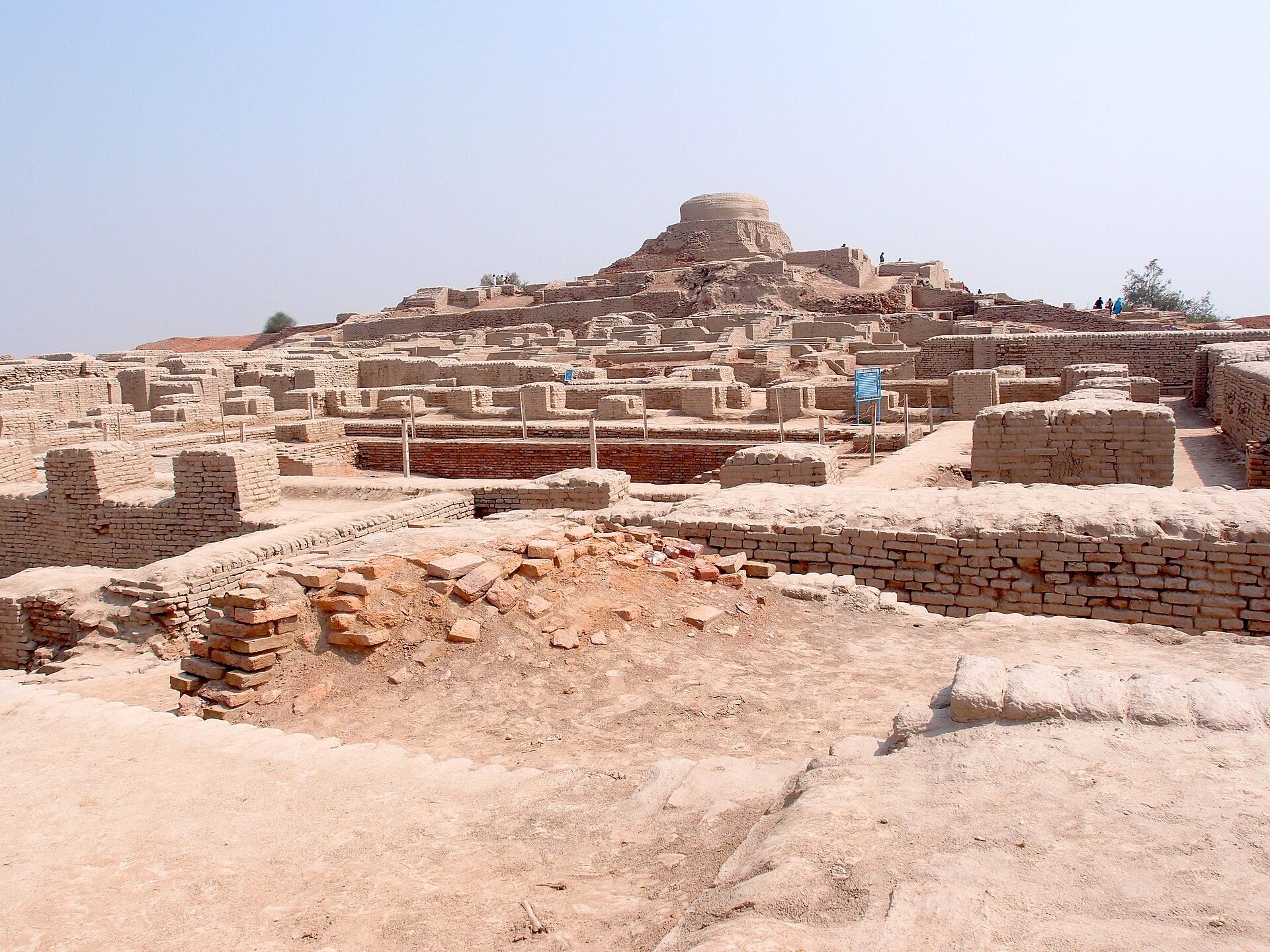
Mohenjo-daro occupied a floodplain setting on a raised ridge near the lower Indus. The excavated and estimated occupied area is variously placed at about 240–300 hectares, with site descriptions giving approximately 250 hectares. The city was divided into an elevated Citadel and a Lower City. Its streets followed a broad rectangular grid, with major routes generally running north–south and east–west and smaller lanes crossing them at approximately right angles.
The Citadel and public architecture
The Citadel occupied a large artificial mud-brick platform, approximately 9–12 metres high according to different measurements. Its lower levels contain earlier occupation, while the upper platform incorporated soil, brick rubble, and construction intended partly to raise the city above flood deposits. Public buildings, halls, residences, wells, elevated platforms, and defensive structures occupied this raised sector. Mud-brick walls and towers on the western and southern sides formed part of its defensive works, and a former passage between two towers was later blocked and replaced by a wall.
The Great Bath
The Great Bath is a rectangular brick-built pool about 12 metres long, 7 metres wide, and 2.4 metres deep. Brick stairways descend into it from the north and south. Tightly laid bricks, gypsum mortar, and a thick coating of bitumen, a naturally occurring waterproofing material, protected the floor and walls from leakage. A covered drainage channel stood at the southwestern corner.
A corridor, small rooms, and a verandah surrounded the pool. A nearby room contained a well that may have supplied water. Eight smaller bathing rooms were arranged in two facing rows. Each had thick walls and brick stairs, and their construction may have supported an upper storey, although the arrangement and function of these rooms remain uncertain.
The building known as the Great Granary
West of the Great Bath stood a large building traditionally called the Great Granary. Excavation in 1950 followed the removal of a later structure interpreted as a heated bath or hypocaust, a system that circulated heated air beneath a floor or through wall cavities. The underlying building measured about 46 by 23 metres and contained 27 divisions, wooden elements, and sub-floor air passages.
The granary interpretation remains disputed, and the building may instead have been a large public hall or a structure of uncertain function. A broad stairway about 6.7 metres wide led south towards the highest level of the Citadel, with wells near the stairway and among adjacent walls.
Other institutional buildings
A long building northeast of the Great Bath measured approximately 70 by 24 metres. It contained a central courtyard, three verandahs, and rooms arranged in a barracks-like plan. It was once called a college and has also been interpreted as a possible institutional or religious building, but its function is unresolved.
Another communal building south of the Great Bath and this building began as a square hall about 27 metres on each side. Brick seating was arranged in rows between five passageways, producing approximately 100 seats. The building was later altered. A large L-shaped hall may have served as an inn or lodging place for pilgrims. Brick columns outside its walls probably supported a verandah, while altered entrances, an underground ceramic drainage pipe, and a flush toilet formed part of its later arrangement.
A very large residential or palatial building measured about 76 metres from east to west. Its exterior walls were between 1.1 and 2.1 metres thick. Two large courtyards were linked by a corridor, and the building also contained an entrance, four stairways, two wells, and a circular oven. Another building, about 26.5 by 19.7 metres, had rooms opening onto an internal courtyard or the street. Five brick-built conical pits in a large outer room may have held metal vessels or supported restaurant-like activity or dyeing.
Buildings associated with ritual interpretations
A communal building about 16 by 12 metres had walls approximately 1.2 metres thick, a large southern entrance approached by two stairways, and a brick circle about 1.2 metres across in its courtyard. The circle may have surrounded a sacred tree, leading to a tentative interpretation as a tree shrine. Three fragments of a seated limestone figure were found nearby. When joined, the figure would have been about 42 centimetres high.
The seated figure has a beard, shaven moustache, tied hair, a narrow braid or headband around the head, and asymmetrically positioned hands. Its eyes probably contained inlays that have since been lost. The original position of the figure is uncertain, although its head was found near the circular enclosure.
Another building tentatively interpreted as a temple had exterior walls about 1.4 metres thick, surviving to roughly 2.4–3 metres high. It contained a central courtyard, two smaller courtyards, a southern well, and brick platforms whose function is unknown. A northwestern building contained two facing rows of sixteen small rooms. Each room had a larger inner chamber, drainage holes, and a water installation. The inner rooms may have been sleeping spaces, and the building has been interpreted as barracks, possibly for enslaved workers, although that identification is uncertain.
The Lower City
The Lower City contained residential blocks, workshops, streets, wells, bathing rooms, and covered drains. Houses varied greatly in size. Some exceeded 200 square metres and contained about 20 rooms, while many covered approximately 50–150 square metres. They commonly centred on internal courtyards and opened onto side lanes rather than major streets. Some had two or possibly three storeys, brick staircases, private wells, bathing rooms, storage spaces, verandahs, and underground drainage.
One well-preserved house had a five-foot-wide entrance lane leading to a gateway and vestibule. It contained a small guard or servant’s room, a well room, a courtyard, a paved bathroom, underground ceramic pipes, a staircase, and wall niches that may have held household figurines. Domestic sanitation included paved bathrooms, soakage pits, and flush or pour-flush toilets. Household wastewater passed through smaller channels into covered street drains.
More than 700 wells have been identified. They included private and public wells, as well as wells incorporated into or placed near major buildings. Most were circular and built with wedge-shaped bricks, although some were oval. As streets and floors rose during rebuilding, additional brick courses were added, leaving some excavated wells standing high above earlier street levels.
Covered brick drains ran along major streets and many smaller lanes. They received wastewater from houses through subsidiary channels and included access points for cleaning. A principal Lower City street was about 9.5 metres wide and ran north–south. Its surface incorporated brick fragments and mortar, possibly to support traffic, although clear wheel tracks have not been found.
Construction and craft areas
Buildings were mainly made from fired bricks laid with mortar. Sun-dried mud brick and wooden upper structures were also used. Walls commonly alternated courses of bricks laid lengthwise and crosswise. Timber played an important part in roofs, upper structures, platforms, and some major buildings, although most wooden elements have disappeared.
Workshops produced pottery, coloured materials, metal objects, beads, and shell goods. A shell-working zone occupied the northeastern part of the site. Furnaces appear to have been used mainly for copperworking and metal melting rather than iron smelting. The city also yielded copper and bronze figurines, bowls, tools, weapons, carts, ornaments, and tablets. Some objects demonstrate casting by the lost-wax technique, in which a wax model is moulded, melted out, and replaced by molten metal.
Pottery was generally wheel-made, although some vessels were handmade. Forms included painted bowls, pedestal dishes, jars, bread containers, strainers, and perforated vessels. Decoration featured geometric designs, peacocks, fish, deer, birds, plants, pipal trees, and human scenes. Some vessels had polychrome painting, slip or glaze-like coatings, and possible workshop or ownership marks.
Seals, figures, and other finds
More than 1,200 seals appear in one inventory, along with many additional seals and fragments. Usually made from steatite or related materials, these small objects were used to impress images or signs onto clay or another surface. Their imagery includes bulls, rhinoceroses, elephants, tigers, crocodiles, composite animals, trees, and human or divine-looking figures, often accompanied by short Indus signs.
The seal known as Pashupati shows a cross-legged, possibly ithyphallic figure surrounded by animals. It has been interpreted as a yogic figure, a three-headed proto-Shiva, or a “Lord of Animals,” but none of these identifications is certain. The Indus script appears on seals, pottery, tablets, and other objects. More than 5,000 inscriptions or inscribed examples are known across the wider civilisation, but the texts remain undeciphered and are generally very short.
The figure called the Priest-King is a seated soapstone sculpture about 17.5 centimetres high, found in 1927 in a building with ornamental brickwork and a wall niche. It depicts a bearded man with pierced earlobes, a head fillet, an armband, and a cloak decorated with drilled trefoil and circular motifs bearing traces of red pigment. “Priest-King” is a conventional archaeological nickname rather than proof of the figure’s identity or status.
The bronze Dancing Girl is about 10.5 centimetres high and was found in the HR area in 1926, buried roughly 1.9 metres below the surface of a house. The young, largely nude figure places one hand on her hip, while the other may hold a bowl. Her left arm is covered with bangles. The original is held in the National Museum in New Delhi.
Stone, terracotta, copper, and bronze figurines represented seated figures, bearded heads, female figures with elaborate headdresses and necklaces, bulls, buffaloes, elephants, rhinoceroses, monkeys, dogs, horses, sheep, and composite creatures. Many were handmade and painted red or polished. Several seated figures may have had religious significance, but their identities and functions remain uncertain.
Beads and jewellery were made from gold, silver, copper, bronze, steatite, shell, clay, jasper, carnelian, lapis lazuli, and other stones. Craftspeople used sawing, cutting, grinding, drilling, polishing, chemical colouring, and gold plating over copper. Terracotta toys included carts, bullock carts, animals, dolls, bird-shaped whistles, rattles, cages, gaming pieces, and dice. Some carts and animals had movable parts.
Standardised stone weights formed proportional series including 1, 2, 4, 8, 16, 32, 64, 160, 200, 320, and 640. The unit identified as 16 weighed approximately 13.64 grams. A shell measuring instrument and another excavated ruler provide evidence for carefully measured units. Together with the streets, wells, drains, public buildings, and flood-control works, these objects show the highly organised material culture of Mohenjo-daro.