Adulis: Port and Emporium of the Kingdom of Aksum
Site at a Glance
- Rating
- 4.8
- Popularity
- Very Low
- Country
- Eritrea
- Primary era
- Medieval
- Eras represented
- Medieval
- Civilizations
- Aksumite
- Site type
- City
On this page19 sections
History
Adulis is an ancient settlement on the Red Sea coast of Eritrea, near modern Zula in the Gulf of Zula. Its earliest clearly attested phase belongs to the Ptolemaic era, and it later became the principal port associated with the Kingdom of Aksum, a major state in the northern Horn of Africa that controlled or influenced Red Sea trade. The settlement developed as an emporium, an organized commercial center where goods from different regions were exchanged and redistributed.
Early settlement and the Ptolemaic period
Archaeological evidence places a late prehistoric settlement beneath the later city, dating from the middle of the second to the early first millennium BCE. Adulis may have been the locality called Wddt in Egyptian geographical records of the Eighteenth Dynasty, conventionally dated to around 1450 BCE, although that identification remains uncertain. During the first millennium BCE, the settlement belonged to a wider cultural zone extending across the Red Sea. Greek ships may have reached it as early as the seventh century BCE.
The possible presence of Sabaean agricultural communities, associated with the ancient South Arabian kingdom of Saba, remains a hypothesis. Adulis may also have been connected with the earlier polity of D’mt, but its relationship to that state and the possibility that it once formed the center of an independent kingdom remain debated. The city’s earliest clearly attested historical setting is linked with Ptolemaic Egypt, whose Greek-speaking dynasty ruled Egypt from the late fourth century to 30 BCE and maintained commercial interests around the Red Sea.
A Red Sea commercial center
Adulis served as a major entrepôt for ivory, animal hides, precious materials, slaves, and other products from the interior. Its maritime connections extended through the Red Sea to eastern Africa, southern Arabia, the eastern Mediterranean, and India. Later routes linked Aksum with the Nile Valley and the Mediterranean, while Roman merchants used the port during the second and third centuries CE.
Pliny the Elder provided the earliest surviving European literary reference to Adulis in the first century CE. He incorrectly interpreted the name as indicating a foundation by escaped Egyptian slaves and described the city as a principal market for the Troglodytes and the peoples of Aethiopia. The Periplus of the Erythraean Sea, an ancient Greek sailing and trade guide for the Red Sea, Arabian coast, and western Indian Ocean, also presented Adulis as a commercial center for goods exported from the interior.
Ptolemy’s second-century account may distinguish the Adulitae from the Aksumites, possibly treating them as an independent community. Later evidence places Adulis within the Aksumite kingdom by at least the third century, although the date and circumstances of its incorporation remain uncertain. Under Aksumite influence, the city helped the kingdom become the dominant power in the Red Sea, maintaining commercial relationships with India, southern Arabia, and the Roman and Byzantine empires.
Adulis and Aksumite expansion
Adulis had a military as well as commercial importance. Cosmas Indicopleustes visited the city around 520 CE, during the reign of the Aksumite king Kaleb, also known as Ella Asbeha. He recorded two inscriptions associated with Adulis. One described the victories of Ptolemy III Euergetes and his use of war elephants captured in the region. The other, known as the Monumentum Adulitanum, celebrated the campaigns of an Aksumite king in Arabia and northern Ethiopia. The king is unidentified, although he has been proposed as Sembrouthes or another early Aksumite ruler.
During Kaleb’s invasion of the Himyarite kingdom of Yusuf Asar Yathar, commonly known as Dhu Nuwas, around 520 CE, Adulis served as a base for the Aksumite campaign. The conflict brought Aksum into direct intervention in southern Arabia. Aksumite raids against Arabian ports continued later, with the occupation of Jeddah in 702 identified as the latest recorded raid.
Adulis also had an established Christian community by the sixth century. A fourth-century work traditionally attributed to Palladius of Galatia describes an Egyptian scholar’s journey to India to investigate Brahmanical philosophy, part of which was accompanied by Moses, the bishop of Adulis. Ecclesiastical lists likewise reflect an episcopal see there. Christianity was connected with Aksumite religious expansion along the western Red Sea coast, and one of the city’s churches was probably the seat of a bishop.
Decline and abandonment
Adulis’s later history is poorly documented. A traditional claim holds that an Arab expedition destroyed the city in 640 CE, but the evidence remains inconclusive. Excavations revealed fire and destruction deposits, while historical accounts indicate that the expedition may have failed. The city’s maritime importance and Aksum’s naval power nevertheless declined, and Adulis was probably abandoned around the eighth century.
Muslim writers later mentioned Adulis and the nearby Dahlak Archipelago as places of exile. Other evidence suggests that Aksum retained reduced access to the Red Sea after the city’s decline. The later history of the site also includes a brief colonial episode. In 1842, the Gulf of Adulis and the city were reportedly granted to French merchants, and Ethiopia recognized them in 1859 as part of French territory. The treaty was not implemented because Napoleon III’s government favored the port of Obock.
Exploration and archaeological investigation
A French mission led by Vignaud and Petit surveyed Adulis in 1840 and prepared an initial plan. In 1868, personnel associated with Robert Napier’s military campaign against Tewodros II of Ethiopia exposed several buildings, including the foundations of a church with Byzantine-like features.
The first scientific excavations began in 1906 under the supervision of Richard Sundström in the northern sector, followed by Roberto Paribeni’s work the next year. An expedition of the Ethiopian Institute of Archaeology, led by Francis Anfray, excavated at Adulis in 1961 and 1962. Those campaigns revealed a destruction layer and material strongly connected with the late Aksumite kingdom, encouraging the proposal that an Arab raid had destroyed the city in the mid-seventh century. That interpretation has since been partly rejected. A new archaeological program began in 2017 under the Pontifical Institute of Christian Archaeology and the Centre for Research on the Eastern Desert.
Following Eritrea’s independence, the National Museum of Eritrea requested the return of artifacts removed during earlier excavations from the Ethiopian government. The request had not been fulfilled.
Remains
The archaeological area extends for approximately 840 metres from end to end and about 430 metres across. It lies near the coast at roughly 25 metres above sea level, within a broad agricultural landscape close to modern Zula. Adulis occupied a sheltered position at the head of the Gulf of Zula, while the settlement itself was probably about 20 stades from the principal anchorage rather than directly on the shore.
Harbors and agricultural landscape
Maritime approaches
Several locations have been proposed for Adulis’s maritime anchorage. One was a simple landing place at the foot of the Galala Hills, possibly the island of Diodorus mentioned in the Periplus. Another was on the island of Orienê, now called Dese, whose lagoon could accommodate larger vessels at a later date. Two ancient circular watchtowers in the Galala Hills have been proposed as evidence for the harbor known as Gabaza.
Irrigation system
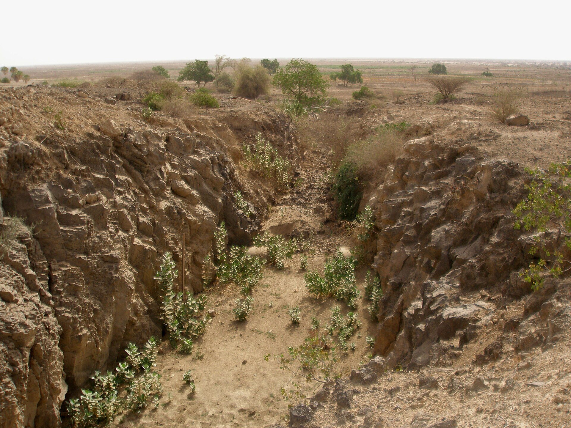
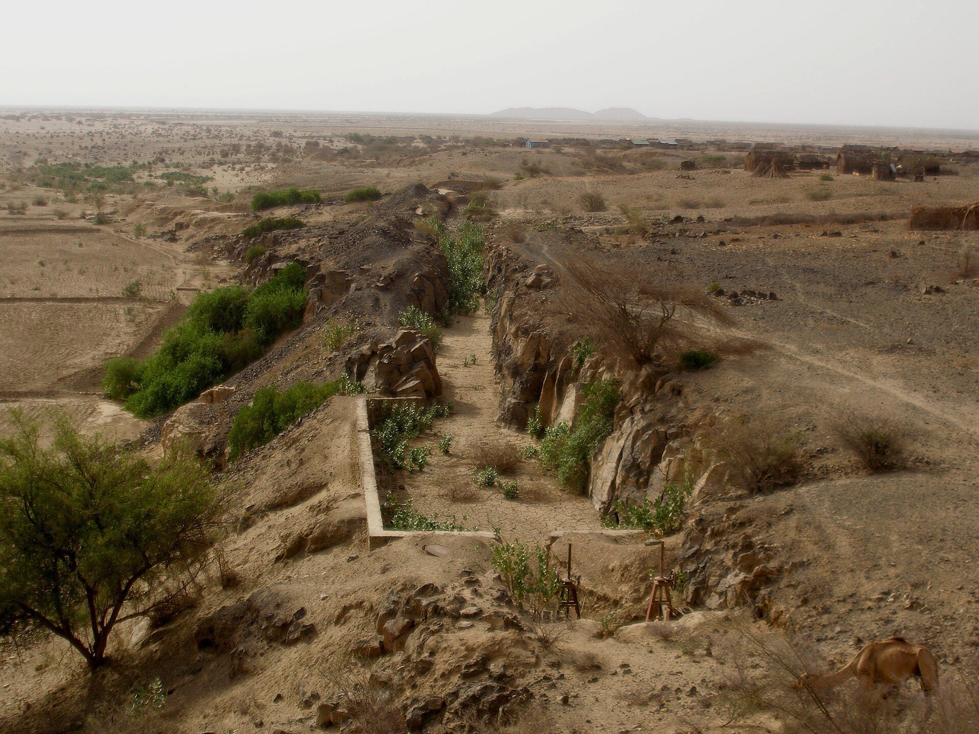
A substantial irrigation system supplied the settlement and its surrounding fields with water from monsoon runoff collected across a catchment of more than 2,000 square kilometres. Two original intakes stood on opposite sides of the valley and are now submerged beneath a modern dam. The system may belong to the Ptolemaic period or, possibly, to a Sabaean phase dating to the eighth or seventh centuries BCE.
The southern intake connected with a rock-cut canal up to 3 metres wide. Raised nearly 3 metres above the former riverbed, it ran for about 250 metres before making a sharp bend with an overflow. It then continued southeast along the relief before disappearing into the modern riverbed. The northern canal was 6 to 7 metres wide, followed a relatively straight course for about 200 metres, and ended at an oval distributor cut into the rock.
From the northern distributor, one branch ran northeast toward Afta while the main channel turned southeast. A further straight channel extended for about 500 metres to a three-way distributor. From there, water was directed north toward Adulis, east along an east-west branch, and southeast along a partly modified branch. The northern and southern oases may together have covered about 1,500 to 1,600 hectares at their greatest extent. Fields around and east of Adulis covered an estimated 6 square kilometres, with another 4 square kilometres toward Afta.
The southern main canal followed a winding course and divided into numerous west-east channels. The largest visible concentration of ancient fields lay along the eastern edge of the southern oasis, covering approximately 4.5 to 5 square kilometres. Sand conceals parts of the channels, so aerial and satellite imagery has helped reconstruct their courses.
Urban buildings
The northern structure
The northern sector contained a large building excavated by Sundström and called the “palace of Adulis.” Its identification as a palace reflects an excavation-era interpretation rather than a securely established function. The structure forms part of the city’s surviving urban evidence, but its original purpose remains uncertain.
Domestic buildings
Excavations uncovered numerous ordinary domestic buildings. Anfray’s campaigns exposed 22 rooms or spaces associated with small courtyards. The excavated group was relatively modest and was not considered representative of Aksumite architecture at its best.
Eastern church
The eastern church measures approximately 26 by 18 metres and was probably episcopal, meaning that it was associated with a bishop’s administrative center. Its central circle of eight pillars originally supported a dome about 8 metres in diameter. The building also contained a sacristy, a room used to prepare and store items for worship, and a baptistery, a space used for Christian baptism. The dome is described as the only known Aksumite example influenced by Byzantine architecture.
Central-eastern church
The central-eastern church is the largest of the partially excavated churches, measuring about 30 by 20 metres. It contained a nave and two aisles and passed through several construction phases. After it was abandoned, Islamic burials were inserted into the building during the seventh century, giving the structure a later funerary use.
Southern church
Roberto Paribeni called the southern church “Ara di Solis.” The building may incorporate a pagan structure dating from the fourth century beneath a church erected in the sixth century. Its remains therefore preserve evidence for a change in religious use during the period when Christianity became firmly established at Adulis.
Trade and religious finds
Pottery and coins
Large quantities of pottery have been recovered from the site, including vessels, oil lamps, ribbed amphorae from Gaza, and wine amphorae imported from the region of modern Aqaba. These materials reflect Adulis’s long-distance commercial connections across the Red Sea and eastern Mediterranean. Finds also include numerous Aksumite coins, among them three gold coins of Ethazas, as well as coins bearing Greek lettering.
Imported marble from the Byzantine Empire and Roman or Syrian pottery further illustrate the range of Adulis’s external contacts. Fragments of glass vessels from the lowest layers resemble examples from Egypt’s Eighteenth Dynasty, linking the earliest material at the site with wider connections along the Red Sea.
Christian objects and inscriptions
A specialized imported vessel known as a Menas flask came from Abu Mina in Egypt. It bears an engraved image of Saint Menas between two kneeling camels and may have been carried to Adulis by a pilgrim. The flask was intended to hold water from a spring near the saint’s tomb in Egypt.
The Monumentum Adulitanum was recorded from an inscribed throne that no longer survives. The inscriptions associated with Adulis preserve accounts of Ptolemy III Euergetes’ use of captured war elephants and an Aksumite king’s victories in Arabia and northern Ethiopia, connecting the archaeological site with the military and political history of the Red Sea.