Chandraketugarh: An Early Historic River Port and Urban Settlement in India
Site at a Glance
- Rating
- 4.2
- Popularity
- Medium
- Country
- India
- Primary era
- Classical
- External website
- Open
- Eras represented
- Iron Age, Classical, Medieval
- Civilizations
- Gupta
- Site type
- City
On this page19 sections
History
Chandraketugarh is an archaeological urban settlement at Berachampa in West Bengal, India, developed by communities of early historic South Asia beside the former Padma channel and the Bidyadhari River. Established approximately between 800 and 400 BC, it grew through the pre-Mauryan, Mauryan, Shunga, Kushan, Gupta, post-Gupta, and probably Pala periods before declining and being abandoned by the twelfth century. Its location on connected waterways made it a probable river port and commercial centre.
Origins and early urban development
The earliest cultural phase at Chandraketugarh predates Northern Black Polished Ware, a finely finished ceramic tradition associated with early urbanisation in northern and eastern South Asia. The settlement’s position beside the Padma and Bidyadhari gave it access to river routes leading toward the Ganges and the Bay of Bengal. The Bidyadhari later became separated from the Ganges, while silting and changes in the river courses weakened the communications that had supported the town’s economy.
A later phase, dated approximately from 400 to 100 BC, produced Northern Black Polished Ware, copper coins, seals, beads, jewellery, ivory and bone objects, and other evidence of craft production and exchange. The inhabitants worked in agriculture, boatbuilding, woodworking, ivory, beads, and terracotta, as well as in commerce. Hadipur has been associated with boats, shipbuilding, woodworking, and the production of Northern Black Polished Ware, while Gazitala has been linked with terracotta, bead, ivory, and other crafts.
Trade and the Kushan-period expansion
Chandraketugarh’s third cultural phase, broadly contemporary with the Kushan period, belongs to the first three centuries AD. The Kushans were a major Central and South Asian dynasty whose rule supported long-distance exchange across India, Central Asia, and the Roman-connected world. At Chandraketugarh, this phase produced Roman rouletted pottery, amphora fragments, amber ornaments and beads, mould-made terracottas, Kharosthi-inscribed seals, and seals showing grain ships.
The settlement maintained commercial connections with the Mediterranean world, especially Rome. Its position on routes linking Tamralipta with Kaushambi and Mathura has been interpreted as an important gateway for this trade. Chandraketugarh is also traditionally and archaeologically associated with Gangaridai, a powerful region or kingdom named in some Greek and Roman accounts of the lower Ganges. Its identification with the port called Gange in the writings of Ptolemy and the Periplus remains an interpretation rather than an established fact.
Gupta, post-Gupta, and later occupation
A fourth phase belongs to the Gupta and post-Gupta periods, followed by comparatively sparse evidence tentatively attributed to the Pala period. The wider settlement has also been described as continuing into the Pala-Sena period. Its fortified interior is generally interpreted as an area occupied by rulers and elites, while farmers, merchants, artisans, and other residents probably lived in surrounding unfortified areas. Early houses used clay, bamboo, and timber.
Local tradition connects the Khana-Mihir mound with Varahamihira, a sixth-century Indian astronomer, mathematician, and astrologer, and with Khana, his legendary daughter-in-law. The tradition describes the mound as their residence or working centre, but the association is not archaeologically established. Other local legends connect the name Chandraketugarh with a medieval king called Chandraketu and with the Devalaya area. These traditions explain the site’s traditional name but belong to a different period from the archaeological sequence.
Rediscovery and archaeological investigation
In 1906, local residents and the physician Taraknath Ghosh petitioned the Archaeological Survey of India, the Indian government institution responsible for archaeological research, conservation, and the protection of nationally important monuments, to inspect the site. Longhurst, superintendent of the Survey’s eastern branch, visited Chandraketugarh, followed by Nripendranath Basu in 1907 and Rakhaldas Banerji in 1909. Banerji was the first to offer a systematic interpretation of the settlement’s antiquity and importance.
The Asutosh Museum of Indian Art, established under the University of Calcutta in 1937, began the first archaeological excavations at Chandraketugarh in 1957 with the encouragement of Kalidas Dutta. Kunja Bihari Goswami and his colleagues continued the work until 1967 to 1968, using vertical excavation and the Wheeler compartment method. Excavation revealed five occupation levels associated with the pre-Mauryan to Gupta periods. Work at the Khana-Mihir mound exposed seven cultural levels extending from the pre-Gupta period to the post-Pala period, while investigations also took place at Itakhola and Nungola.
The excavations transformed understanding of the settlement’s chronology, urban organisation, craft production, ritual life, agriculture, clothing, social roles, and long-distance trade. Chandraketu’s Fort is listed and maintained by the Archaeological Survey of India, and the site is a monument of national importance. Principal excavated artefacts are preserved in the Asutosh Museum and archaeological museums, while other finds are held in private collections in India and abroad.
Remains
Settlement, fortifications, and river landscape
Urban enclosure
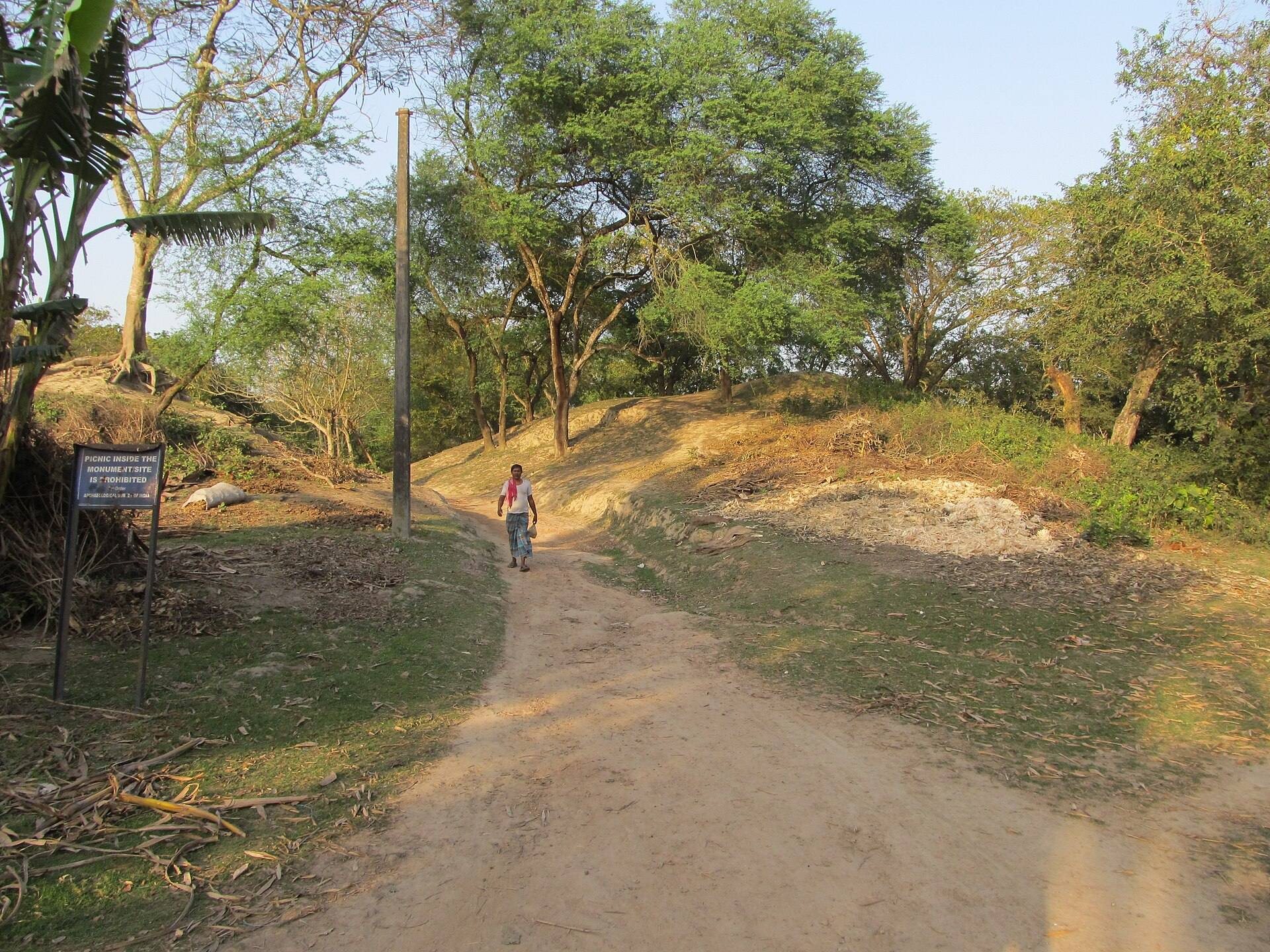
The wider archaeological remains extend across parts of Devalaya, Hadipur, Berachampa, Shanpukur, Jikra, and Itakhola, covering approximately 45 square kilometres. The principal settlement occupied an approximately square or rectangular area of about one square mile, enclosed by a massive earthen fortification reportedly accompanied by a rampart and moat. In 1922 to 1923, the enclosing walls were described as extending for about one mile and standing approximately 25 to 33 feet high.
Substantial brick embankments or defensive structures were found about 8 to 9 feet below the modern ground surface. They ran along an east to west slope, and comparable large embankments were exposed in the centres of ponds excavated at Gazitala in 2004. These structures may have originated in the Mauryan or earlier period and became especially important from the Shunga period, possibly in response to external attacks. A vacant area at the southwestern corner of the city wall is traditionally called the Lion Gate. Singher Ati and Hadipur lay outside the city wall.
River setting
The ancient settlement occupied several mounds on the southern bank of the former Padma channel. The river once flowed along the northern edge of the town, but silting has largely blocked its former course. A dry channel remains visible beside the road through Deganga, preserving part of the landscape that once supported Chandraketugarh’s river communications.
Temples and religious architecture
Khana-Mihir temple
The Khana-Mihir mound contained a large north-facing brick temple measuring approximately 63 by 63 feet. Verandas about 14 feet wide extended along its east, south, and west sides. On the northern side was a hall measuring approximately 45 by 45 feet, with walls about 4 feet thick. The exterior was decorated with terracotta plaques, represented by surviving empty settings in the brickwork.
The temple’s central sanctuary measured about 8 feet in length, 8 feet in width, and 23 feet in depth. A small square brick installation, approximately 2 feet 13 inches on each side, stood at its base. The structure is generally attributed to the Gupta period and later phases and appears to have been built three times, including a Gupta-period construction and a subsequent post-Gupta rebuilding. A lower fragment of a sandstone image of the sun god came from Gupta-period deposits. Fragments of terracotta zodiac panels have been connected tentatively with astronomical observation and the calculation of agricultural seasons.
Associated temples
A smaller temple stood near the principal Khana-Mihir temple. Another brick temple ruin, built in a Sarvatobhadra plan, rose more than 14 feet high. The excavated religious architecture, together with the zodiac panels and the traditional association of the mound with Varahamihira and Khana, has led to an interpretation of the area as a possible centre for an astronomer-priest group.
Later temple remains
Excavations in 1967 to 1968 produced a temple tentatively dated to the seventh or eighth century, along with Mauryan- and Kushan-period artefacts. The Khana-Mihir mound also yielded evidence for temple structures extending across Gupta and later phases, helping to connect the surviving architecture with the settlement’s long occupation.
Water management and underground construction
A deep underground refuse pit contained animal bones, pottery fragments, and pieces of wood. A well lined with arranged earthen elements lay approximately 10 to 12 cubits below ground and was interpreted as a source of purified drinking water. An underground sewage system was found in a field about half a mile from Berachampa on the road to Haroa. It consisted of connected terracotta pipes about 5 to 8 inches in diameter and 2 feet 7 inches long. The system lay about 13 feet below the surface and approximately 1 foot below the water table.
Construction used large sun-dried earthen blocks and substantial bricks for domestic and monumental buildings. Pottery from the settlement includes long-necked red ware, large rounded handleless bowls and cups, black, gold, and purple Northern Black Polished Ware, grey plain ware, stamped red ware, mould-made vessels, Roman rouletted ware, and black or dull-red amphora fragments.
Coins, inscriptions, and imported materials
Excavated objects include punch-marked copper coins, cast copper coins, silver and gold coins, seals and sealings, semi-precious stone beads, amber, glass, emerald, carnelian, ivory, bone, bronze, stone, and wooden objects. A punch-marked coin was made by striking symbols into prepared metal rather than casting a complete design in a mould. A total of 272 silver coins is reported from Chandraketugarh.
One silver coin shows two men and a woman, a tree within a raised enclosure, and a spider, while its reverse carries a peacock above a three-peaked mountain. Another rare silver coin depicts a single-deck seagoing vessel and a dolphin-shaped design. A gold coin of the Kushan ruler Huvishka shows the crowned ruler holding a ring, with an inscription identifying him as emperor; its reverse bears Nana, a Babylonian goddess. Kushan copper coins include square and round examples bearing mountain, chaitya, tree, elephant, and boat symbols. A chaitya is a Buddhist shrine or prayer hall.
Gold coins associated with Gupta rulers include an issue showing Chandragupta II as an archer with the goddess Lakshmi and another showing the marriage of Chandragupta I and the Licchavi princess Kumaradevi. The Kumaradevi coin was recovered during pond restoration at Hadipur, while the Chandragupta II coin was found at Singher Ati in 1969. A polished black chlorite pillar fragment recovered in 1911 was compared in finish with an Ashokan pillar. The same discovery included fragments of silver and copper vessels, a small yellow stone seal bearing the letter “ma” in a northern Indian script of the second or third century BC, terracotta fragments showing a sheaf of grain and an ankleted female foot, and two spindle whorls.
Chandraketugarh also produced Kharosthi- and Brahmi-inscribed pottery and seals. Kharosthi and Brahmi were ancient South Asian writing systems, with Kharosthi especially common in the northwest and Brahmi becoming an ancestor of many later scripts. One reported Brahmi inscription refers to the distance between Setubandha and the island of Tamraparni. Another inscribed object has been associated with the story of Vijayasinha’s marriage to Kuveni.
Terracotta art and daily life
Mould-made terracotta was the principal artistic medium from the Mauryan through Gupta periods. Mould use began during the Shunga period, while double-mould production became common under the Kushans. Figures and plaques represent an earth goddess, yakshas and yakshis, nagas, the sun god riding a chariot, Svaha riding a ram, royal couples with attendants, kinnara couples, dancers, musicians, riders, women, children, animals, toys, and household and decorative objects. Yakshas and yakshis are auspicious nature-associated male and female figures, while nagas are serpent-associated supernatural beings.
Other terracottas show a tiger-riding divine couple, possibly an early form of the folk tiger deity Dakshin Rai, as well as a Hellenistic-influenced Kushan male figure. Narrative plaques depict the abduction of Sita, stories from the Panchatantra, episodes involving Yashoda, Krishna, and cowherds, and a Buddhist image panel. A sandstone bodhisattva, a Buddhist figure associated with the salvation of other beings, is identified as one of the earliest Buddhist images known from Bengal. Jain imagery also came from the settlement.
Agriculture and occupations
Terracotta plaques depict rice harvesting with a crescent-shaped sickle, date-palm tapping, fishing, cooking, winnowing rice, transporting sheaves of grain, elephant riding, horse and chariot riding, music, processions, hunting, wrestling, elephant training, and craft or domestic work. One procession appears to show a harvest festival with an elephant, rice sheaves, musicians, and drummers.
Women and social activities
Women appear in varied social and occupational roles, including urban women, queens, entertainers, dancers, lovers, farmers’ wives, worshippers, mothers, shepherdesses, vendors, cooks, riders, charioteers, and festival organisers. Other plaques show women carrying water vessels, young women with parrots, bathing or preparing their appearance, and erotic couples. The ornaments on male and female figures imitate the work of goldsmiths, and numerous erotic figures were recovered.
Maritime connections and artistic exchange
Ship-decorated seals, boat coins, Roman rouletted pottery, amphora fragments, a Roman-style female bust, amber beads including one decorated with a scorpion, glass, emerald, and carnelian reflect Chandraketugarh’s maritime and overseas connections. Terracotta plaques share motifs and execution with material from Kaushambi and Ahichhatra, indicating artistic and cultural links with those settlements.
The site’s material also includes a stone grinding slab, a Mauryan-period stone ring with an interior frieze of nude mother-goddess figures, trees, and animals, and a small bronze image of Parvati. These objects, together with the coins, seals, imported ceramics, religious images, and occupational scenes, place Chandraketugarh within a network of production and exchange that connected the Ganges delta with wider South Asian and Mediterranean worlds.