Senegambian Stone Circles: A Megalithic Funerary and Ritual Landscape
Site at a Glance
- Rating
- 4.5
- Popularity
- Very Low
- Country
- Gambia
- Primary era
- Medieval
- Eras represented
- Medieval
- Civilizations
- Unclassified
- Site type
- Burial
- Remains
- Necropolis
On this page16 sections
History
The Senegambian stone circles are a megalithic funerary and ritual landscape extending across The Gambia and central Senegal. Built by communities whose identities remain debated, the monuments belong to a tradition generally dated from the third century BCE to the sixteenth century CE. The landscape covers roughly 30,000 square kilometres and includes more than 1,000 stone circles and tumuli, approximately 2,000 individual sites, and around 17,000 monuments.
A Long-Lived Mortuary Tradition
Burials appear to have preceded the erection of stones at many sites. The monuments were then used for further burials, commemoration, offerings, and other ritual practices. Their use therefore extended beyond individual interments, creating a sacred landscape that remained active for more than 1,500 years.
The monuments are sometimes grouped as the Gambian Wassu tradition and the Senegalese Sine-Saloum tradition. This division follows modern national boundaries rather than a demonstrated separation between cultural traditions. The four principal World Heritage areas are Wassu and Kerbatch in The Gambia, and Sine Ngayène and Wanar in Senegal.
The builders have not been securely identified. Proposed connections include ancestors of the Serer, Wolof, Jola, Bassari, Konyagui, and Mande-speaking peoples. Serer oral traditions attribute the monuments to the Soos, or Sose, although the ethnolinguistic identity of that group remains debated. Similarities with later Serer and Bassari funerary practices have contributed to these interpretations, but no attribution is established.
Communities and Changing Ritual Practice
The quarrying, shaping, and erection of stones weighing several tonnes required substantial labour and technical organization. At Sine Ngayène, nearby iron-smelting areas, stone quarries, and hundreds of contemporary houses point to prosperous communities living in small groups of two to five houses. These groups appear to have been connected while retaining a degree of independence. The cemeteries may also have been gathering places for wider communities.
Investigations at Sine Ngayène have proposed four successive mortuary cycles. Around AD 700–800, secondary burial, meaning the reburial of selected bones after an earlier burial or period of decomposition, took place in a large pit. A mound, an outer stone circle, and two frontal stones were then added. Between about AD 800 and 900, selected skulls and long bones were repeatedly reburied. From about AD 900 to 1000, an inner circle was constructed and activity shifted from selective burial toward offerings and broader ritual practices. A later phase, approximately AD 1235–1427, combined less frequent use with offerings, secondary burials, and possible redeposition of remains.
At Wanar, excavations distinguished simple burials in large pits sealed by mounds from deeper burials reached through narrow entrances. Brick and plaster fragments suggest that some graves may originally have been associated with funerary houses. A proposed sequence places the burial and mound first, the standing stones second, and the frontal stones third, although other sequences remain possible.
Research, Excavation, and Recognition
The Sine Ngayène Archaeological Project began in 2002 in the Petit-Bao-Bolong drainage area. Its work examined the relationship between monuments, settlements, quarries, iron production, and changing burial practices. Excavations in 2002 and 2003 investigated four monuments, two stone circles, and two graves. A separate excavation of the area designated SN-03 was conducted in 2003 by Augustin F. C. Holl and his team.
At Kerbatch, the Anglo-Gambian Stone Circles Expedition restored a distinctive bifid frontal stone in 1965 and excavated the double circle. Excavations by Evans and Paul Ozanne at Wassu in 1964 and 1965 uncovered burials that contributed to dating the monuments there to AD 927–1305. A small group of excavated objects, including an iron bracelet and two spearheads, was donated by the colonial administrator Richmond Palmer to the British Museum.
The Senegambian stone circles were inscribed on the UNESCO World Heritage List in 2006. UNESCO, the United Nations Educational, Scientific and Cultural Organization, recognized them under criteria concerning outstanding human creative achievement and rare evidence of a cultural tradition or civilization. The inscribed property covers 9.85 hectares and has a 110.05-hectare buffer zone.
Remains
Stone Circles and Frontal Markers
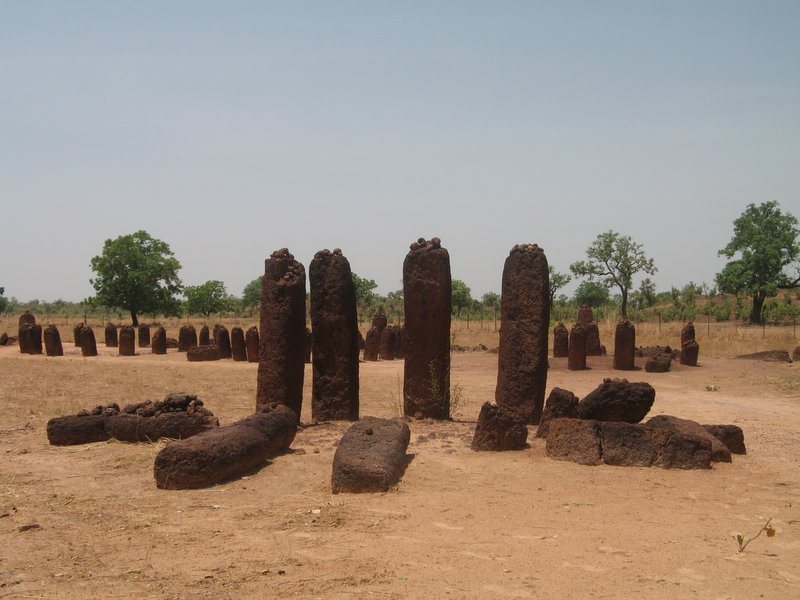
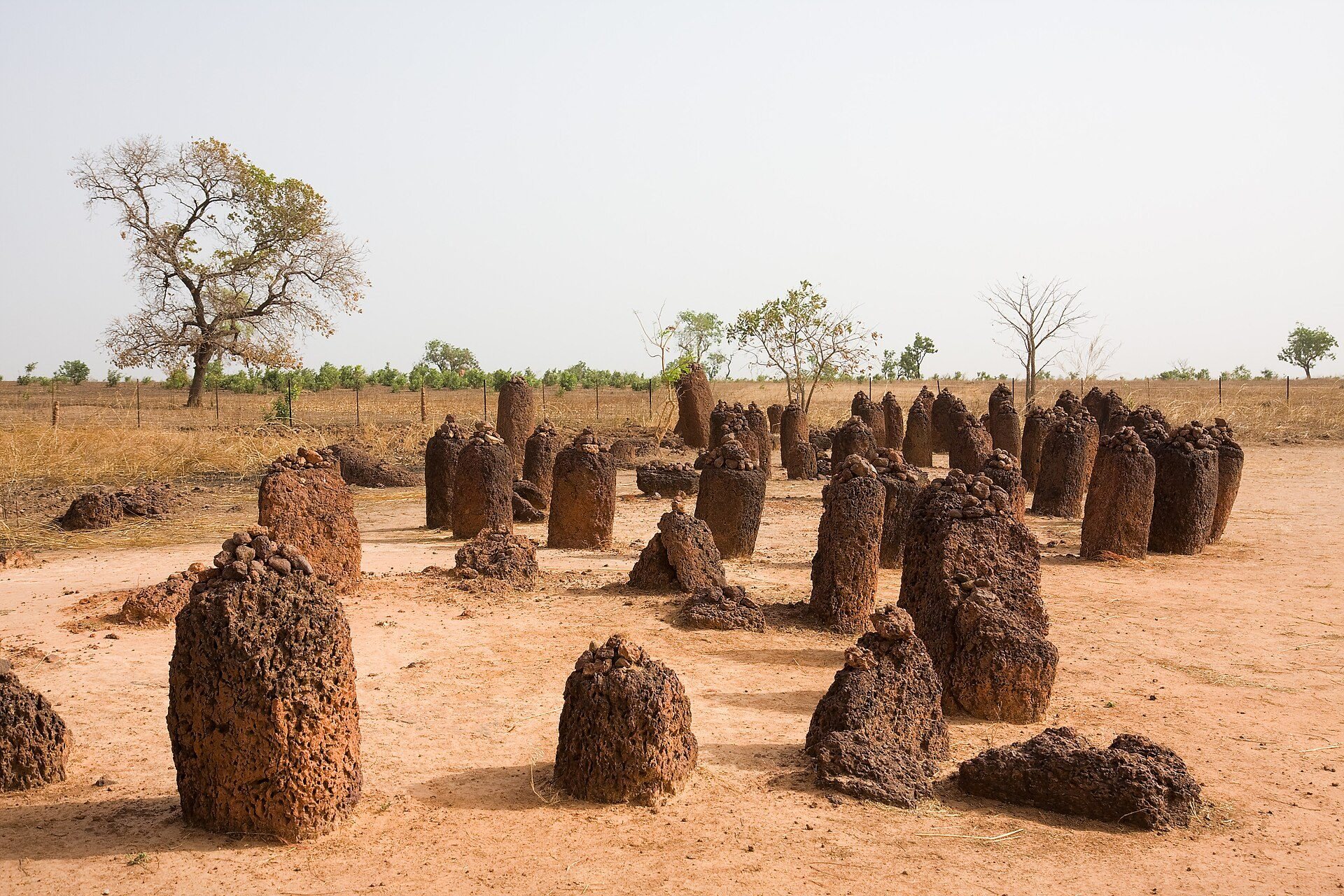
The monuments are formed mainly from upright laterite pillars. Laterite is an iron-rich tropical soil or rock that hardens into a durable building material. The blocks were extracted from quarries with iron tools and shaped into smooth cylindrical or polygonal forms. Stones average about 2 metres in height and 7 tonnes in weight, while individual examples range from approximately 1 to 2.5 metres high and can weigh as much as 10 tonnes.
Most circles contain between 10 and 24 stones. Other arrangements include double circles, isolated groups, and lines of stones outside the rings, usually on the eastern side. These detached markers are frontal stones. When two parallel rows are connected, they are known as lyre-stones. Small stones were traditionally placed on top of some monuments, although the meaning of that practice remains uncertain.
The largest reported concentration lies at Djalloumbéré near Wassu, where more than 1,000 stones form 52 circles. The Wassu area itself contains 11 circles and associated frontal stones, including a regional high point measuring 2.59 metres. Kerbatch contains nine circles and one double circle. Its distinctive V-shaped bifid stone, once part of a frontal line, broke in three places and fell before being restored in 1965.
Wanar and the Effects of Collapse
Wanar Stone Circles
Wanar contains 21 stone circles and one double circle. Approximately one third of all recorded Senegambian lyre-stones occur there. The monuments include tall, slender, generally cylindrical pillars alongside shorter, more compact trapezoidal stones.
Wanar Double Circle
The inner ring of Wanar’s double circle contains fallen monoliths that fan outward from the centre. Dry-stone remains around the monument suggest that these pillars may once have stood on a dry-stone cylinder filled with earth. Pressure from the fill may have contributed to the collapse of the inner ring. The outer stones fell in different directions, and the precise sequence of collapse remains interpretive.
The monument deteriorated gradually rather than collapsing in one event. Pottery was deposited after some dry-stone elements had fallen and before the monoliths collapsed, indicating that ritual or other activity continued after parts of the monument had been partly or completely abandoned.
Sine Ngayène Layout
Sine Ngayène is the largest of the four principal areas. It contains 52 stone circles, a double circle called Diallombere, and 1,102 carved stones. Hundreds of tumuli, or artificial burial mounds, once surrounded the complex, although many were levelled by erosion.
The cemetery has a Y-shaped central axis, with the double circle at the meeting point of its three branches. The circles are arranged broadly symmetrically around the centre. Circles 1–20 correspond spatially with circle 52, while circle 2 corresponds with circle 48. Lines connecting these groups intersect near the centre, just south of the double circle.
Frontal stones commonly stand on the eastern side of Sine Ngayène’s circles. At some monuments they leave a southern opening toward the central circle. The repeated preservation of northern portions of the circles, together with this arrangement, has been interpreted as relevant to the organization of funerary ritual.
Circle 27
Circle 27 is an unusual double circle in a central position within the cemetery. Its overall diameter is about 10 metres, its inner circle measures about 4 metres across, and its inner ring originally contained 15 pillars. The stones were generally spaced about 0.5–1 metre apart, although the inner ring was later reduced to 13 pillars.
Excavation divided the monument into six investigation areas, including northern trenches, a broad southern excavation, and a central trench measuring 2 by 2 metres. Deposits extended approximately 1.8–2 metres below the surface. Construction and use have been divided into three phases broadly spanning the seventh or eighth century to the fourteenth century.
The first phase contained three concentrations of secondary burials at depths of about 1.2–1.8 metres. They included approximately 20 skulls and about 100 long bones, including femora, arranged in a roughly circular but slightly elongated group. Four iron spearheads and a copper-alloy ring accompanied the bones. The remains were probably selected from earlier temporary burials and reburied collectively. The pit was roughly 2 metres wide and 2 metres deep, with skulls concentrated toward the north, south, and east. After the pit was levelled with alluvial soil and laterite blocks, the outer circle and two frontal stones were erected. The frontal stones created an eastern corridor or entrance area.
The second phase involved small pits containing selected long bones or teeth-bearing lower jaws at depths of about 0.6–1.2 metres. Some were marked by low mounds 30–50 centimetres high. The selection of femora, fibulae, tibiae, and mandibles indicates a change in mortuary treatment around the ninth or tenth century. The external arrangement remained broadly unchanged, with 18 stones forming the circle and two frontal stones.
During the third phase, deposits 0.2–0.6 metres below the surface contained fine bone fragments, probably produced by later disturbance or reworking. Between the eleventh and fourteenth centuries, the enclosed space changed substantially. A laterite slab with pottery was placed on the northern side, while small laterite blocks and pottery accumulated on the western side. The slab may have served as a surface for sacrifices, offerings, or vessels used in libation rituals, although its function is uncertain. These later features suggest that the monument developed from a burial place into a broader ritual space.
Circle 52
Circle 52 stands at the northeastern edge of the cemetery, about 120 metres from the nearest other structure. It measures approximately 3.5 metres in diameter and consists of 12 stones. Its frontal marker originally stood 1.9 metres high and 1.5 metres east of the circle. The marker later broke into three blocks and was probably destroyed and abandoned.
A 9-by-9-metre excavation area exposed about two thirds of the circle’s interior and reached approximately 1.8 metres below the surface. Two burials were found. The first lay 1.1–1.4 metres deep in the centre and represented a secondary burial containing at least three skulls and numerous long bones. Its associated objects included two iron spearheads, a short sword, two bracelets, a blue glass bead, and a carnelian bead.
The second burial lay about 0.8–0.9 metres below the surface. It contained numerous long bones and one skull, together with a scallop shell, a translucent blue bead, an iron spearhead, and an iron arrowhead. The arrowhead appeared to have entered the skull, raising the possibility of sacrifice, although that interpretation remains uncertain.
Circles 25, 28, and 32
Circle 25 began with a large primary burial pit. Two smaller pits were later cut into its northern and southern parts, and individuals were buried in flexed, extended, and seated flexed positions. A seated flexed burial places the body with the limbs bent and the upper body relatively upright. Iron, copper, and bronze bracelets, rings, and spearhead points accompanied some burials. A mound was formed within the original pit, followed by four further seated flexed burials. A circular stone ring and an outer line of marker pillars were then erected, probably with pottery beneath some pillars. Twenty-eight individuals were identified.
Circle 28 was built through successive burial episodes in a large primary pit. The pit was partly backfilled, reused, completely filled, and raised into a mound. A stone circle was then built around the mound, which was later covered with gravel. Fifty-six individuals were identified.
Circle 32 received two burial episodes at the bottom of its primary pit without separately cut small pits. A mound was formed inside the pit, followed by a third burial episode and complete backfilling. A circular stone ring and outer marker pillars were subsequently erected, probably with pottery beneath some markers. Ten individuals were identified.
Graves SN-03-T-01 and SN-03-T-02
Grave SN-03-T-01 lies near the centre of Sine Ngayène, several tens of metres from the double circle. Its mound is about 10.5 metres across and consists of yellowish-grey sandy clay. Excavation revealed a burial approximately 2 metres deep, with traces of burning. The earliest individual was buried on the back with the limbs extended, the upper body aligned east–west, and the face turned westward and slightly to the left.
The grave goods included an elaborate copper or copper-alloy neck ornament, a short sword probably carried in a sheath, eight iron spearheads measuring about 25–45 centimetres, an iron tube probably associated with a commander’s staff, a copper belt fitting or ring, and iron ankle bells. The assemblage has been interpreted as indicating a high-status warrior, although the individual’s precise identity and rank are not established.
SN-03-T-02 lies within 100 metres west of the double circle. Its mound is nearly 11 metres in diameter and consists of slightly raised yellowish-grey sandy clay. A poorly preserved individual lay 0.8–0.9 metres below the surface in a flexed side-burial position. The grave contained eight copper or copper-alloy bracelets on the left arm, another slender bracelet on the right arm, a copper or copper-alloy anklet, and an anklet made from fish vertebrae preserved by copper oxidation. The arrangement has led to the attractive but unproven interpretation that the burial belonged to a high-status woman whose grave complemented the nearby warrior burial.
SN-03 Ritual Installation
The area designated SN-03 lies between Circle 27 and SN-03-T-02. Excavation revealed a two-phase platform or ritual installation associated with two standing stones. The first phase, 50–70 centimetres below the surface, consisted of an oval laterite platform about 1.2 metres by 1 metre and 60 centimetres high, aligned toward the southwest. A large crushed jar lay to its south. An eastern hearth lined with stones and a laterite-lined, sand-filled hollow stood beside it.
The second phase lay 20–30 centimetres below the surface and contained three small stone-built platforms. One included a standing stone about 2.2 metres long. Another was an oval feature about 3.6 metres long and aligned southwest. The northern platform measured about 70 by 30 centimetres and was oriented northeast, with three pottery vessels around it. The installation was used for ritual activity, although its precise rites and the status of its users remain uncertain.
Burial Mounds and Associated Finds
The physical remains include burial mounds, stone markers, pottery, human bones, beads, metal weapons, bracelets, and other grave goods. At Sine Ngayène, one later secondary burial contained 70 bones, seven turquoise beads, and two copper rings. The combination may indicate long-distance exchange, although that interpretation is uncertain.
The monuments preserve different forms of burial practice. Some graves contain complete or partly articulated bodies, while others contain selected skulls, long bones, mandibles, or later redeposited fragments. These varied deposits, together with the changing arrangement of circles and offerings, show how the cemeteries could accommodate burial, remembrance, and ritual activity over successive generations.