Pont Ambroix: A Roman Bridge on the Via Domitia in France


Site at a Glance
- Rating
- 4.6
- Popularity
- Low
- Country
- France
- Primary era
- Classical
- External website
- Open
- Eras represented
- Classical, Medieval
- Civilizations
- Roman
- Site type
- Infrastructure
- Remains
- Bridge
On this page8 sections
History
Pont Ambroix, also called Pont d’Ambrussum, is a Roman bridge in France, built across the Vidourle at Ambrussum. Its construction dates either to the 1st century BC or to the 1st century AD, with the later date associated with the Julio-Claudian period, the first Roman imperial dynasty, which ruled from Augustus through Nero between 27 BC and AD 68.
A Roman crossing at Ambrussum
The bridge carried the Via Domitia, the principal Roman road of Narbonnaise. This route crossed southern Gaul and linked Italy with western Mediterranean routes. At Ambrussum, the bridge connected the road with the main street of the Gallo-Roman settlement below the nearby oppidum, a fortified settlement associated with Iron Age communities in western Europe. Ambrussum had begun as a Gaulish oppidum before developing into a Gallo-Roman settlement.
Decline and flood damage
Pont Ambroix remained in use until 1299 or into the late Middle Ages. Its importance declined as traffic patterns changed and the Via Domitia lost prominence. The community relocated to Lunel-Viel, which served north-south traffic more effectively. During the High Middle Ages, a chapel dedicated to Saint Mary was added to the bridge. The bridge was also reportedly partly demolished to divert traffic toward a newer bridge at Lunel, where a toll was charged, although this interpretation is not securely established.
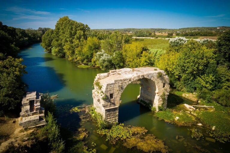
Anne de Rulman’s drawing of 1620 shows Pont Ambroix with four arches. A flood in 1745 destroyed one arch, leaving three visible. Major floods followed in 1812, 1891, 1907, and 1933. The flood of 1933 brought down another arch and left the single surviving arch.
Protection and archaeological work
Pont Ambroix has been protected as a French Historic Monument since 1840 and forms part of the Ambrussum archaeological site. In 1983, archaeologists led by J.-C. Bessac and J.-L. Fiches recovered stones from the collapsed sections and stacked them on the left bank for a possible reconstruction. The stones were not incorporated into a completed rebuilding of the bridge.
Remains
Surviving bridge structure
Pont Ambroix is an arched stone bridge that originally extended for approximately 180 metres across the Vidourle, between Gallargues-le-Montueux in the Gard to the east and Villetelle in the Hérault to the west. Eleven arches once carried the roadway. Only the fifth arch, standing in the middle of the river, survives. It has a span of 10 metres and is formed by a semicircular vault.
Construction and flood control
The bridge was built from large stone blocks measuring approximately 1.40 by 0.70 by 0.50 metres. The blocks were assembled without mortar and secured by bronze clamps sealed in lead. Stone corbels set into the sides of the vaults supported the temporary timber centering, the framework that held the arch in place until its masonry could support itself.
The bridge also had modest openings for floodwater and upstream cutwaters, projecting masonry that divided and reduced the force of flowing water against the piers. The restricted openings increased pressure from floodwater and contributed to the bridge’s eventual collapse. The surviving arch is therefore the remaining element of a largely ruined road crossing, while fallen stones from the other sections remain stacked on the left bank.
Historical images of the bridge
Several artworks and visual records preserve views of Pont Ambroix before further losses altered its appearance. Anne de Rulman’s 1620 drawing and an 1839 lithograph show the bridge when more than one arch survived. Gustave Courbet’s 1857 painting Le Pont d’Ambrussum depicts two arches, including the arch that collapsed in the flood of 1933.