Wari Archaeological Complex: Capital of a Pre-Inca State in Peru
Site at a Glance
- Rating
- 4.6
- Popularity
- Medium
- Country
- Peru
- Primary era
- Medieval
- External website
- Open
- Eras represented
- Iron Age, Classical, Medieval
- Civilizations
- Wari
- Site type
- City
On this page22 sections
History
Wari archaeological complex is the former capital of the Wari state in Carr Ayacucho-Quinua, Peru. The pre-Hispanic city developed during the Middle Horizon, an Andean period associated with the rise of large regional states, and flourished mainly between approximately AD 600 and 1000, within a wider Wari political history extending to about AD 1100. It grew from earlier village communities into a carefully planned urban centre whose functions included administration, politics, and religion.
Before the Wari city
The site had a long history before its urban expansion. The Churucana phase, an early settlement stage in the local sequence, dates from approximately 1200 to 200 BC. Later, Huarpa-period settlements occupied the Ayacucho Valley around the beginning of the first millennium AD. The Huarpa were an earlier regional culture whose communities initially consisted of farmers and herders. Their economic activity increasingly shifted toward manufacturing.
One interpretation places small Huarpa villages at the site toward the end of the Early Intermediate Period, the Andean period before the Middle Horizon. These settlements may have occupied the southwestern part of the later city, although their age and population remain under study. Wari is generally dated to around AD 400, and the settlement became prominent by about AD 550.
Urban expansion and political power
Wari developed from a village into a large urban centre divided according to a strict plan. During its greatest expansion, approximately AD 700–900, the city may have housed at least 40,000 inhabitants, while other estimates suggest about 70,000. State-directed construction repeatedly reorganized the settlement. Spaces were altered, restored, expanded, and sometimes cleared of earlier buildings as the city’s political and ceremonial needs changed.
The city eventually became the seat of regional political power. Its roads connected it with smaller centres, allowing people, goods, and ideas to circulate across the Wari political sphere. The settlement is described in one interpretation as an unusually large secular city and possibly the earliest city in the Andes. That interpretation distinguishes Wari from Tiwanaku, Cusco, and Chan Chan, which are characterized there as centres organized around religious or other specialized functions.
Wari’s religious and architectural development was strongly influenced by Tiwanaku, a highland Andean culture centred near Lake Titicaca in present-day Bolivia. One explanation proposes that Tiwanaku-related conquerors founded Wari. Another suggests that Wari forces captured people from Tiwanaku, who then introduced architectural traditions. These proposals remain interpretations rather than established conclusions.
Decline and abandonment
Wari’s political importance declined around AD 1000, when the city was abandoned at approximately the same time. The reason for this change is unknown. A military defeat has been considered unlikely in one interpretation. Parts of the settlement remained occupied during the decline, but the population became much smaller. By the final phase, only some courtyard groups beside entrances in the outer walls were inhabited.
Funerary evidence points to periods of crisis during the city’s history. Some burial chambers were looted and destroyed, possibly by emerging elites, while groups defeated by a dominant power may have removed some burial contents. Fills inside the chambers support these interpretations. The site may have contained mausoleums for approximately twelve Wari lords over roughly seven centuries of occupation, although this figure is an estimate.
Rediscovery and archaeological study
The soldier and chronicler Pedro Cieza de León gave the first description of the ruins in 1553. He called them “Vinaque,” after the principal river in the area, placed them near Huamanga, and distinguished their construction from Inca architecture. Julio C. Tello investigated the site and applied the name “Kollawa” to its ceramic style in 1942. Rafael Larco Hoyle began using the name Huari or Wari in 1948 and proposed that the complex was the place of origin of Wari culture.
John Rowe, Donald Collier, Gordon Willey, Wendell Bennett, Luis Lumbreras, William H. Isbell, Gordon F. McEwan, Christine Brewster-Wrary, Linda E. Spickard, and Enrique González Carré later contributed to the study of Wari. Excavation and conservation remain limited in relation to the complex’s size, and substantial areas are still buried. The complex is recognized as Cultural Heritage of the Nation of Peru. Its museum is administered by the Regional Directorate of Culture of Ayacucho and belongs to Peru’s National Museum System.
Remains
Wari lies on a sloping plain between the Pacaycasa and Taranayco ravines, about 22 kilometres northeast of modern Ayacucho, at an elevation of approximately 2,600–2,900 metres. The complex covers roughly 2,000 hectares, while its central urban core occupies about 400 hectares and contains the principal buildings. Plazas, streets, platforms, aqueducts, neighbourhood-like sectors, enclosing walls, and an extensive road network formed part of the planned settlement.
Buildings were made chiefly from stone and mud or mudbrick and were finished with fine plaster. Red-and-white painting was common, and white plaster or gypsum covered many buildings and floors. Some walls reached about 7 metres in height, while others exceeded 10 metres and were more than 1 metre thick. A large stone platform extended through the city as a long wall, possibly providing a route for construction workers and a means of moving building materials.
Urban plan and buildings
The city followed a strict grid. Square or rectangular blocks were divided into patio groups, planned residential or institutional units with long, narrow rooms arranged around open courtyards. Some rooms formed sequences of two or three, and some buildings may have had as many as three levels. Few doors linked one patio group to another, whereas numerous doors opened from courtyards into rooms and between rooms inside each group.
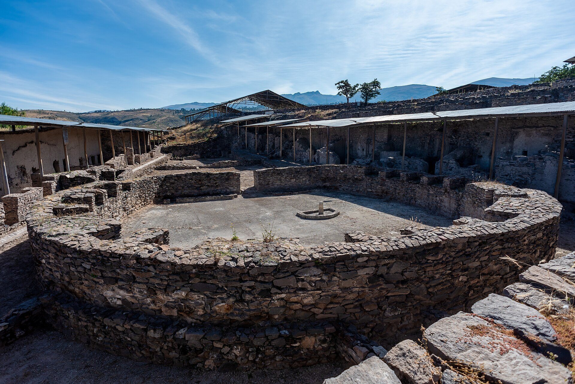
Residential compounds may have accommodated several nuclear families or larger multigenerational households. Other buildings had administrative or religious functions. D-shaped structures, with a curved side and a straight side, served sacred ceremonies, although the functions of several buildings remain uncertain. Later large cellular residential complexes were built at Moraduchayuq over structures influenced by Tiwanaku. In the final major building phase, central areas were cleared and levelled with fill, and trapezoidal buildings replaced earlier rectangular cellular structures.
Temples and ceremonial areas
Semi-subterranean temple
A semi-subterranean temple probably built between approximately AD 550 and 700 resembles Tiwanaku buildings of a similar form. Human and feline sculptures found at Wari may have belonged to this temple, although their original position is uncertain because they were removed from the city after its abandonment.
Vegachayoc Moqo
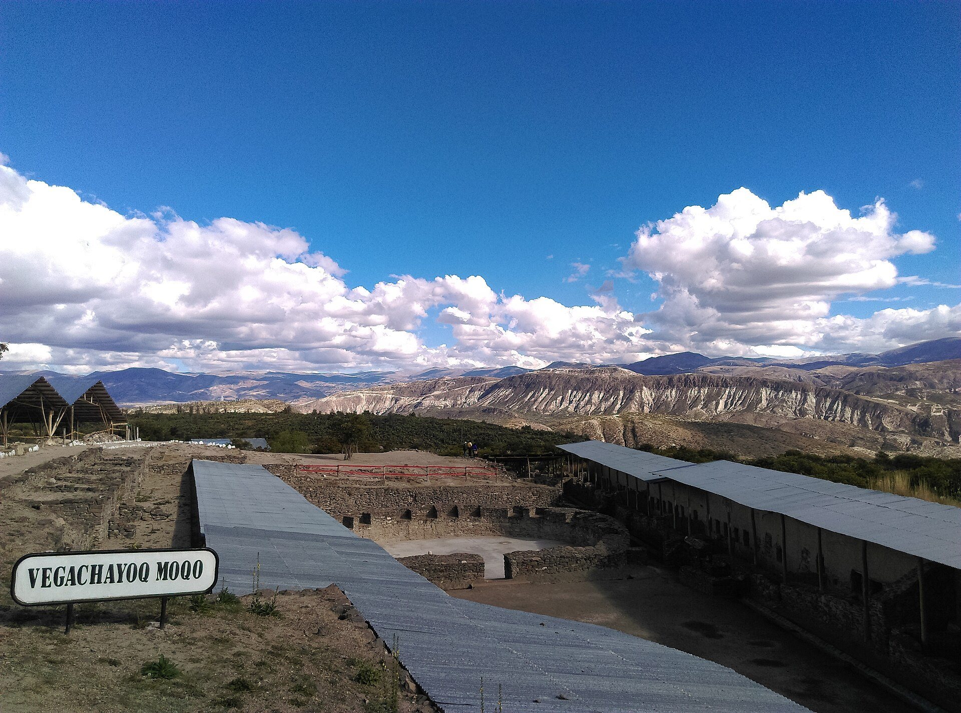
Vegachayoc Moqo was one of Wari’s principal ceremonial areas. An unusual architectural discovery made there in March 2015 cautiously raised the possibility that this sector had once been an earlier capital of the Huarpa culture.
Ushpa Qoto and Gálvezchayoq
Ushpa Qoto contained buildings near a plaza, three large parallel walls, semicircular structures, and underground rooms. At Gálvezchayoq, an intentionally excavated circular cavity measured approximately 11 metres across and 10 metres deep. Two carefully cut tunnels within it ran toward the north and south.
Funerary architecture
Monqachayoc
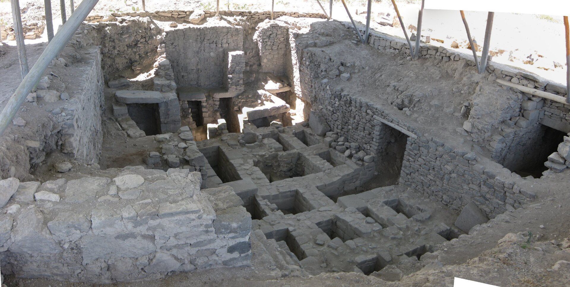
Monqachayoc contained underground galleries roofed with large single-piece stone blocks, walls faced with elongated slabs, mausoleums, a sunken courtyard, and burial pits. Stone tubes found in the sector probably carried water into the city. Its principal discovery was a finely cut-stone mausoleum about 8 metres below ground within a D-shaped structure. The compartments were arranged around a central space, while the excavated tombs in this sector had not survived intact.
Other funerary chambers at Monqachayoc were trapezoidal and covered by enormous stone slabs pierced by holes that opened directly into pits about 3 metres deep. The arrangement indicates different burial forms for elites and lower-ranking groups. Lower-ranking people were buried in simple pits cut into rock.
Funerary remains across the complex
An explored funerary area covered approximately 1,200 square metres, including about 400 square metres with stone-built chambers. Burials ranged from simple flexed adult interments with few grave goods to more elaborate stone-lined pits with lids or latches and offerings. Monumental tombs included several underground galleries and passageways. Many funerary contexts were affected by looting.
Enclosed sectors and specialised activity
Capillapata
Capillapata consisted of large double walls about 8–12 metres high and roughly 400 metres long. The walls were approximately 3 metres wide at the base and 0.8–1.2 metres wide at the top, forming large enclosed compounds or canchones, meaning walled areas.
Turquesayoc and La Casa de Blas
Turquesayoc contained many turquoise remains, including necklace beads and small sculptures. Their concentration suggests that workshops for working turquoise may have operated there. La Casa de Blas contained scattered stone artefacts, including projectile points, awls, and flints. Obsidian, flint, and guinea-pig pelvic bone were among the principal raw materials.
Canterón, Campanayoq, and Churucana
Canterón was probably used as a quarry. Campanayoq contained circular and trapezoidal enclosures in very poor condition, with only their foundations identifiable. Churucana contained trapezoidal and rectangular enclosures formed by walls similar to those at Capillapata.
Ushpa and Robles Moqo
Ushpa produced moulded human figures that may point to areas used for services, workshops, and storage. Robles Moqo contained ceramic sherds and broken stone artefacts. A Wari ceramic style was named after sherds from this sector, which were isolated by a local guide named Robles.
Petroglyphs and material remains
Trankaqasa contained sixteen petroglyphs carved into stone. Their designs were made by cutting grooves into flat surfaces and then lightly polishing them. The motifs include concentric lines, volutes, snakes, circles, and geometric figures.
Ceramics from Wari have smooth, decorated, or rough surfaces. Some vessels have faces on their necks, while others carry geometric designs on their bodies. Certain vessels stored agricultural produce, and others were used in making and consuming chicha, a fermented beverage made from agricultural products and used in Andean social, ritual, and political settings. Grinding stones suggest that chicha production may have taken place on a large scale.
Water management, agriculture, and roads
Agricultural terraces climbed the surrounding hillsides, increasing cultivable land where soils were not highly productive. Channels and drainage works, together with the terraces, supported the needs of the main city and secondary urban centres. The complex also preserves roads and routes linking Wari with smaller settlements, forming the physical infrastructure through which movement and exchange operated across the Wari political sphere.
Site museum
The site museum displays material recovered from excavations at Wari, including ceramics, clay objects, textiles, stone artefacts, monoliths, bone fragments, photographs, dioramas, a plan of the complex, and explanatory material about Wari culture.