Poverty Point: A Prehistoric Indigenous Earthwork Complex in Louisiana
Site at a Glance
- Popularity
- Very High
- Country
- United States
- Primary era
- Bronze Age
- Eras represented
- Bronze Age, Medieval
- Civilizations
- Unclassified
- Site type
- City
On this page22 sections
History
Poverty Point is a prehistoric Indigenous earthwork complex in Louisiana, United States, built by the people of the Poverty Point culture during the Late Archaic period, which preceded the Woodland period in eastern North America. Construction may have begun around 1800 BCE and continued until about 1200 BCE. The site became a major gathering and cultural center within a network of communities extending across the lower Mississippi region.
The Poverty Point culture and earthwork sequence
The Poverty Point culture’s central area covered about 1,800 square kilometres in what is now Louisiana. Settlements and camps extended beyond this core, while related communities and cultural influences reached into Mississippi and Arkansas, and as far as the Gulf Coast and Florida. The people who built the earthworks hunted, fished, and gathered food rather than relying on agriculture. They brought an estimated 70 tonnes of stone to the site, in some cases from sources more than 2,000 kilometres away. Access to these materials appears to have been shared within the community.
The purpose of Poverty Point remains open to interpretation. It may have served as a settled community, a place for gatherings and exchange, a ceremonial center, or several of these at once. Some interpretations connect its arrangement with cosmological ideas, harmony, or protection. The six ridges and six mounds have been read as a model of the world, with four directions, the sky above, and the earth below. The eastward opening of the ridges has also been associated with sunrise. Other interpretations emphasize geometric planning rather than an astronomical design.
The mounds were constructed in stages, and their sequence is not fully settled. Mound B is considered a likely early example. It may have been built quickly, over weeks or months, sometime between 1738 and 1522 BCE. Mound E probably followed at about the same time or soon afterward. Mound C is harder to place: people used its leveled building area before the mound was raised, and a date from beneath its base points to an early construction, although it may have come after B and E.
Mound A was probably begun after Mound C. Its construction is estimated to fall between 1311 and 1217 BCE and to have taken between 30 and 90 days. Vegetation on its building site had been burned between 1450 and 1250 BCE, before work on the mound. Mound F, identified in 2013, was built after about 1280 BCE and is considered the last mound added during the Archaic occupation. Mound D may be later still: part of it may have been built by the Coles Creek culture, a later prehistoric society of the region, perhaps nearly 2,000 years after Poverty Point’s main occupation, over an earlier ridge.
Motley Mound, about two kilometres north of the main earthworks, has an uncertain relationship to Poverty Point. Its cultural affiliation could not be reliably established, and it was not included in the 2014 World Heritage inscription. Lower Jackson Mound, about 2.9 kilometres south of the site center, dates to around 3900–3600 BCE, roughly 1,500 years before the main earthworks. It was not part of the Poverty Point complex, though it may have served as a landmark.
Changing lifeways and the plantation era
The end of the Poverty Point culture coincided with the transition from the Archaic to the Woodland period. The causes are uncertain. Proposed explanations include environmental changes that affected food supplies and the difficulty of maintaining the social and economic arrangements required for large-scale construction. The Tchefuncte culture, an early Woodland society of the lower Mississippi region, followed in the area. Local pottery production and new settlement and social patterns characterized this period; agriculture was introduced in the lower Mississippi region during the Woodland era.
The site’s modern name comes from Poverty Point, a nineteenth-century cotton plantation worked by enslaved people. Phillip Guier and his wife Sarah moved from Kentucky to northern Louisiana in 1832 and acquired land for the plantation, whose name was in use by 1851. Ploughing gradually lowered and partly leveled the earthworks. Sarah Guier and later members of her family were buried in Mound D, also known as Sarah’s Mound. A local settler noted Mound A and earth balls on the ground in the 1830s, but a regional survey in 1873 did not identify the earthworks as a constructed complex.
Archaeology and protection
Archaeologist Clarence B. Moore examined Poverty Point in the winter of 1911–12 and described its mounds and artefacts. In 1926, a Smithsonian Institution employee found fragments of a soapstone vessel at the site, but its importance was not yet widely recognized. Louisiana State Route 577 was later routed through the earthworks. In 1935, physician and amateur archaeologist Clarence Webb excavated a trench at the foot of a mound and recovered thousands of soapstone vessel fragments. He published the find in 1944 and later participated in further investigations.
Large-scale excavations began in the 1950s with support from the American Museum of Natural History. Using aerial photographs taken by the U.S. Army Corps of Engineers in the 1930s, archaeologist James A. Ford recognized that the ridges formed a geometric plan. Ford and Robert Neitzel investigated competing explanations for the layout and the relationship between ridges and mounds. Their work recovered Poverty Point Objects, shaped loess balls used in cooking, from cooking pits; experiments helped establish their use in earth ovens. Early radiocarbon dating, which estimates the age of once-living material, produced broad and uncertain results because the methods were inadequate.
Ford and Webb initially described Poverty Point as an agricultural settlement with maize as a staple. Ford also proposed connections with Mesoamerica, the region extending from central Mexico into parts of Central America, and the later Hopewell tradition of eastern North America. Subsequent research established that Poverty Point was not an agricultural society. An influential proposal by Jon Gibson that the culture was the continent’s first chiefdom, a political system with concentrated leadership and pronounced social ranking, was abandoned in the early 1980s.
Excavations and improved dating continued as Louisiana developed the site as a state historic site and museum. Research in the 1980s and 1990s identified many settlements and camps on Macon Ridge and in the surrounding region, clarifying Poverty Point’s connections with nearby communities. Work from 2001 onward improved the chronology of the mounds through sampling, excavation, and dating of heated materials. Geophysical surveys began in 2001, a detailed digital terrain model followed in 2002, and excavations of features identified by those surveys began in 2009.
Poverty Point became a National Historic Landmark in 1962, and Louisiana acquired it and designated it a state historic site in 1972. A 1988 act authorized national-monument designation, but Louisiana did not transfer the land to the federal government, so federal control did not follow. In 2014, UNESCO inscribed the site as the Monumental Earthworks of Poverty Point, recognizing its exceptional value as a large-scale hunter-gatherer complex. Trees were removed from the mounds in 2011–12 because storm-felled roots could damage them, and the displaced soil has been checked for artefacts. The World Heritage evaluation also called for stronger protection of the site and nearby land, including consideration of moving Route 577 and protecting neighboring agricultural and settlement areas.
Remains
Earthwork layout and construction
Ridges, plaza, and passageways
Poverty Point lies on Macon Ridge, a terrace bounded by Bayou Macon to the east and the Boeuf River to the west. Both waterways follow former Mississippi River channels; the river’s present course lies about 25 kilometres east. The terrace rises nearly 30 metres above sea level and 10–12 metres above the surrounding floodplain, a position that protected it from prehistoric flooding. Several metres of loess, a fine wind-deposited sediment, cover underlying clay and water-deposited materials. The protected property covers about 163 hectares, with the main earthworks occupying about 140 hectares. Evidence of occupation extends for more than five kilometres along Bayou Macon.
Six concentric, C-shaped ridges enclose a central plaza, with their ends reaching the eastern edge of the terrace and the opening facing east. The outer ridge has a radius of about 600 metres; the whole arrangement measures about 1.2 kilometres across at its widest and about 0.6 kilometres across at its innermost ring. Radial gaps, generally about 30 metres wide, divide the ridges into aisles and sectors. The ridges likely originally stood about 1.6–2 metres high. Today they rise between about 10 and 185 centimetres above the low areas between them, after roughly 150 years of ploughing. Their lens-shaped profiles have crests about 15–25 metres wide. The intervening low areas, or swales, are about 20–30 metres wide.
The innermost ridge and the terrace’s eastern edge enclose a plaza about 600 metres long from north to south and roughly 14 hectares in area. Builders leveled its uneven ground, filled gullies, and raised parts of its surface by as much as a metre. A shallow ramp with a gentle slope extends from the plaza and has been interpreted as access to water. Three more linear ridges or causeways connect features in the southern half of the complex. A southwest embankment crosses the ridges and a natural low area, and is approximately aligned toward the southernmost outer mound.
Earthmoving methods
The builders used mainly local earth, sometimes digging material from the spaces between ridges and leaving shallow borrow pits. They carried and piled the soil in baskets, then filled the spaces between the piles. Surviving clumps within the earthworks range from a few kilograms to more than 25 kilograms. Loess formed the principal fill, and clay may have covered it to limit erosion. Estimates of the total volume moved range from about 650,000 cubic metres to more than one million, with most estimates falling between 750,000 and one million cubic metres.
Mounds
Mound A
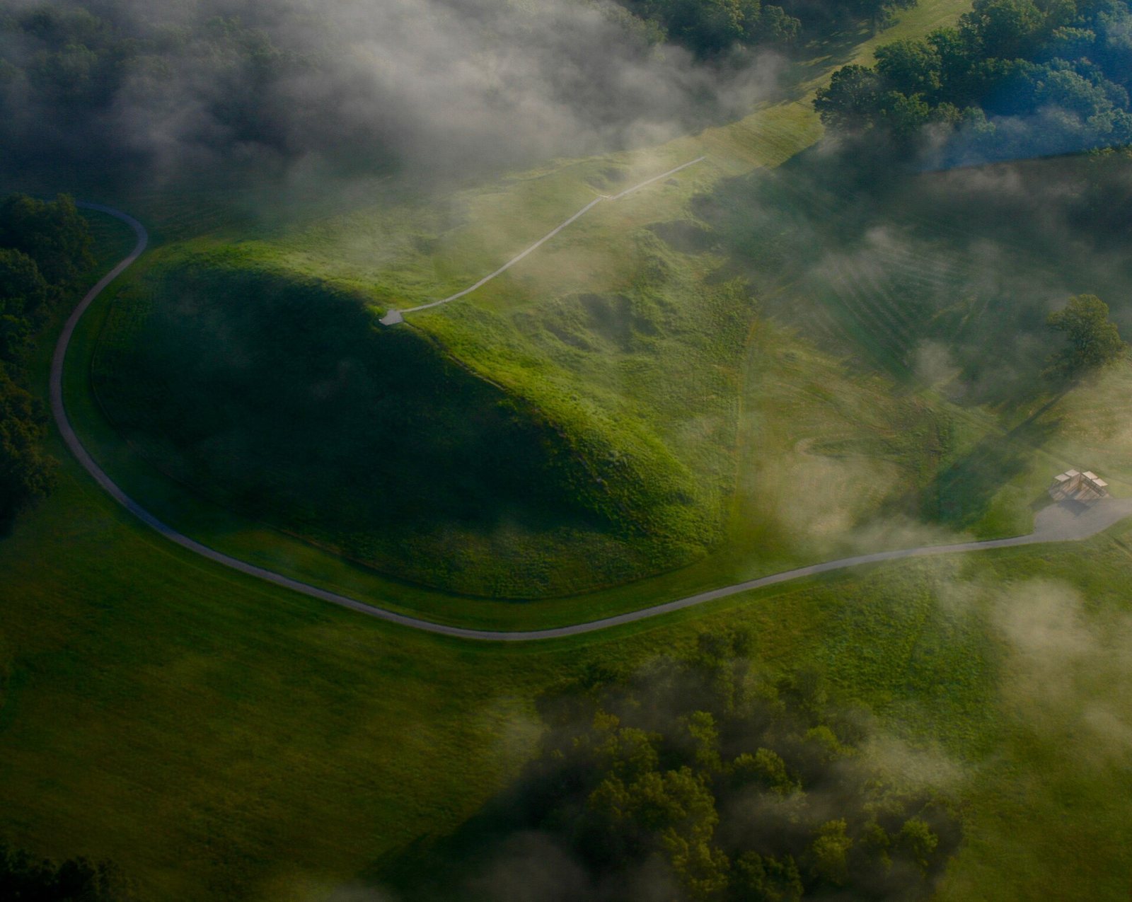
West of the ridges, Mound A has a roughly T-shaped plan. It stands about 22 metres high and measures approximately 215 by 200 metres at its base. Its form combines a raised platform on the east, a ramp rising westward to a cone, and a small platform at the top. Early excavators interpreted the shape as a bird, but that reading is speculative. Another interpretation views it as an earth island at the site’s cosmological center. Nearby shallow borrow pits mark places where fill was dug. The mound contains about 238,000 cubic metres of earth, making it the second-largest earthen mound by volume in eastern North America, after Monks Mound at Cahokia.
Mound B
Mound B lies northwest of the ridges, about 625 metres north of Mound A. Its approximately conical form is about 6.5 metres high and 55 metres across at the base. Charcoal, fire pits, and possible traces of posts occur at different levels within the fill. An upper layer preserves impressions left by woven baskets, and a final layer of silt-rich soil covered the mound.
Mound C
Mound C stands inside the plaza near the eastern edge of Macon Ridge. It is about two metres high and 80 metres long, with a present width of about 25 metres. Erosion has cut back its eastern side. Several thin layers of different soils, with small amounts of midden, or accumulated refuse, make up the mound; its upper layer creates a domed shape. A depression divides the mound and is thought to result from a nineteenth-century wagon road toward Floyd, Louisiana.
Mound D
Mound D is a rectangular earthwork built on one of the ridges. It is about 1.2 metres high and measures 30 by 40 metres at its base. A historic cemetery associated with the Poverty Point Plantation occupies its flat summit.
Mound E
Mound E, also called Ballcourt Mound, lies southwest of the ridges, about 405 metres south of Mound A. It is a rectangular mound with rounded corners, a flat summit, and a ramp extending from its northeastern corner. It is about four metres high and measures 110 by 90 metres at the base. Two shallow depressions on the summit inspired the name Ballcourt because they reminded some archaeologists of outdoor playing areas; they do not establish that ball games took place there. Excavations and soil cores indicate five stages of construction. Finds include a small amount of artefacts, among them pieces made from nonlocal stone such as novaculite, a fine-grained material suitable for tools.
Mound F
Mound F lies outside the ridges to the northeast. It is about 1.5 metres high and measures 24 by 30 metres at its base.
Motley Mound
About two kilometres north of the main earthworks, Motley Mound rises roughly 16 metres and has a base about 170 by 125 metres. Its form resembles Mound A in some respects. It may have been poorly preserved or left unfinished, but its cultural connection to Poverty Point remains uncertain.
Lower Jackson Mound
Lower Jackson Mound is a separate, older structure about 2.9 kilometres south of the site center. The conical mound stands roughly three metres high and measures about 35 metres across at its base. Baked loess blocks and Evans projectile points were found nearby. Its position forms a north–south line with Mounds E, A, and B.
Occupation traces and objects
Household activity and plaza features
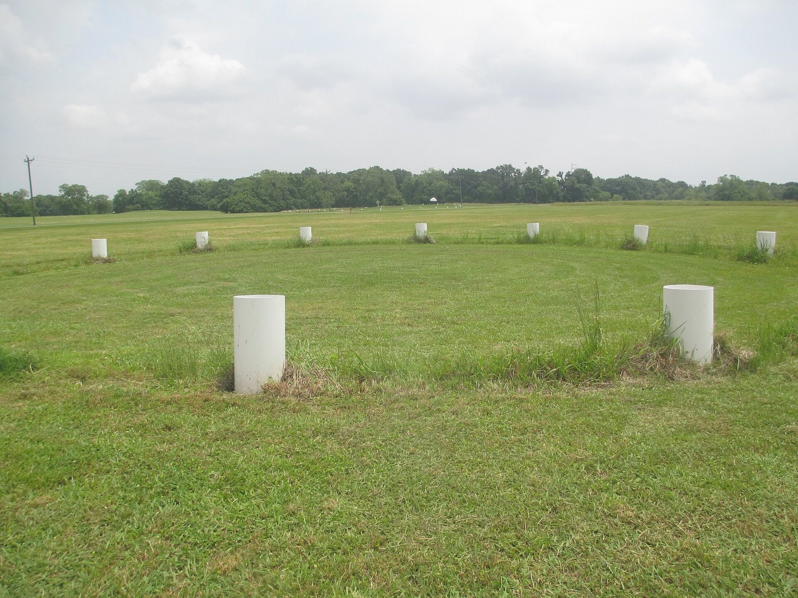
Ridges preserve traces of domestic activity, including postholes, hearths, and earth ovens. Excavation along Northwest Ridge 1 in 1980–82 revealed successive levels of household use, interpreted as possible evidence of longer-term residence. Ploughing and the limited size of many excavation areas make it difficult to reconstruct household layouts. Surveys and excavations in the plaza identified four circular arrangements of postholes, each about 25–63 metres in diameter. Some post pits were nearly three metres deep, consistent with rings of wooden posts. Dating of pit fill and overlying features places the circles within the period when the earthworks were being built. Large quantities of artefacts without visible wear from use were also recovered from the plaza.
Tools and stone materials
Hundreds of thousands of artefacts are incorporated mainly into ridge fill and, to a lesser extent, into the mounds. They include debris from preparing food and making tools, worn or discarded stone implements, beads, and occasional copper pendants. Tools include digging sticks with stone heads, hand tools for earthmoving, projectile points, scrapers, polished stone weights, and narrow blades called microblades. Microblades are especially characteristic of the central site. Their wear patterns have prompted the suggestion that they were fitted into wooden or bone handles and used to scrape edible roots, though that use remains uncertain. Teardrop-shaped weights, often found in household contexts, have been interpreted as either fishing-net weights or loom weights.
Stone came from sources spread across a wide area. Finds include galena, a lead-bearing mineral associated with the upper Mississippi region; high-quality flint from the Ohio River region; hornstone from the Tennessee River region; soapstone from southern Tennessee; and small amounts of copper. The copper’s origins were once placed as far away as the Great Lakes and Nova Scotia, while later analyses suggest that at least some may have come from the southern Appalachians.
Vessels, figures, and designs
Stone vessels, usually made of soapstone and sometimes sandstone, are rare, as is pottery. The pottery includes simple sherds made with different materials mixed into the clay, and whether it was produced locally or brought to the site remains disputed. Only a small proportion may have used local clay. Gourds may also have served as containers, cups, spoons, or floats for fishing nets.
Other finds include ceramic, stone, and copper pendants, along with small figures of animals and human forms. Small jasper figures interpreted as owls also occur at other Poverty Point culture sites, though their meaning is unknown. Incised designs on stone and pottery depict birds, turtles, other animals, and geometric patterns; some combine curved forms with geometric shapes. Small figures have been interpreted as fetishes or talismans, but that interpretation is uncertain.
Poverty Point Objects
Poverty Point Objects are shaped balls of loess, generally about 2.5–5 centimetres across and made in several forms. Heated in a fire and placed with food in earth ovens, they released heat gradually and helped control cooking temperature and time.