Merkit Fortress: A Mountain Ritual Site in Buryatia, Russia
Site at a Glance
- Popularity
- High
- Country
- Russia
- Primary era
- Bronze Age
- Eras represented
- Bronze Age, Iron Age
- Civilizations
- Unclassified
- Site type
- Religious
- Remains
- Sanctuary
On this page16 sections
History
Merkit Fortress is a mountain sanctuary on Orekhovaya Mountain in Buryatia, Russia, associated with ancient ritual activity and counted among the largest cult sites in Western Transbaikalia. Its stone constructions have been dated variously to the Bronze Age or the twelfth or thirteenth century, and their purpose remains debated.
Identification and competing interpretations
V. V. Popov identified the site in the 1920s after climbing the mountain with B. Togmitov; its first recorded mention dates to 1928. Popov used a Buryat and Mongolian name meaning “Yellow or Golden Platform” and described stone structures and burials. After his report appeared, the site received little attention until the late twentieth century.
Archaeologist A. V. Tivanenko visited the ridge with I. A. Batuev in 1988 and later popularized the name “Merkit Fortress,” mistakenly believing he had discovered it. He interpreted the site as a medieval stronghold of the Merkits, a people of medieval Mongolia, and suggested it might be the fortress of Tailakhan mentioned in The Secret History of the Mongols. Later, V. I. Tashak and Yu. E. Antonova argued that the small, exposed, waterless platforms could not have sheltered the large population Tivanenko proposed. They interpreted the stone works as ritual constructions rather than fortifications. Historian B. R. Zoriktuev likewise described the place as primarily a natural formation with traces of human activity.
Tashak and Antonova associated the sanctuary with the late Bronze Age, drawing a comparison with the nearby sanctuary of Ger-Shuluun. Other interpretations also place the works in the Bronze Age, perhaps more than 3,000 years ago, and suggest cultural similarities between their makers and the ancestors of Koreans. Tivanenko instead dated the fortress to the twelfth or thirteenth century. These differing proposals reflect continuing uncertainty about when the stone features were made and how they were used.
Archaeological research and finds
Detailed study began in 2012. Researchers mapped sections of the stone walls extending as far as 500 metres into the ridge slopes and excavated a test pit. A small quantity of thin pottery decorated with cord impressions came from the site, but it does not establish a precise date or cultural affiliation. Other finds include ornaments, iron knives and bronze objects. Tashak and Antonova interpreted the ornaments as offerings, consistent with their view of the site as a sanctuary.
Legends, discoveries and later pressures
Local legend says that the Merkits held Borte, Genghis Khan’s first wife, at the fortress. Genghis Khan, founder and first ruler of the Mongol Empire, is said to have attacked with 4,000 men and freed her. The tale says that men taller than a cart wheel were killed, while women and children were distributed among other tribes, bringing the Merkit people to an end. It links the couple’s reunion to a spring now associated with Genghis Khan. No direct evidence places him at the site. A 1952 manuscript by G. L. Lenkhoboev records a similar story and describes a Merkit palace resembling the fortress.
In 2010, schoolchildren found Tibetan Buddhist religious paintings in a cave. They were probably concealed there by Buddhist lamas in the 1930s or 1940s, during the destruction of local monasteries. After the children removed them, the paintings were returned to the site.
Treasure seeking has left dozens of pits around the mountain, with smaller pits from metal-detector searches on the platforms. Foot traffic has worn away moss and undergrowth, contributing to erosion and the risk of rockfalls and soil slips. Vehicles and piles of stones taken from burial areas have also caused damage. In 2021, mechanical damage affected 20 percent of the relict apricot trees beside the trail. Signs and barriers prohibiting vehicles had been installed by 2023.
Remains
Setting and overall form
The archaeological area occupies a mountain spur, its rocky outcrops and slopes on the southwestern spurs of the Tsagan-Daban range, at the mouth of the Tugnuay-Sukhara valley. It lies about five kilometres east of the Khilok River and 110 kilometres from Ulan-Ude. The area extends for more than 880 metres from south to north. Its east–west span is about 200 metres measured to the foot of the rocks, and up to 350 metres along the foot of the slopes. The lowest point is about 150 metres above the river and the highest more than 400 metres above it; the rise from the slope foot to the highest points exceeds 260 metres.
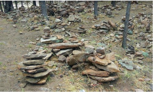
Natural landforms and built stone features form a single complex. Three walls consist of unworked rock fragments set upright and secured at their bases; three ramparts were made by piling unworked stone, and a single rock fragment stands vertically on a flat area. Natural features include three flat summit platforms, an erosion-cut groove, wind-shaped forms and ridges resembling banks and ditches. The ramparts have been interpreted as enclosing sacred areas and connecting rock outcrops.
Southern approach and first platform
First wall and Haylasyn graves
Near the southern foot of the spur, the first wall begins beside an enclosure around a prehistoric stone-covered burial mound, then curves west around the slope. It is about 305 metres long; Popov measured it as 865 paces. Its slabs reach about a metre in height. Once upright, they now lean to differing degrees. The wall initially lies 15 to 40 centimetres from the slope, with the gap widening to as much as 20 metres. Up to 15 graves once lay between wall and mountain. Most of their above-ground structures have been destroyed, leaving some supports for the covering slabs. The wall has been interpreted as dividing ordinary ground from sacred space.
Second wall, passage and summit
About 360 metres north of the graves, and 120 metres above them, the second wall stands beside a steep slope. Set four to five metres from the rock, it helps form a passage whose lower end faces west. The wall curves around the rock base and continues uphill to the north. The passage trail is about 50 metres long, and the wall can be traced for 34 metres, including stretches of isolated, tilted or fallen slabs and supporting stones. Its lower section is best preserved.
At the passage’s northern end, an erosion-formed groove about eight metres long leads to a flat rock summit. The summit’s western edge is a cliff about 40 metres high, with rockfall at its base; the cliff face continues north for about 150 metres. Steep drops bound the summit to the south and west, the groove opens to the east, and a steep slope covered with apricot trees lies to the north. Another rock rises 80 metres north of the groove, with a terrace-like surface to its west.
First platform rampart
A rampart begins just south of the groove’s exit and runs about 85 metres to the foot of the northern rock, following the eastern edge of the first platform and separating its flat surface from the slope. Tashak and Antonova interpreted it as marking a ceremonial sacred area. They also proposed possible solar alignments. At the groove’s midpoint, the winter-solstice sunset, when the Sun reaches its southernmost apparent position, appears to touch the summit of a mountain about 24 kilometres to the southwest before moving down its slope. Researchers have suggested that the enclosure’s western course may have marked this event. From the platform’s western part, the spring-equinox sunset, when day and night are nearly equal, appears along the centre of the trail; proposed sighting markers remain an interpretation.
Northern platforms and ramparts
Second platform
The second platform lies about 400 metres north of the first rampart’s northern end and 70 metres above the first platform. It projects west of the ridge slope and forms a shallow depression in the rock, filled with coarse gravel, small stones and sand beneath turf. Broad raised edges mark its western and northern sides; rock bounds it to the east, while the southern side is open with low edges. On its northeastern edge, a wall of upright slabs about three metres long runs almost due north. A line of stones bridges a gap in the rock forming the northern boundary.
Third platform and additional ramparts
The third platform and its rampart lie about 80 metres southeast of the second platform and 30 to 37 metres above it. The rampart, about 30 metres long, follows a ridge between two rocks and bounds the platform on the north and northeast. The platform opens to the south and southwest, sloping gently downwards in that direction. Near its centre, an elongated rock fragment stands supported by stones.
A further rampart, about 12 metres long, lies 15 metres southeast of the 30-metre rampart. It runs between rocks along the ridge and over natural outcrops; a low rock mass separates the two ramparts.
Caves and natural environment
Caves
Several caves occur within the area. One old cave on a mountain slope is now blocked with stones; local legend says a passage from it leads to a sacred place. An oval opening in a rock is associated in another legend with an arrow shot by Genghis Khan.
Vegetation and wildlife
Siberian apricot, Labrador tea and caragana grow on the mountain slopes, along with wolfberry, cloudberry and mountain onion. Depending on spring conditions, apricot trees flower for one or two weeks in early or late May. Their sour fruit generally does not ripen during the short summer. Wildlife in the area includes Pallas’s cats, Daurian hedgehogs, mountain martens and white-tailed eagles.