Ita Fort: A Medieval Fortified Complex in Itanagar
Site at a Glance
- Country
- India
- Primary era
- Medieval
- Eras represented
- Medieval
- Civilizations
- Unclassified
- Site type
- Military
- Remains
- Fort
On this page11 sections
History
The Chutia kingdom and the fort
Ita Fort is a medieval fortified complex in Itanagar, the capital of Arunachal Pradesh, India. It is generally dated to the 14th–15th centuries and tentatively attributed to the Chutia kingdom, a medieval regional polity associated with Assam and adjoining areas. The name means “Fort of Bricks,” from the Assamese word ita for brick, and also gave Itanagar its name. No inscription names the fort’s builders, so the attribution remains uncertain.
The fort has been associated with a Chutia tradition about King Gauri Narayan, who was said to have built hill-foot forts, large ponds, and temples after consolidating his kingdom. Similar builder’s marks at a ruined fort on the Buroi River and at Tamreswari Temple near Sadiya have been taken to suggest that Chutia fortifications extended west as far as Biswanath. Because Ita lies east of Buroi, it has been interpreted as part of the same chain. Land grants issued by Chutia kings place the plains to the fort’s south and southeast, including historic Habung in the Subansiri–Brahmaputra valley, within the kingdom during the 14th and 15th centuries.
Mayapur and legendary traditions
In 1941, D. N. Das, then a political officer in the former Balipara Frontier Tract, proposed that Ita Fort might be Mayapur, the capital of a legendary ruler called Ramachandra or Mayamatta. This identification is disputed. The Assamese chronicle Adi Charita, dated to 1664 and considered historically doubtful, instead places Ramachandra’s capital at Pratappura and connects him with the title Pratappuriya. Some scholars have located Pratappura near Biswanath, where an inscription on Uma-Tumani Island refers to a ruler as Pratapuradhikari. Another tradition places Pratappura at Ratnapura in Ratnapitha, a region generally situated between the Karoya and Sankosh rivers.
The Kamrupar Buranji places the Ramachandra story in a wider Kamarupa setting, describing Ramachandra as ruler of Kamarupa and Phengua as ruler of Kamata, and linking the tradition with Nilachal, Vaidyagarh, and Pratappura. Other accounts name Ramachandra’s son Arimatta, also called Sansanka, as ruler of lands corresponding to present-day Kamrup, Darrang, and Sonitpur. They give his capital as Baidargarh, or Betna, and say he conquered Kamata by killing its ruler, Kamateswar Phengua.
Scholars Dimbeswar Neog and Edward Gait questioned the historical reliability of Adi Charita, whose narratives draw chiefly on legend and popular tradition. The existence and chronology of Ramachandra and Arimatta lack contemporary support, and the traditions about them are late and divergent. The fort’s distance from the proposed locations of Pratappura, Biswanath, Kamarupa, and Kamata has also been cited as a reason to doubt a connection with the Arimatta line.
Remains
The enclosure adapts an irregular, elongated, partly semicircular plan to the hills of present-day Itanagar. It extends along slopes from south to north and covers more than one square kilometre. Brick ramparts defend its eastern and western flanks, while steep ridges and peaks form natural defenses to the north and south.
The fortified enclosure
Ramparts
The northern and southern ridges extend for more than a kilometre. The western rampart runs for about 1.5 kilometres and has two gates; the eastern rampart has one. The ramparts average about 11.5 metres in width, and their original height is estimated at about five metres. They were made from parallel brick walls, with the gap packed with earth and broken brick. Builders used mud mortar, along with iron clamps and nails. Brick and stone, chiefly sandstone, form the main construction materials, and the bricks vary in size, including some decorative examples. In surviving sections, foundation layers measure about 2.06 to 2.08 metres across and 1.4 metres high. The total volume of brickwork is estimated at 16,200 cubic metres.
Eastern and western gates
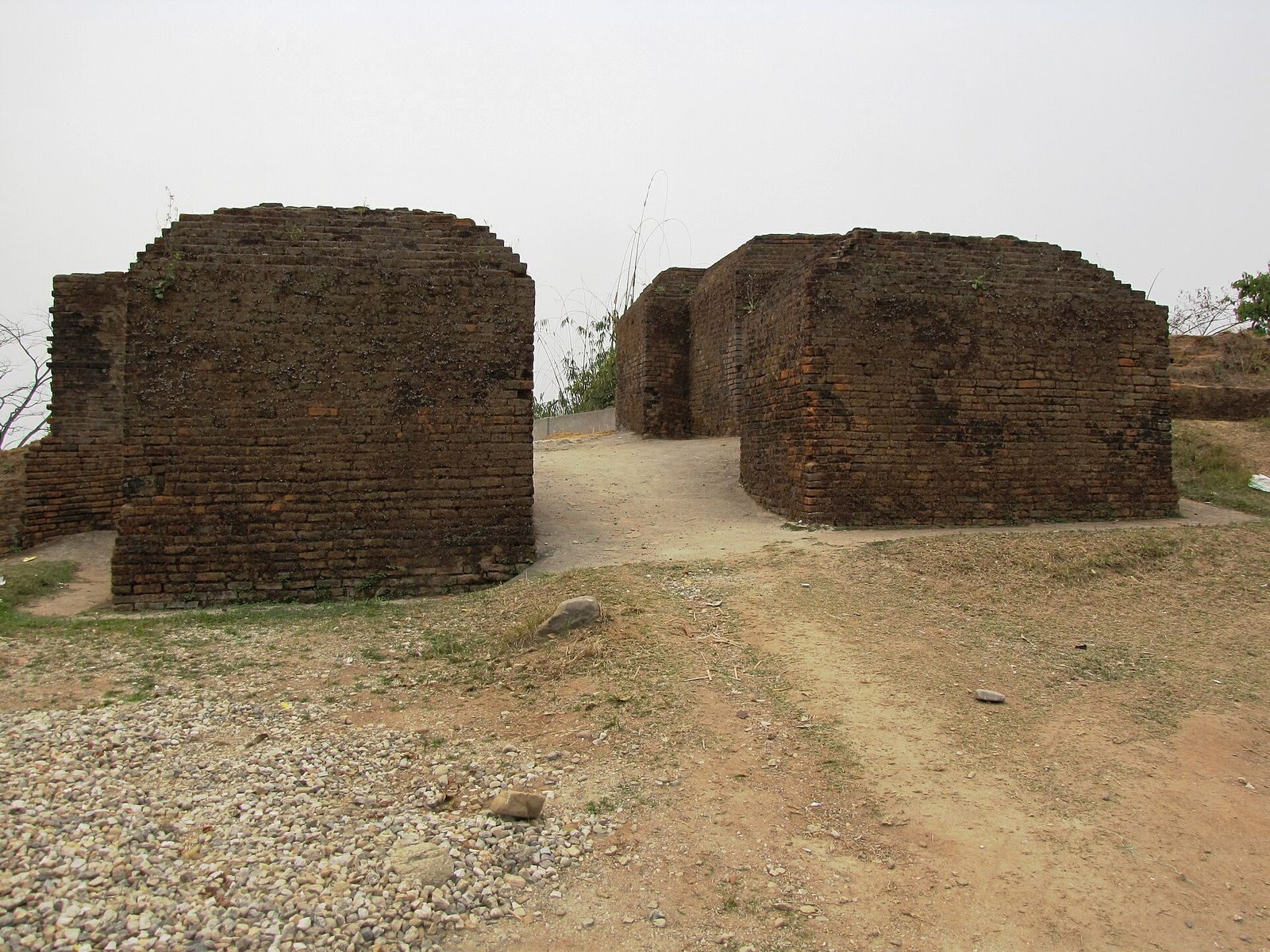
The eastern gate stands at the fort’s high point and faces toward Doimukh in the Dikrang valley. Its surviving fabric includes a stone-masonry base, and the gate is badly damaged. The western gate faces the Senkhi River and appears to have had fewer defensive features. The eastern and western entrances were positioned to command views over the lower Assam plains. The western gate lies within the central part of the present Itanagar Capital Complex, at about 379.17 metres above sea level; its associated enclosed area is about 2,643 square metres. The eastern gate is near Raj Bhavan, and its enclosed area is about 2,283 square metres.
Southern gate
The southern gate, at about 480 metres above sea level, faces Gohpur and Ramghat, with its position also allowing observation toward Pisoka. It is built mainly of brick, with some stone and stone slabs, and appears to have been the principal entrance and more strongly defended than the others. Two rooms inside the gate, one on either side, may have served soldiers, while a corridor may have run alongside its wall. The associated rampart extends about 340 metres and encloses roughly 15,105 square metres. Projecting and returning wall sections appear to create an offset approach instead of a direct opening through the defenses, an arrangement also found at Bhishmaknagar, Rukmini Nagar, and Chapakhowa Rajgarh.
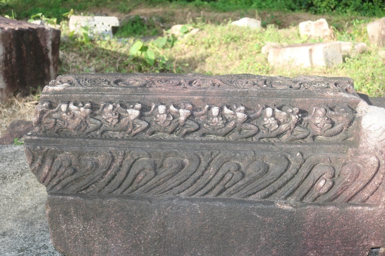
A stone door-jamb fragment bears images of a lion and an elephant, and animal and floral patterns are described on the gates. The shallow-relief lion carving has parallels at Bhishmaknagar, Tamreswari Temple, and Rukmini Nagar, suggesting a shared artistic vocabulary. The use of a stone base with brickwork above also has parallels at Tamreswari Temple and at a brick tank in a large medieval fort in the Sadiya area.
Settlement and finds
Settlement remains
Scattered bricks and structural debris within the enclosure point to a medieval settlement, rather than a fort used only as an isolated military post. The surviving remains also include ramparts, gates, stone masonry, and pottery fragments. Archaeological materials recovered at Ita Fort are displayed at the Jawaharlal Nehru Museum in Itanagar.
Pottery
The pottery includes coarse, heavily weathered fragments identifiable as bowls, pots, and spouted vessels. One fragment of spouted ware contains a substantial amount of kaolin, a fine clay mineral, in a quantity characteristic of medieval pottery from the Brahmaputra valley.