Fort Christanna: A Colonial Virginia Frontier Fort and School
Site at a Glance
- Rating
- 4.3
- Popularity
- Very Low
- Country
- United States
- Primary era
- Early Modern
- Eras represented
- Early Modern
- Civilizations
- British
- Site type
- Military
- Remains
- Fort
On this page9 sections
History
Fort Christanna was a colonial Virginia frontier fort and associated Indigenous settlement near Lawrenceville, Virginia, in the United States. Established in 1714, it was created under the direction of Alexander Spotswood, lieutenant governor of the Virginia Colony, during the Tuscarora War, an early-eighteenth-century conflict in the Carolinas and neighboring frontier regions that heightened concern over security and Indigenous relations. The fort served as a defensive outpost, trading center, and planned settlement, while also supporting a school that taught English language, Christian religion, reading, and writing.
Foundation and Colonial Policy
The Virginia House of Burgesses approved the project late in 1713, and the fort operated under the Virginia Indian Company, a colonial company with a monopoly over trade with Indigenous peoples on the Virginia frontier. Its name combined “Christ” with the name of Queen Anne, the British monarch who died later in 1714. Spotswood intended the settlement to protect allied Indigenous communities and colonists while bringing several Indigenous groups together under Virginia’s protection.
After construction, Spotswood visited communities in the region and encouraged them to settle near the fort. Saponi, Tutelo, Occaneechi, Nansemond, and Eno communities were associated with the settlement, while Monacan and Manahoac communities were also connected with Indigenous settlements around the fort. The Nottoway and Meherrin declined their allotted places because they did not wish to live near the other communities. The associated Indigenous allotment covered six miles square, or 36 square miles, while the initially surveyed settlement tract measured 36 acres.
The Fort and Its School
When Fort Christanna opened, Captain Robert Hicks became its commander and moved his family to the area. Maintained by one officer and twelve men of the Virginia Indian Company, it served as the westernmost outpost of the British Empire for about three successful years. Charles Griffin taught Indigenous children English, reading, writing, the Bible, and the Book of Common Prayer, the Church of England’s standard book of services and prayers. He taught as many as 100 children, although another contemporary report counted 77 pupils. Some Meherrin children also attended, and some Meherrin regarded them as hostages. The school’s exact position in relation to the fort remains uncertain.
Lieutenant John Fontaine stayed at Fort Christanna during 1715 and 1716 and recorded observations of the Indigenous communities, including approximately 45 to 50 Tutelo words and phrases. Reverend Hugh Jones also described the school and its pupils during the fort’s most successful period. Spotswood continued to take a close interest in the settlement and began building a nearby house, bringing his family there at one point in 1717. He eventually settled on another tract near Fredericksburg.
Closure and Indigenous Dispersal
Opposition from private traders, particularly William Byrd II, a Virginia planter, merchant, and political figure, helped bring an end to the Virginia Indian Company’s trading monopoly on November 12, 1717. In May 1718, a treaty with the Haudenosaunee, a confederation of Iroquoian nations centered in the northeastern woodlands, restricted their movement east of the Blue Ridge Mountains. The House of Burgesses then voted to discontinue the fort’s garrison. Griffin left in September 1718 for the Brafferton, an early-eighteenth-century school at the College of William & Mary established to educate Indigenous students, and Fort Christanna closed.
Saponi, Tutelo, and remnants of other Indigenous communities continued to live on the allotted land after the closure, especially at the village of Junkatapurse. Many moved south to live with the Catawba around 1728, while others moved north, including to Shamokin, Pennsylvania, in 1740. The Cayuga nation formally adopted them in New York in 1753. Descendants of families associated with Fort Christanna have been identified in Virginia and neighboring North Carolina. Colonists settled the surrounding area in large numbers, and Brunswick County was created there as a separate county in 1720.
Archaeology and Preservation
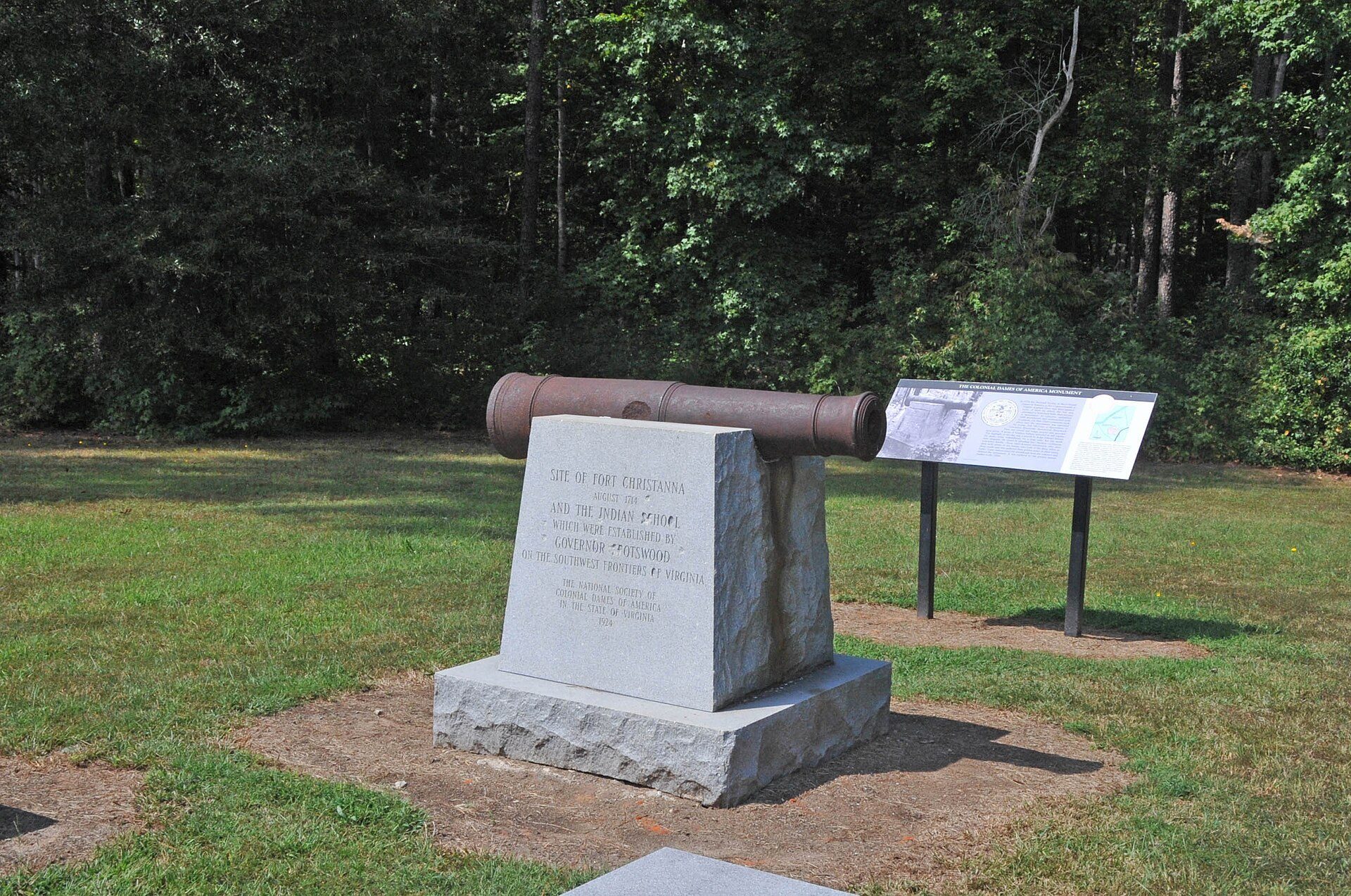
Archaeological excavations in the 1970s confirmed the fort’s location. Three campaigns, conducted in 1979, 1980, and 1981, examined its layout and appearance and substantially supported the historical descriptions. The Virginia chapter of the National Society of the Colonial Dames of America acquired about ten acres of the fort site in 1924 and erected a historical marker. The original marker was vandalized and replaced in 1960, and another marker across the Meherrin River was also replaced.
Brunswick County acquired approximately 25 additional acres of the original fort site around 2000. After further archaeological work and agreements involving the Colonial Dames and a local tourism association, the site became a park dedicated in 2004. Fort Christanna was placed on the Virginia Landmarks Register in 1979 and listed on the National Register of Historic Places in 1980 as a national historic district. The site is also included on the Virginia Civil Rights in Education Heritage Trail.
Remains
Fort Christanna stood on or overlooking the Meherrin River in what is now Brunswick County, near Gholsonville and close to the North Carolina border. The associated Indigenous settlement occupied land on both sides of the river. The historic district covers approximately 436 acres, or 176 hectares, while the surviving park outlines the former fortification and includes interpretive and wildlife trails.
Fortification Layout
The fort followed a pentagonal plan based on contemporary fortification principles. A blockhouse, a small fortified structure providing protected firing positions, stood at each of the five corners. Each blockhouse carried a cannon weighing approximately 1,400 pounds, and the corners were about 100 yards apart so that each position could command the next two within sight. Palisades joined the blockhouses, and an interior walkway ran along an earthwork rampart. The former corner positions are outlined in the present park.
Indigenous Settlement and School
Outside the fort, Indigenous communities established a town with cultivated fields of maize and tobacco. This settlement formed part of the wider community associated with Fort Christanna and extended across both sides of the Meherrin River. The school for Indigenous children belonged to the fort’s wider institution, although historical descriptions differ over whether the schoolhouse stood inside or outside the enclosure.
Associated Cannon
Tradition connects five large cannons with the fort’s corner blockhouses and places them in the fort’s well. A smaller cannon attributed to Fort Christanna stood for many years in the yard of a nearby private house, where it was fired on Independence Day and Christmas. In 1900, it was moved to the front of the Christopher Wren Building at the College of William & Mary.
Another smaller cannon attributed to Fort Christanna was kept in Lawrenceville. It exploded while being fired to celebrate Grover Cleveland’s election in 1887. In 1975, its remains were said to have been buried in the filled cellar of a former house.