Anar Citadel: A Sasanian-Era Fortress in Iran

Site at a Glance
- Rating
- 4.3
- Popularity
- Very Low
- Country
- Iran
- Primary era
- Classical
- Eras represented
- Classical, Medieval
- Civilizations
- Sassanid
- Site type
- Military
- Remains
- Citadel
On this page7 sections
History
Anar Citadel is a pre-Islamic fortified complex in Anar, Iran, associated with the Sasanian era, the Iranian empire that ruled from AD 224 to 651. Its development extended across several historical phases, with later work continuing into the Islamic period. The ancient population of Anar was Zoroastrian, following the Iranian religion centred on the teachings of Zarathustra and the worship of Ahura Mazda.
Ancient origins and later development
Before the Arab conquest of Iran, Anar was known as Aban. In antiquity, the town formed part of the province of Istakhr in Fars and had been within the territory of Kerman for approximately 1,500 years. Because its population was Zoroastrian, the earlier name has been tentatively connected with the Avesta, the principal body of Zoroastrian sacred texts, and with the Aban Yasht, a hymn dedicated to a sacred power.
The citadel developed during the Sasanian period and was completed during the Islamic period, according to archaeologist and university professor Alireza Jafari Zand. The Safavid dynasty, which ruled Iran from 1501 to 1736, repaired the complex and returned it to use. Jafari Zand has suggested that excavation and stratigraphic study, the examination of successive occupation and building layers, could reveal Parthian or even earlier phases beneath the Sasanian remains. The Parthian Empire ruled much of Iran from approximately the third century BC to the early third century AD, before the Sasanians.
Destruction and heritage protection
Much of the citadel’s interior was demolished in 1981–82, during the early years after the 1979 Iranian Revolution. The buildings were regarded as a place of corruption and were being used as shelter by drug addicts. A member of the Islamic Revolutionary Guard Corps was identified as responsible for the destruction. Some interior buildings, particularly two-storey rooms, had remained intact and usable roughly a quarter-century before 2011.
Anar Citadel has not undergone archaeological excavation or systematic archaeological research. It was registered as a national heritage site of Iran under number 30343 on 6 February 2011. The Kerman Provincial Cultural Heritage Administration is identified as its current owner. A foundation affiliated with Iran’s Armed Forces General Staff later proposed a 15-metre tomb for an unidentified war martyr about 100 metres from the citadel. Cultural-heritage activists objected that the proposal could endanger the site’s protective and visual buffer.
Remains
Fortified enclosure
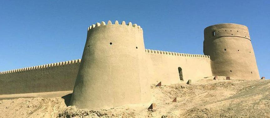
The citadel occupies approximately 11,179 square metres on a hill, with a rectangular plan elongated from east to west. Its elevated enclosure is surrounded by mud-brick ramparts and towers. The fortress therefore combines a raised position with a clearly bounded defensive perimeter, while its mud-brick construction reflects the material character of the surviving complex.
Perimeter and central buildings
One-storey spaces are concentrated mainly around the perimeter. They formed the commoners’ section and served service and residential purposes, including stables, other shelters for animals, accommodation for ordinary residents, and quarters for household servants.
The centrally placed two-storey buildings formed the governmental headquarters and political centre of the citadel. Their precise plan, internal spaces, component elements, and arrangement remain subjects that archaeological excavation could clarify. The interior formerly included rooms and buildings with two-storey spaces, although the buildings are also described as sometimes reaching three storeys.
Entrances and surviving fabric
The principal entrance lies on the southern side of the fortress along Razi Street. A second entrance on the northern side, positioned between two towers, was created through destruction during the early post-revolutionary period. These entrances and the surviving ramparts provide the clearest framework for understanding the citadel’s enclosure, while the remaining mud-brick buildings preserve parts of its residential, service, and governmental organization.