Kangra Fort: A Historic Hill Fortress in India
Site at a Glance
- Country
- India
- Primary era
- Medieval
- Eras represented
- Medieval, Early Modern, Modern
- Civilizations
- Mughal, Sikh Empire
- Site type
- Military
- Remains
- Castle
On this page23 sections
History
Kangra Fort is a hilltop stronghold in Kangra, India, built by the Katoch Rajput dynasty. Katoch tradition places its beginnings around 1500 BCE, while the oldest surviving structures date to the ninth or tenth century CE. References to the fort extend back roughly 4,000 years, and it also appears in Indian mythology. Control of the fortress and its surrounding lands passed among local rulers, the Mughals, Sikh powers, and the British.
Early history and medieval campaigns
In 1009, Mahmud of Ghazni captured Kangra during what is described as his fourth Indian campaign. His court historian Utbi wrote that Mahmud took away substantial wealth. The fort and its treasure may have been held by the Shahi dynasties, medieval rulers associated with Kabul and Punjab. Mahmud’s forces remained at Kangra until 1043, when help from the ruler of Delhi brought the rule of his successors to an end. Local rulers are believed to have controlled the fort for the next three centuries.
Muhammad bin Tughluq is said to have captured Kangra in 1337, but the story is disputed and may have been invented to conceal his failure in a campaign against China. Firuz Shah Tughluq captured the fort in 1351, then attacked it in 1365 in response to Raja Rup Chand’s raids near Delhi. The result of that assault is uncertain, and local rulers continued to govern Kangra. In 1540, Khawas Khan Marwat, a leading general of Sher Shah Suri, captured and plundered the fortress. Local rulers later regained or retained control.
Mughal contest and control
In 1556, Raja Dharam Chand accepted the authority of the Mughal emperor Akbar and agreed to pay tribute. Dharam Chand and his successors Manikya Chand and Jaya Chand continued to rule at Kangra. After Akbar lost confidence in Jaya Chand, he ordered his Punjab representative, Khan Jahan, also known as Husain Quli Khan, to attack in 1571. Akbar had promised the fort’s government to Birbal, a senior court figure. The Mughal force agreed to peace after learning that Ibrahim Husain Mirza and Masud Mirza had begun an uprising in Punjab. The settlement required tribute to Akbar and included other terms.
Akbar’s successor Jahangir made the fort’s capture a priority. One traditional explanation for his interest tells that a parrot belonging to Kangra prince Trilok Chand had been refused to Prince Salim, who later became Jahangir. The Mughal commander Sheikh Farid Murtaza Khan began an assault in 1615 with help from Raja Suraj Mal of Nurpur, but disagreement ended the campaign. A second attempt in 1617 was abandoned after Suraj Mal rebelled. Jahangir then sent a larger force under Sundar Das and Rai Rayan. After a siege of a year and two months, Mughal forces took Kangra in 1620–21. In 1620, Jahangir killed the Katoch ruler Raja Hari Chand as he brought the Kangra kingdom into the Mughal Empire.
Jahangir visited Kangra with Nur Jahan in 1621–22. During one visit, he is said to have ordered a bullock slaughtered at the fort. He also began a palace at nearby Moja Gudkari, but the building was never finished. Mughal rule continued until 1783. Nawab Ali Khan was the first Mughal governor, followed by his son Harmat Khan. Under Shah Jahan, the governors included Nawab Asadullah Khan and Koch Khili Khan, who died at Kangra and was buried beside the Mununi, a branch of the Banganga. Governors under Aurangzeb included Syed Husain Khan Hasan, Abdullah Khan Pathan, and Nawab Syed Khalil Khan. Nawab Saif Ali Khan, appointed in 1743, was the last Mughal governor.
Katoch restoration and Sikh rule
As Mughal power weakened, the Katoch rulers grew stronger in the surrounding region. In 1758, the Afghans recognized Gamand Chand as their representative in the Jalandhar Doab, the region between the Beas and Sutlej rivers. He failed to take Kangra, but his grandson Sansar Chand II renewed the effort with help from Sikh leader Jai Singh Kanhaiya. Jai Singh captured the fort in 1783, after Saif Ali Khan’s death; the terms allowed the Mughal governor’s son safe passage. Sansar Chand recovered Kangra through a treaty in 1786, making territorial concessions to Jai Singh.
Sansar Chand expanded into the plains and annexed Bilaspur, while Maharaja Ranjit Singh blocked his westward advance near Hoshiarpur. The ruler of Bilaspur sought help from Nepal, and Gurkha forces under Amar Singh Thapa invaded the Kangra region in 1806. Reinforced by Kaji Nain Singh Thapa, they besieged the fort in 1807. By early 1809, Nepalese forces controlled much of the Kangra jagir, an assigned territory or revenue estate, but the fort still held out. Sansar Chand turned to Ranjit Singh for aid. The Gurkhas were defeated in the Nepal–Sikh war of 1809 and driven back across the Sutlej.
In May 1809, Sansar Chand again asked Ranjit Singh to help recover the fort. The two rulers reached an agreement at Jawalamukhi, and Ranjit Singh took Kangra after heavy fighting. The fort and its associated lands, comprising 66 villages, passed to Ranjit Singh; Sansar Chand retained the rest of Kangra Valley. The fortress remained under Sikh rule until 1846.
British rule and the earthquake
During the First Anglo-Sikh War, fought between the Sikh Empire and the British in 1845–46, British forces captured Kangra after a six-week siege that ran from mid-April to 28 May 1846. Sir Henry Lawrence arrived on 3 May. The fighting was the only battle between the Kangra Sikh forces and the British. Under the Treaty of Lahore, the defeated Sikhs ceded the Jalandhar Doab, including the fort, to the British.
A British garrison occupied the fortress until an earthquake on 4 April 1905 severely damaged it and the surrounding area. Kangra Fort was declared a monument of national importance in 1909 and is protected by the Archaeological Survey of India, India’s national agency for archaeological research and monument protection.
Jain heritage
Kangra was once an important Jain centre, but the community declined after Jain residents left the town. A local legend tells of King Suśarmācandra, who vowed not to eat or drink until he had paid homage to Rishabhanatha at Palitana, an important Jain pilgrimage site. To save the king from starvation, the goddess Ambika is said to have created a shrine to Rishabhanatha in his fort. After paying homage to the image, the king ended his fast.
In 1916, the Jain monk Muni Jinavijaya published an account of a pilgrimage to Nagarkot and Kangra, describing pilgrims’ journeys from Faridpur and their return by another route. During a visit to Kangra Valley in 1930, Dr. K. N. Sitaram identified Jain images and temple remains. He also noted that some had been adopted by Hindus and associated with different Hindu deities. In 1978, the image of Rishabhanatha was installed in a separate shrine within the fort. The Archaeological Survey of India cares for it, while Jains retain the right to worship there.
Remains
The fort covers 463 acres on a hillock at the foothills of the Dhauladhar range. It is described as the largest fort in the Indian Himalayas. Its principal levels rise from the gateways toward a temple terrace and the remains of the royal palace at the summit. Seven gateways lead toward the main palace area, and the fort had 23 bastions, or projecting defensive positions.
The hill rises about 300 feet above the Banganga River and stands at an elevation of 700 metres, between the Manjhi River, also called the Mansi or Benner, and the Banganga. The Mununi, a branch of the Banganga, is another nearby watercourse. Steep riverbanks border three sides, leaving access from the town to the northeast. During royal rule, vegetation on the steep banks was cleared to improve observation. High ground across the river to the north contains the Jayanti Mata temple.
Approach and gateways
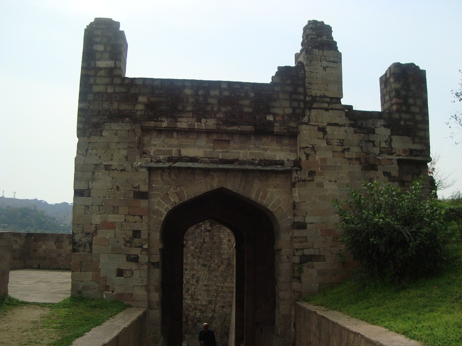
A long, narrow, winding passage climbs through the gateway system. The outer entrance has a small courtyard between two gates attributed to the Sikh period. An inscription above the entrance gives their date. About 500 feet farther along, the passage turns sharply before continuing through the Jahangiri Darwaza.
Ranjit Singh Gate
The Ranjit Singh Gate is the lowest entrance and the last gateway added to the fort. Built during Ranjit Singh’s rule, it has two doors fitted with wooden leaves. A trench in front of it connects the rivers on either side of the hill.
Ahani and Amiri gates
The Ahani and Amiri gates are attributed to Mughal governor Nawab Saif Ali Khan. Ahani takes its name from the iron bars and bands that once secured it; the gate now has no doors.
Jahangiri Darwaza
Beyond a sharp turn in the approach, the Jahangiri Darwaza bears an inscription giving the date of the Mughal capture. Jahangir added the gateway after taking the fort.
Andheri Darwaza
The narrow Andheri Darwaza, also called Handeli Darwaza, has high walls on both sides and is now ruined. Its name may refer to the confined, dark passage. Beyond it, one route leads out toward the far side of the fort, past Jahangir’s mosque and two tanks; another continues toward the upper precincts and the Darsani Darwaza.
Darsani and Palace gates
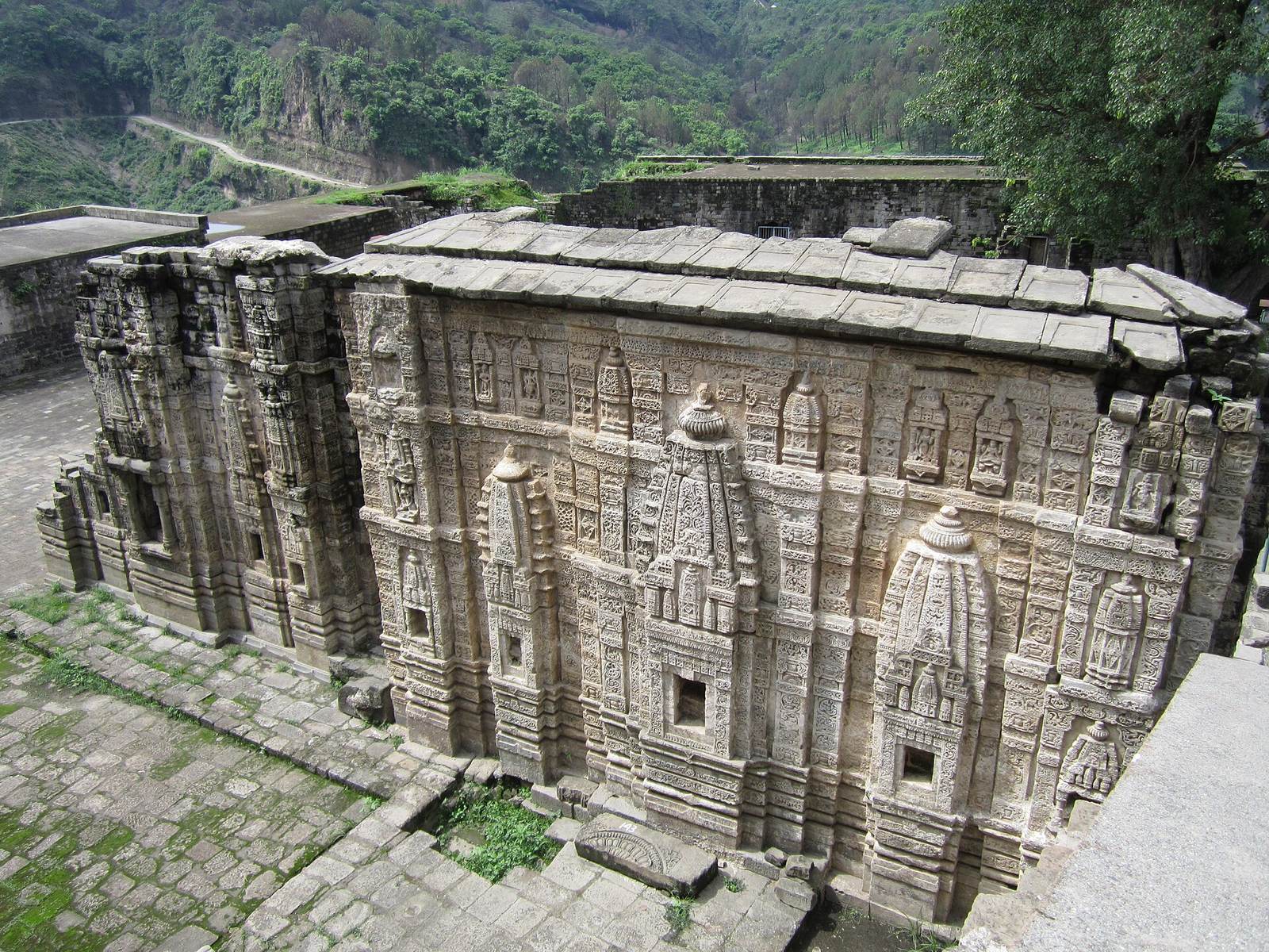
The Darsani Darwaza opens onto the temple terrace and is associated with the oldest part of the fort. Sculptures of the river goddesses Ganga and Yamuna flank the entrance, though their faces are damaged. Beside the Lakshmi-Narayana temple, the Palace Gate leads from the terrace toward the upper palace level.
Temple terrace and palace level
The terrace below the palace contains remains of three shrines, while the uppermost terrace holds the remains of royal buildings. Their positions form the fort’s principal sequence of religious and royal precincts.
Lakshmi-Narayana shrine
The Lakshmi-Narayana shrine faces the gateway. Only scant remains of the structure survive.
Ambika Devi temple
The terrace also contains the remains of the Hindu temple of Ambika Devi.
Jain temple
A large Jain temple once stood on the terrace. Its remains form the third shrine group on this level.
Royal palace buildings
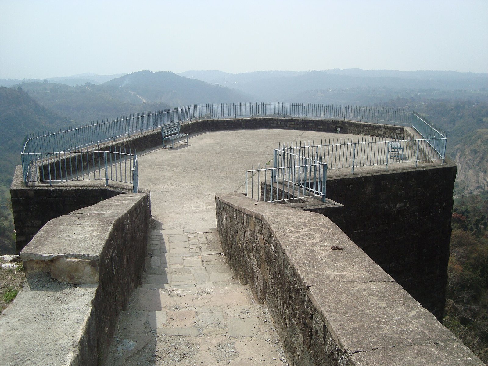
The uppermost terrace contains the remains of the royal-palace buildings. A large polygonal bastion stands at its southwest end.
Jain image of Rishabhanatha
The granite image of Rishabhanatha, also called Adinatha, shows the deity seated in the lotus posture. A bull carved on the pedestal identifies him as the first Jain Tirthankara, or spiritual teacher. An inscription on the pedestal, written in Sharada, a historical script used in northern India, records consecration in 854 CE by the Śvetāmbara monk Amalacandra. It names him as a disciple of Acharya Abhayacandra, a senior religious teacher in the Rajakula Gachha, a Jain monastic lineage. The image has also been dated to around 1446, so its date remains uncertain. Carved curls beside the head and the inscription led archaeologist Sir John Marshall to identify the image and temple as Śvetāmbara Jain. The figure lacks the waistband and draped garment common on Śvetāmbara Tirthankara images after the period of the monk Bappabhattisuri. The image was found in Indreshvara Temple before it was placed in its separate shrine at the fort.
Mosque, tanks, and other features
Jahangir’s mosque and Kapoor Sagar
Jahangir’s mosque survives in ruins beside the route beyond the Andheri Darwaza. It was later used to store gunpowder and was damaged by British cannon fire. The tank called Kapoor Sagar lies beside the mosque.
Bathhouse and water pool
Outside the fort gates stands a bathhouse built in the Mughal style during Nawab Ali Khan’s tenure. A nearby pool supplied its water. The pool’s design suggests that it may date to a period of Hindu rule, and its water originally came from a natural spring.
Reported passage to the river
Tradition holds that a concealed passage runs from the upper fort down toward the river. According to the story, Sansar Chand used it to escape during the Gurkha attack.