Angel Mounds: A Middle Mississippian Chiefdom Center
Site at a Glance
- Popularity
- High
- Country
- United States
- Primary era
- Medieval
- Eras represented
- Medieval
- Civilizations
- Mississippian
- Site type
- City
On this page22 sections
History
Angel Mounds is a large Middle Mississippian residential and agricultural settlement in the United States, built by Indigenous people after AD 1000 and occupied mainly from about AD 1100 to 1450. Middle Mississippian culture was a regional expression of a precontact Indigenous tradition based on settled communities, intensive farming, exchange, and large earthen mounds. Angel Mounds became the political, cultural, and economic center of the Angel chiefdom, a society in which a chief held authority beyond a single settlement.
The Angel community
The settlement is generally dated to about AD 1100–1450, although broader estimates of occupation range from roughly AD 1000 to 1600. Radiocarbon estimates place its development around AD 1200–1500. Archaeologists later named the local period the Angel phase. Marjory Honerkamp introduced the name in the 1970s, and pottery styles helped researchers, including Sherri Hilgeman, distinguish it from the earlier Yankeetown phase, dated AD 750–1000, and the later Caborn-Wellborn phase, dated AD 1400–1700.
Angel was a regional trading center whose influence extended from the Ohio River valley toward the Green River in present-day Kentucky. Its residents exchanged goods with communities along the Ohio and Mississippi rivers. Nearby villages, hamlets, farmsteads, and camps are understood to have been politically subordinate to the central settlement. The community’s location amid fertile Ohio River bottomlands supported farming. Residents grew maize, beans, and squash, while hunting and fishing also contributed to their food supply. Flood-replenished soils helped sustain crop surpluses, exchange, and a comparatively dense population.
At its peak, the town may have held about 1,000 people. Archaeologist Glenn A. Black estimated that it contained around 200 households. Angel Mounds is grouped with Kincaid, Wickliffe, and Tolu in the archaeological category known as the Kincaid Focus, based on similarities in pottery and settlement plans. Comparisons of these sites have led some scholars to suggest that their residents belonged to the same society.
Decline and abandonment
The settlement is believed to have been abandoned around AD 1400, and the Angel chiefdom had collapsed by about AD 1450. By around AD 1650, Mississippian communities had left the wider Ohio River valley. The cause of Angel’s decline remains uncertain. Possible explanations include extended drought and diminishing natural resources, potentially compounded by overhunting and the clearing of forests for building materials and fuel. Some residents may have moved downriver toward the meeting point of the Ohio and Wabash rivers.
Protection and archaeological research
The site takes its name from the Angel family, which began purchasing farmland there in 1852. Mathias Angel was among the settlers who acquired land containing the archaeological settlement. In 1931, archaeologist Warren K. Moorehead urged Eli Lilly to help secure the site. The Indiana Historical Society bought 480 acres from Angel family descendants and others in 1938, using funds supplied by Lilly. The purchase was intended to protect the archaeology from a planned levee and real-estate development. Elda Clayton Herts later gave the society 20 acres that included a mound from the Early Woodland period, an early archaeological period in eastern North America that preceded Mississippian culture.
Surveying and clearing began in 1938–1939. From 1939 to 1942, more than 250 Works Projects Administration workers excavated about 120,000 square feet under Black’s direction. The Works Projects Administration was a New Deal public-works agency, part of the federal economic recovery program created during the Great Depression. The excavation focused on residential areas to investigate daily life. Because many workers lacked archaeological field experience, Black adapted standardized recording forms used at the University of Chicago.
Work paused during World War II and resumed in 1945 through Indiana University’s summer archaeology field school, which has continued at the site. From 1958 to 1962, researchers tested geophysical survey methods to locate buried sections of the palisade. These included proton magnetometry, which measures changes in magnetic fields to help find features underground. The Indiana Historical Society transferred ownership to the State of Indiana in 1946 while retaining excavation rights, then transferred those rights to Indiana University in 1964. Angel Mounds became a National Historic Landmark in 1964 and joined the National Register of Historic Places in 1966. The Indiana State Museum and Historic Sites manages the property, while Indiana University’s Museum of Archaeology and Anthropology oversees archaeological research.
Tribal collaboration and reburial
Angel Mounds preserves evidence of Middle Mississippian life along the Ohio River and Indigenous culture before European contact. Its interpretive center and exhibits were developed with the Miami Tribe of Oklahoma, the Osage Nation, the Quapaw Nation, the Shawnee, and others. Excavations uncovered more than 300 burials, mostly in the eastern village. Over subsequent decades, 725 people and about 15,000 funerary objects were removed from burials. In 2021, eight federally recognized Tribal Nations affiliated with the site worked with Indiana University’s Native American Graves Protection and Repatriation Act office and the Indiana State Museum to rebury more than 700 ancestors at Angel Mounds. The federal law governs the return of Native American human remains and certain cultural items to affiliated Indigenous communities.
Remains
The archaeological settlement covered about 100 acres on terraces above the Ohio River floodplain. The river bordered the town to the south, where Three Mile Island lay between the settlement and the water. The community faced south across a narrow channel toward the island and present-day Kentucky. A channel and a slough, a slow-water channel, bordered the settlement to the north, east, and west. These waterways provided canoe access, freshwater for fishing, drinking, and bathing. The slough was once deeper and kept clear of brush and trees; by 1939 it had dried up, while the channel had eroded.
Earthen mounds
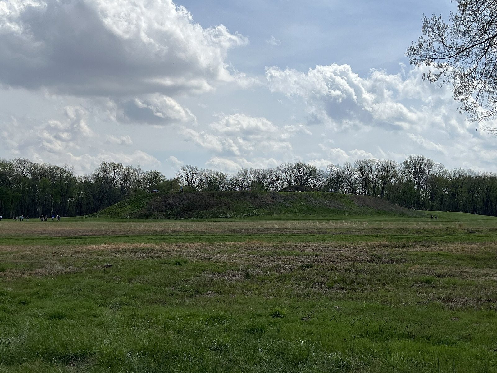
The town contained thirteen earthen mounds and at least one large plaza; eleven mounds survive, many damaged before the site was protected. Six large platform mounds, meaning raised structures with generally flat tops, are designated A through F, and five smaller mounds are designated H through L. Mound G is older than the others and may not belong to the Angel phase. Mounds I and K may have been built over earlier mound structures. Mounds A, E, and F have level-topped, truncated-pyramid forms with square or rectangular bases.
Mound A
Also called the Central Mound, Mound A is the largest and highest of the complex, rising about 44 feet (13 m). Its base measures 644 by 335 feet (196 by 102 m), and its several levels include a small conical mound at the southeast corner of the upper level. The southern lower terrace measures 100 by 100 feet (30 by 30 m); the upper terrace stands 28 feet (8.5 m) above the surrounding ground. Builders carried about 67,785 cubic yards (51,825 cubic metres) of earth in baskets from the waterway to the south. The mound was probably the hereditary chief’s residence. Its height also fits the interpretation that people of higher status occupied larger mounds. Built around AD 1050–1100, it remained in use until abandonment and was then burned. A modern stairway limits erosion from foot traffic; archaeological evidence suggests that a wooden stairway may have existed in the past.
Mound F
Known as the Temple Mound, Mound F measures 235 by 239 feet (72 by 73 m) and stands 14 feet (4.26 m) high. It is the only mound excavated in full. The sequence of construction shows buildings at ground level and on a second occupation layer before mound fill covered domestic structures. A large rectangular building with at least two rooms and attached entrance rooms or covered porches stood on the primary mound surface. Disturbance from the historic period makes it uncertain whether the final mound surface held a building. Mound F was built around AD 1050–1100, used until the community’s abandonment, and then burned. Excavation removed the mound, which was later reconstructed with a temple building, a surrounding palisade, and stairs to the summit.
Mound E and other mounds
Mound E, the third largest, measures 160 by 140 feet (49 by 43 m), with an upper platform 45 by 40 feet (14 by 12 m). Because it was never cultivated, it provides the best-preserved example of the settlement’s level-topped mound form. The other surviving mounds contribute to a complex of structures that includes both large platforms and smaller earthworks.
Fortifications
Palisades and defensive projections
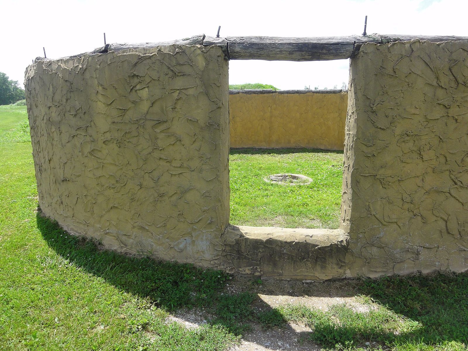
An outer palisade, a defensive fence of upright posts, enclosed the town, while an inner one divided its interior. The Ohio River formed the southern boundary, and the entrance is thought to have been near the southwest corner. A second barrier, resembling a picket fence, ran parallel to the outer wall about 14 feet (4.3 m) beyond it, apparently to impede attackers. The walls, about 12 feet (3.7 m) high, were made of woven sticks coated with mud-and-grass plaster. Defensive projections, called bastions, extended 10–11 feet (3.0–3.4 m) from the walls at intervals of about 120 feet (37 m). A section of wall was reconstructed in 1972 from archaeological evidence. Its posts extend about 4 feet (1.2 m) into a narrow trench, and woven sticks with mud-and-grass plaster form the wall covering. Defensive projections were reconstructed as well.
Homes, gathering places, and production
Houses
When a house became unusable, its residents burned it and built a replacement over the ashes. Black proposed that house walls were made from cane coated with mud and straw. The roofing material is uncertain, although he suggested grass thatch. Infant remains were occasionally found beneath house floors, forming part of the evidence for how burial places were distributed within the settlement.
Plaza and circular buildings
A public plaza is believed to have stood between Mounds A and F. Two excavated circular buildings may have served as sweat lodges or meeting places.
Pottery workshop
Excavation in 2006 identified a probable pottery-making workshop. Finds included pottery tools and large amounts of prepared, slightly fired clay. They suggest that partly made pieces were kept there before being finished and fired as bowls, jars, or figures.
Artifacts and burials
Pottery
Excavations recovered nearly two million pottery fragments, including 4,569 pieces of negative-painted pottery, in which designs remain unpainted against a painted background. Some pottery carries textile patterns on its interior. Pottery associated with the settlement includes shell-tempered wares, made with shell mixed into the clay, ranging from coarser smoothed surfaces to finer, more polished finishes.
Carved fluorite figure
A carved fluorite statue of a seated man was found at Mound F in November 1940. It is 8.5 inches (22 cm) tall and weighs 11.5 pounds (5.2 kg).
Tools and subsistence
Tools and weapons were made from igneous and sedimentary rock, sandstone, slate, shale, diorite, and cannel coal; metal objects were rare. Recovered materials also include animal and bird bones, antler, shells, and animal teeth. Bone fishhooks, cord nets for catching mollusks and freshwater fish, and spears with projectile points for hunting small game are among the equipment inferred for fishing and hunting.
Burial places
Burials occur across the settlement, especially in the eastern village, and also beside Mound F, at Mound I, and near the palisade walls. Infant remains were sometimes placed beneath house floors.
Present property and collections
The historic property covers more than 600 acres and includes an interpretive center, reconstructions of Mississippian structures, and a replica of the 1939 Works Projects Administration archaeology laboratory. A separate 500-acre area beyond the archaeological settlement is maintained as a nature preserve. Angel Mounds artifacts and associated archaeological records are curated at Indiana University’s Museum of Archaeology and Anthropology in Bloomington; a preservation effort rehoused the collections.