La Quemada: A Pre-Hispanic Ceremonial and Defensive Centre in Zacatecas
Site at a Glance
- Rating
- 4.7
- Popularity
- Medium
- Country
- Mexico
- Primary era
- Medieval
- External website
- Open
- Eras represented
- Classical, Medieval
- Civilizations
- Purépecha, Teotihuacan, Toltec
- Site type
- Military
- Remains
- Fortified Town
On this page20 sections
History
La Quemada is a pre-Hispanic archaeological site on a hill in the Malpaso Valley of Zacatecas, Mexico. Developed by regional societies whose cultural and political identity remains debated, it occupied about 0.5 square kilometres and controlled an important route leading south from the valley. Its main development belongs to the Late Classic and Early Postclassic sequence, with recent radiocarbon research placing its principal occupation approximately between AD 500 and 900 and its greatest florescence around AD 650 to 750.
Origins and regional connections
The settlement formed part of a wider cultural landscape associated with the Chalchihuites tradition, a north-central Mexican tradition linked to mining, ceramics, settlements, and long-distance exchange. Earlier interpretations placed La Quemada within that tradition, while other research has treated it as an independent ceremonial centre of the Malpaso Valley. Differences between its local ceramic decoration and Chalchihuites pottery have contributed to the continuing debate over its identity.
From approximately AD 350 to 700, La Quemada participated in a trade network connected with Teotihuacan, the major urban and political centre of central Mexico during the Classic period. The network extended from northern Zacatecas to the Valley of Mexico and included settlements in the Altos de Jalisco and northern Guanajuato. Minerals, salt, shells, feathers, obsidian, peyote, and other goods circulated through these connections. They may have been managed by local elites, regional intermediaries, or small groups of Teotihuacan merchants living at different centres.
The settlement developed through repeated rebuilding. During an earlier phase dated approximately AD 400 to 600 or 650, construction established the foundations of the later complex. The La Quemada phase, dated approximately AD 600 or 650 to 850, brought the construction of terraces, ceremonial facilities, residential areas, small pyramid platforms, and courtyard complexes.
Regional centre and defensive transformation
Between approximately AD 700 and 1100, La Quemada no longer participated in the earlier exchange network in the same way. It became a dominant regional exchange centre that competed with neighbouring settlements. Its defensive character grew stronger, particularly during the later Citadel phase, conventionally dated approximately AD 850 to 1050. A substantial wall was built mainly along the northern side, while two stairways and other routes were restricted or closed.
During this final occupation, buildings, stairways, and passageways were altered or reduced. Hearths were later built over collapsed roofs, and charcoal from one such hearth produced a date of approximately AD 930 ± 120. The settlement subsequently declined and was abandoned. The name La Quemada has been explained either through Spanish observations of burned ruins or through a hacienda that burned and passed its name to the site. The extent and meaning of the fire evidence remain uncertain.
Chicomoztoc and later interpretations
Colonial writers connected La Quemada with Chicomoztoc, the legendary “Place of the Seven Caves” associated in later Nahua traditions with the origins or migrations of several Nahua-speaking peoples, including the Mexica. In 1615, the Franciscan historian Fray Juan de Torquemada identified the site as a place visited by the Mexica during their migration, where elderly people and children were left behind. In 1780, the Jesuit historian Francisco Javier Clavijero associated it with the place where the Mexica supposedly stayed for nine years while travelling toward Anahuac.
This tradition became widely known, but archaeological evidence does not identify La Quemada as Chicomoztoc. Other interpretations have described the site as a Caxcan settlement, a Toltec trading post or military outpost, a fortress against Chichimeca groups, a centre linked to Teotihuacan, a Purépecha or Tarascan centre, or a capital of northern groups. Its cultural and political affiliations therefore remain under discussion.
Archaeology and preservation
La Quemada was known by the seventeenth century. In the early nineteenth century, Zacatecas governor Francisco García Salinas commissioned the German engineer Carlos de Berghes to map the ruins and their road network. His work contributed to the development of some of Mexico’s earliest cultural-heritage preservation legislation.
Pedro Armillas investigated the site in 1951 and 1963 and used it to develop a three-period chronology for the Malpaso Valley. Research from the 1980s onward revised earlier interpretations that had directly connected La Quemada with Mexica migration traditions. Mexico’s National Institute of Anthropology and History manages the archaeological zone, which is included on Mexico’s Tentative List for World Heritage.
Remains
La Quemada occupies a hill of approximately 2,100 metres elevation and is arranged largely along a north to south axis. Its principal groups are the elevated Citadel or Acropolis, the central Palace complex, and the southern group containing the Votive Pyramid and Hall of Columns. The southern and southeastern slopes contain the greatest concentration of ceremonial architecture, while terraces on the western slope are interpreted mainly as residential areas.
The site consists of masonry platforms of varying sizes built against the hill to support superstructures. Earlier buildings were incorporated into later masonry cores and covered with fills, revealing successive phases of rebuilding. Rhyolite slabs quarried from a hill northeast of the Votive Pyramid form the principal building material. Clay mixed with vegetal fibre served as mortar, and the walls were coated with several layers of clay plaster and a polished lime finish. Only small sections of the surface finish survive.
Citadel and principal complexes
Citadel
The Citadel occupies the highest part of La Quemada and contains buildings interpreted as possibly ceremonial and defensive. Its enclosing wall follows the northern and northeastern edges of the site, including areas beside steep slopes. The wall is approximately 800 to 850 metres long, 3 to 4 metres thick, and 4 to 5 metres high.
Palace and southern Temple
The central Palace and the southern Temple form the other two principal complexes. Their surviving structures belong to the hilltop architectural arrangement, although the original functions of all buildings within these groups are not established.
Hall of Columns
The Hall of Columns is an enclosure measuring approximately 41 by 32 metres and probably more than 5 metres high. Eleven internal stone columns stood in three rows containing four, two, and five columns. They supported or helped support the roof, while parts of the surrounding walls survive to about 3 metres. Its original function is unknown. Earlier research interpreted it as a ceremonial building possibly associated with human sacrifice, but that proposal is not conclusive.
Avenues, roads, and ceremonial movement
The Main Avenue begins at the plaza in front of the Hall of Columns and runs for approximately 400 metres before continuing through smaller roads toward the Malpaso Valley. Its related roads had lateral stone walls, surfaces made from stone slabs, and paving of clay and small stones. At least two altar remains were recorded near the entrance of the Main Avenue.
Roads and causeways radiated through the valley from La Quemada. Some were approximately 10 metres wide and were bounded by walls made from slabs and rounded stones. Their interiors were levelled with slabs and paved with clay and small stones. The system extended for more than 170 kilometres and connected La Quemada with more than 220 smaller settlements.
Platforms, terraces, and ballcourts
Ballgame court
The principal ballgame court was built on a platform measuring approximately 70 by 15 metres. It has the characteristic I-shaped plan of a Mesoamerican ballcourt, a formal space used for a ritual ballgame. Its lateral walls are about 2.70 metres thick and probably stood between 3 and 5 metres high.
Terrace 18
Terrace 18, northwest of the Citadel, is among the largest terraces, measuring approximately 70 by 40 metres. Its northwestern end contains a small temple-like structure about 6 by 10 metres across and a sunken courtyard, a courtyard below the surrounding platform level, measuring approximately 15 by 35 metres. A small ballcourt was built inside the courtyard. Its plastered walls were renewed several times, and a headless stone sculpture of a ballplayer was found at the end of one wall.
Residential terraces
Numerous terraces and platforms occupy the western side of the hill, particularly in the third-level sector. They are interpreted as residential areas. Approximately 25 platforms are thought to have been built around AD 650, while broader reconstructions estimate between about 60 and 100 terraces and enclosed structures during the La Quemada phase.
Southern monumental group
Votive Pyramid
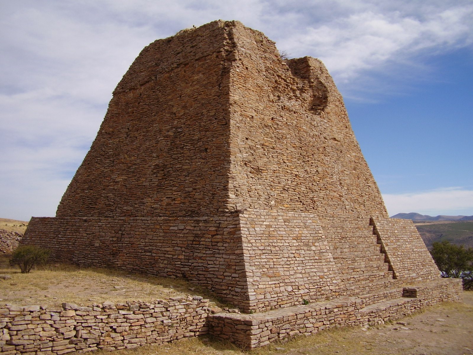
The Votive Pyramid is a steep-sided structure approximately 9 to 10 metres high. Investigations in 1995 identified a stairway on its southern side. The middle and upper sections collapsed and lie at the base of the pyramid. The stairway probably reached a summit room or temple made from perishable materials, although another interpretation holds that the summit originally ended in a pointed form rather than supporting a conventional temple.
Major stairway
A major stairway lies approximately 30 metres west of the Votive Pyramid. It was built in at least two stages. The earlier section apparently reached a middle landing and may have been rounded, while the later upper section reached a second-level walkway and connected with a double ramp leading toward a third level. The principal stairway was later blocked or restricted as part of the site’s defensive transformation.
El Cuartel and the Pyramid of the Sacrifices
El Cuartel is probably a housing structure whose roof caught fire and collapsed. Another structure, identified in one description with Structure and Terrace 18, is known as the Pyramid of the Sacrifices. It has traditionally been interpreted as a place where human sacrifices to the gods may have been performed, with young women and children proposed as possible victims. This interpretation remains uncertain.
Exchange evidence and museum
Objects recovered at La Quemada reflect long-distance exchange. Obsidian came mainly from sources in northwestern and western Mexico, including areas of northern Michoacan, central Jalisco, and Cerro de Navajas in Hidalgo. Turquoise came from Cerrillos in New Mexico. Imported pottery and figurines include material associated with Alta Vista de Chalchihuites and the Bolanos culture of San Luis Potosi. Refined ceramics resembling cloisonne ware place La Quemada within an exchange network extending toward Jalisco.
A site museum within the archaeological zone uses stone slabs, stucco, and surface finishes characteristic of La Quemada in its design. It contains a scale model and videos concerning the archaeological development of Zacatecas and the settlements of La Quemada, Loma San Gabriel, and Chalchihuites.