Kalamata Castle: A Historic Fortress in Greece


Visitor Information
Google Rating: 4.2
Popularity: Medium
Google Maps: View on Google Maps
Country: Greece
Civilization: Unclassified
Remains: Military

History
Kalamata Castle stands in the municipality of Kalamata, Greece, on a hillside that once hosted the ancient city of Pharae. This strategic location, overseeing the Nedon river on its path from Mount Taygetos to the Messenian Gulf, has seen continuous use since antiquity. The earliest known fortifications here date back to the Byzantine period and are confirmed from the 10th century, initially serving defensive and religious purposes.
By the early 13th century, the original Byzantine walls had deteriorated, and the site was converted into a monastery. Following the arrival of Crusader forces, who established the Principality of Achaea after the conquest of the region, the castle was rebuilt and significantly expanded to meet military needs. It became the stronghold and administrative center of the Barony of Kalamata, held by the prominent Villehardouin family. William II of Villehardouin, a key figure of the Frankish period, was both born and died within the castle walls. After his passing, governance briefly rested with his wife, Anna Komnene Doukaina, before the castle returned to princely control in 1282.
During the late 13th century, Kalamata Castle faced an unexpected seizure by local Slavic groups, who managed to breach its defenses using a ladder to infiltrate the donjon, or main tower. This intrusion was short-lived, as the Frankish rulers, aided by Greek allies, recaptured the fortress and reinforced its defensive walls to prevent future attacks. The castle remained under Frankish rule until the mid-15th century.
In 1428, the Byzantines of the Despotate of the Morea took control, marking a return to Greek Christian governance. However, Ottoman forces captured Kalamata between 1458 and 1460, ushering in several centuries of Turkish rule interspersed with Venetian occupation. Venice held the castle intermittently and launched assaults including sacking the site in 1659. Another Venetian capture occurred in 1685 during the Morean War. When the Ottomans retreated that year, they caused severe damage by igniting the castle’s ammunition stores. The Venetians, in turn, dismantled much of the fortification but rebuilt parts of the outer defensive walls soon after 1701, as indicated by the Lion of Saint Mark symbol above the main gate.
By the 18th century, Kalamata Castle had lost its strategic importance and was eventually abandoned. Its fortifications suffered further harm during the Greek War of Independence in 1825 when forces under Ibrahim Pasha attacked the area. In the early 20th century, the site took on a new role as a public park under the direction of Zacharias Papantoniou, then prefect of Messenia. Today, Kalamata Castle is protected and managed as a historic monument while serving as a venue for cultural activities.
Remains
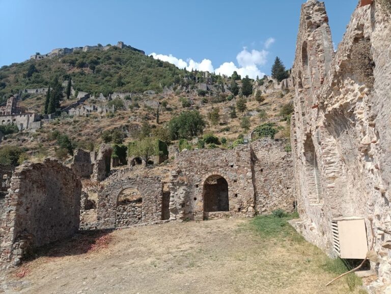
Kalamata Castle occupies an elongated hilltop terrace oriented north to south, with its inner defenses forming a central enclosure. The fortifications incorporate a variety of stone structures that reflect the castle’s layered history of Byzantine and Crusader construction, as well as later modifications from Venetian periods.
Dominating the northern corner of the inner enclosure is the donjon, the main tower of the castle. This rectangular building measures roughly 40 by 60 feet (12 by 18 meters) and features a western annex, about 34 by 16 feet (10.4 by 4.9 meters), which houses a cistern for water storage. The stone blocks forming the cistern appear to have been repurposed from earlier fortifications built during the time of ancient Pharae. Within the donjon survive the remnants of the katholikon church from the Byzantine monastery that occupied the site before Crusader reconstruction, demonstrating the continuity of sacred use amid military adaptation.
Along the eastern side of the inner walls stands a small square tower, while the southeastern bastion guards the castle’s only entrance. Although much of the inner circuit walls have been reduced to their foundational levels, these surviving elements offer glimpses into the castle’s defensive system. The external enclosure walls extend along the eastern slope of the hill, starting from the outer donjon wall and running northeast before turning sharply southeast. This outer circuit includes a small square tower and a gate flanked by a redan, a V-shaped defensive projection. Architectural details such as stone blocks from the Byzantine period are embedded around this southeastern gate area, reflecting the mix of construction phases.
The castle’s walls conform closely to the natural contours of the hill, featuring vertical stone fortifications that once enclosed the summit. Defensive earthworks that may have existed are no longer evident. Over centuries, much of the castle’s stone was removed for local building purposes, leaving the site in a fragmentary and vulnerable state. The upper areas, including the citadel and cistern ruins, have been deemed unsafe for visitors following damage from a 1986 earthquake.
On the southern part of the castle grounds lies a small open-air theater constructed in 1950. This modern addition is used for cultural performances and occupies space within the historic bounds of the castle’s terrain, linking the site’s long heritage with contemporary community use.
Nearby sites