Carrarese Castle in Este: A Medieval Fortress and Museum in Italy


Visitor Information
Google Rating: 4.5
Popularity: Medium
Google Maps: View on Google Maps
Official Website: www.comune.este.pd.it
Country: Italy
Civilization: Medieval European
Remains: Military

History
The Carrarese Castle is situated in the town of Este, Italy, and was originally built by medieval Italian civilization to serve as a fortified military stronghold. Its origins trace back to the mid-11th century when a first fortification was constructed around 1056 by Marquis Alberto Azzo II as a fortified residence, establishing the foundations of the Este family lineage. This early structure stood as a symbol of regional authority and defense.
The initial fortification was destroyed in 1249 during a military campaign led by Ezzelino II da Romano. In the early 1340s, Ubertino da Carrara chose the site to build a new, stronger castle atop the ruins of the former fortress. This new construction marked a significant phase under the Carraresi family, rulers of Padua, who renamed and reinforced the castle, asserting their control over the area. The castle became a focal point in the power struggles characteristic of northern Italy, facing attacks by notable figures such as CanGrande I della Scala in 1317 as well as enduring the broader conflicts between the Carrara dynasty, the Scaligeri family, and the Republic of Venice.
Following the relocation of the Este family’s seat to Ferrara, the castle remained a contested military asset and saw further reinforcements under Venetian rule, especially during the War of the League of Cambrai in 1509. Over time, as its military importance declined, the fortress was converted into a country residence by the Moncenigo family. The significant tower became community property, and by the late 19th century, after negotiations in 1885, the entire castle complex was acquired by the municipality of Este. Subsequent developments transformed parts of the grounds into public gardens and incorporated the surviving palace wing as the National Archaeological Museum of Este.
Remains
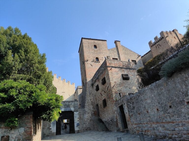
The castle’s layout forms an irregular polygon with eighteen sides of differing lengths, enclosing roughly 4.6 hectares across varied terrain that includes flat areas and gentle hills on the southern edge of the Euganean Hills. Originally, the site was surrounded by the Sirone River, which provided a natural defensive barrier, particularly around the Castelletto del Soccorso—a portion of the fortress dating from 1339 to 1340. This smaller castle section contains one of the two largest remaining towers alongside the main keep, or mastio. The Castelletto’s design catered both to defense and the lodging of troops and benefitted from the natural protection afforded by the river on two sides.
The castle’s walls showcase robust medieval military construction with a principal curtain wall measuring around 1.5 meters thick near the main gate and approximately 1.3 meters elsewhere. These curtain walls, topped by Guelph-style battlements characterized by their distinct squared merlons, rise on average 5.4 meters from the surrounding ground to the walkway used by defenders. The main curtain wall is flanked by two prominent corner towers facing the town. The western one aligns visually with the nearby Duomo church and marks the beginning of the southern enclosure, while the eastern corner tower is known as the San Girolamo tower, a name tied to local religious references.
Originally, the fortress boasted fourteen lateral towers arranged at intervals of 180 to 200 meters along the walls. Today, twelve of these survive, each standing approximately 16.5 meters tall when including their battlements. Their curtain walls maintain a steady thickness of 1.5 meters at their bases, with heights adapted to the changing topography. A 19th-century addition opened an entrance through the southeastern wall, demonstrating later adaptation of the structure.
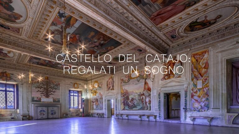
The castle’s main defensive wall is interrupted centrally by the Palazzo Mocenigo, which projects into the fortress enclosure in an L-shaped formation consisting of a central body and two wings. One wing, lost to a fire around 1785, once stood as a prominent feature, while the other now serves as the home of the National Museum dedicated to local archaeology. The site of the destroyed wing currently contains municipal residential buildings, showing the castle’s evolution from military use to civic purposes.
At the heart of the fortress, the mastio or keep, part of the upper rocca (the inner fortress area), is set on a gentler slope of the hill and accessed via stairways leading through two successive courtyards. The first courtyard once was fully enclosed by walls, and the second provides direct access to the keep’s entrance. The keep comprises four floors and retains its historical character following restoration efforts completed in 1968. Since 1969, the mastio has welcomed visitors through its east side, contrasting with its original entrance on the northern face. Together, these features illustrate the castle’s layered construction history and its adaptation to evolving military and administrative needs.
Nearby sites